Spitsbergen is a territory of strategic importance. Open left menu Svalbard Do you need a visa to visit the archipelago
Four hundred years ago life was seething there. The two most "agile" nations of Europe - the British and the Dutch - divided spheres of influence in the archipelago. But to be more precise, there was a whole international community there. Ships from France, Spain, Denmark, Sweden, and German states sailed in the waters of Spitsbergen, not to mention the Norwegians and Pomors.
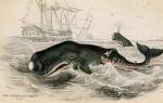
At times, there were four hundred ships in the archipelago’s waters at the same time. The question is, what did they need in this God-forsaken region? Blubber is whale oil, which since the beginning of the 17th century has become one of the most sought-after goods in Europe. Blubber was, in fact, the oil of that time. It was the main lighting material for lamps almost until the end of the 19th century, until it was replaced by kerosene.

Wealthy Europeans abandoned fire-hazardous wax candles and switched to more technologically “advanced” lamps. Surprisingly, this fact definitely influenced their lifestyle.
Thanks to the blubber obtained in the distant Arctic, Europeans began to go to bed later, read more, and most importantly, work more, since lighting in artels using whale oil was cheaper than “wax” lighting. Interestingly, it was extremely unprofitable for the Moscow state to spread blubber in Europe, which was one of the main exporters of wax.

Whale oil smelting plant on Spitsbergen / Cornelis de Man
However, in Rus' at that time there were few officials who could think in terms of global economic strategy. It all started with Willem Barents, who discovered a rocky coast in the Arctic waters in the summer of 1596 and named it Spitsbergen (“sharp mountains”).
Then the Dutch sailors considered that the land was part of Greenland, so they did not lay claim to the “great geographical discovery”. Probably, the name “Spitsbergen” would have “fallen asleep” in the Barents logbook if the Dutch had not discovered a huge pod of bowhead whales in the coastal waters. It was a billion-dollar discovery, and here's why.

Whaling in Europe by that time flourished in the Bay of Biscay. The main whalers in Europe were the Basques, who learned to use a harpoon in the early Middle Ages. When whale oil gained mass demand in Europe in the second half of the 16th century, the Biscay whale fishery turned into mass extermination.
As a result, over several decades, the population of these marine mammals was on the verge of extinction. And now Barents opens a new rich “deposit”. Returning to their homeland, without the tragically deceased Willem Barents, the expedition members found investors, and after some time the first Dutch whaling expedition set off for the Arctic waters.

While the Dutch were gathering an expedition, the British made their discovery of Spitsbergen. In 1607, the archipelago was contemplated by Henry Hudson, who was then working for the British Muscovy Company (Moscow Company), which received a monopoly on trade with Russia from the Russian monarchs. Hudson also noted a large population of whales in coastal waters, which he reported on his return to Britain.
And 3 years later, another employee of the Muscovy Company, Captain John Poole, noted the “incredible abundance of whales” in the waters of Spitsbergen. Sensing a gold mine, a British corporation with a Russian name sent the first whaling expedition in 1611, reinforced by Basque harpooners. However, two ships were catastrophic.

But the English “Muscovites” did not give up, and the following year a new expedition to Spitsbergen was organized. And there a surprise awaited the British sailors: in the waters of the archipelago they met Dutch and French whaling ships.
In 1613, the Muscovy Company decided to end competition once and for all by sending 7 warships to the shores of Spitsbergen, which dispersed several dozen Dutch, Spanish and French ships. This led to international political conflict.
The Dutch, Spanish, and French insisted that the waters of Spitsbergen (all participants called it Greenland) were neutral waters, and the British had no right to a monopoly. In addition, representatives of the Netherlands even declared their advantage, since it was Barents who discovered Spitsbergen.
Representatives of the Muscovy Company, in turn, argued that they received exclusive rights from the “Moscow sovereign.” They say that since the end of the 15th century this land has belonged to the Russians, who even organized settlements there.

Indeed, there is a letter from the German geographer Hieronymus Müntzer to the Portuguese King João II, written at the end of the 15th century, which speaks of the recently discovered island of Grumland (as the Russian Pomors called Spitsbergen), which is part of the possessions of the Grand Duke of Moscow.
Danish admiral Severin Norby, who visited Moscow in 1525 and 1528, reported to King Christian II about Grumland, which belongs to Vasily III. But the king of Denmark and Norway, Christian IV, joined the dispute, who believed that these Arctic territories from time immemorial belonged to the Norwegians and were called Svalbard.

As an argument, an excerpt from an old Norwegian chronicle was cited that in 1194, not far from Iceland, Scandinavian sailors discovered a land that they called “Svalbard” (“cold shores”). In the 20th century, researchers questioned this fact.
Perhaps someone sailed from Iceland at the end of the 12th century and came across some “cold shores”, however, most likely, brave sailors then called Svalbard the area in the east of Greenland or the island of Jan Mayen, which have nothing to do with Spitsbergen.

It is not known whether the British believed in the Norwegian legend, but in 1614 they offered the monarch of the Danish-Norwegian state to buy a monopoly on the island. Christian IV rejected the offer, and in 1615, 3 Scandinavian warriors landed on Spitsbergen in order to collect tribute from the international whalers who had settled there. True, the harpoon workers sent the Norwegians home.
By that time, the Dutch whaling North Greenland Company had agreed with the British “Muscovites” to divide the archipelago into two spheres of influence. Minor “pieces” also went to the French and Danes. The Dutch took up the development of Spitsbergen with maximum intensity. Soon, the whalers' settlement of Smeerenburg grew up on the island of Amsterdam, where up to 200 people worked during the season.

The British settled in more sluggishly, and then the Muscovy company found itself in a difficult financial situation, which allowed the Dutch to actually establish a monopoly on the fishery. After Tsar Alexei Mikhailovich deprived the “Muscovites” of all privileges in Russia, only a few British remained in the archipelago. Well, then the whales ended, and the British and Dutch disappeared along with them.
The archipelago fell into desolation. What about the Pomors? Where were the discoverers of Grumant all this time? The sailors of the Russian North were always nearby. For example, in almost all Arctic expeditions of the Muscovy Company there was always a Russian guide, a pilot, or, as the Pomors themselves called it, “the ship’s leader.” After the British, the Dutch, French, and Danes began to hire Pomors.
In addition, every year Pomor fishermen went to the archipelago to kill walruses and seals, since the Pomors were not interested in whaling. Russian sailors also placed their famous wooden navigation crosses on the archipelago, which everyone relied on.

In those days, it was the Pomeranian cross that was a kind of marker that “Grumant is Russian land, and you, whalers and skilled blubber traders, are just guests.” Interest in the archipelago took a new direction when in 1800 the skipper of the fishing vessel Søren Tsachariassen, returning from a voyage, brought coal of the highest quality from the Isfjord area.
It became clear that Spitsbergen could have huge reserves of high-calorie coal. Then the Swedes, Norwegians, Americans and Russians began to fight for the archipelago. Active mining of “black gold” was put forward as a legal right to own territory.

Whaling ship, Spitsbergen, 1905
Russia, in order to consolidate its presence in the Arctic, has outlined the following mechanism: first develop economic activity, support it with scientific study of the area of interest, and only then take political measures. And when in 1871 the Swedish-Norwegian government wanted a monopoly on the archipelago, Russia responded unequivocally against it.
The Russian Foreign Ministry has always adhered to this fundamental position regarding the ownership of Spitsbergen: “The archipelago cannot be the object of exclusive ownership of any state, and citizens and companies of all states have equal rights here in socio-economic and scientific activities, which must be exclusively peaceful in nature.” "

Russia began to actively defend its rights to Spitsbergen only in 1905. Then the Russian Foreign Ministry decided “to organize some Russian enterprise on the archipelago, not formally owned by the state, which would demonstrate our activities on Spitsbergen and would help the Russian government defend our ancient right to this territory.”
For this purpose, an expedition was organized led by Arctic explorer Vladimir Rusanov. In 1912, he discovered a number of coal deposits, which later helped protect Russian interests in the archipelago. As a result, at international meetings the priority rights to Spitsbergen of three countries - Russia, Norway and Sweden - have always been recognized.

The First World War and the October Revolution of 1917 excluded Russia from the struggle for possession of the islands. Norway took advantage of the "busyness" of its main competitor to achieve sovereignty over Spitsbergen.
On February 9, 1920, in Paris, Great Britain, Denmark, Italy, the Netherlands, Norway, the USA, France, Sweden and Japan signed the Treaty of Spitsbergen, or the Svalbard Treaty, which transferred control of the archipelago to Norway.

Despite the fact that at the time of the signing of the Treaty of Paris Russia was in a state of civil war, Article 10 specifically stipulated the possibility of Russia joining the agreement: “In anticipation that the recognition of the Russian government by the High Contracting Parties will allow Russia to accede to this Treaty, Russian citizens and societies shall enjoy the same rights as citizens of the High Contracting Parties."
In 1935, the USSR took advantage of this opportunity and officially joined the Treaty of Paris. Currently, more than 50 states are parties to the treaty, including landlocked Afghanistan, Slovakia, the Czech Republic and Switzerland.

Significant, by Arctic standards, economic activity on the archipelago, in addition to Norway, according to the special status of the archipelago, is carried out only by Russia, which has a Russian settlement on the island of Western Spitsbergen - the village of Barentsburg, as well as the mothballed villages of Pyramid and Grumant.
The population of the archipelago is approximately 2,600 people, most of whom are Norwegians and 500 people are Russians. The island has a completely visa-free regime, that is, representatives of all nations that signed the Spitsbergen Treaty of 1920 have the right to live and work.

Currently, Spitsbergen is one of the centers of polar and subpolar tourism. In the 2000s, with money from the Norwegian government, the World Seed Vault, the so-called “Doomsday Vault,” was built on the island. This storage facility contains a seed bank of both cultivated and wild plants, designed to survive even in a nuclear war.
Site materials used
The total area occupied by the islands is 61,022 km²
Natural conditions
Mountainous terrain. The highest point of the islands is Mount Newtontoppen (1712 m) in Western Spitsbergen. Glaciers occupy 35.1 thousand km² - more than half the area of the archipelago. The shores are indented by fjords. Permafrost - layer thickness up to 200 m. Natural thawing of soils in summer ranges from 0.5 to 2.5 m.
The archipelago is located in a seismically active zone, earthquakes of magnitude 4-5 on the Richter scale have been recorded, and the possibility of earthquakes up to magnitude 6-7 is possible.
Geological structure
As a rule, the Caledonides participate in the structure of the archipelago. But they are more similar to the Caledonides of Greenland than of Scandinavia. However, both of them are the product of the Early Paleozoic Iapetus Ocean, which opened around the beginning of the Cambrian (550 million years ago). This ancient ocean was located in near-equatorial latitudes in the submeridional direction from 30° S. w. (ancient coordinates) to the north, between the ancient continents of Baltic and Canada-Greenland. Spitsbergen also includes older rocks (Baikal folding), apparently, this is part of the Barents Sea plate, which is Proterozoic-Early Cambrian in age. Much of Svalbard's basement formed somewhere on the active margin of the ancient Iapetus Ocean, about 500 million years ago, in the Early Ordovician, and represents island-arc igneous formations that were severely crushed during the continental collision of the Silurian. By the beginning of the Silurian, the Iapetus Ocean began to shrink, carrying Baltica towards Canada-Greenland, (450-440 million years ago) the British Isles, Newfoundland and Spitsbergen, which experienced strong uplift and volcanic eruptions by the mid-to-late Silurian. Then came the final collision of the Baltic (Scandinavia), British Isles, Greenland, Newfoundland and North America (Laurentia). The remains of ancient island arcs, limestones, and clastic ocean rocks of the Iapetus Ocean were crushed and raised up to 9-11 thousand meters. Where these parts of the world collided, a mountain range rose higher than today's Himalayas. 400 million years ago, Scandinavia was already connected to Greenland and Spitsbergen was located somewhere between them. The British Isles, Newfoundland and North America were also joined together. In the late Paleozoic, intrusion of granitoids occurred in places. The current deposits of copper, chromium, nickel, titanium, iron, zinc, uranium and other metals, which are now located on the Kola Peninsula, Scandinavia, Greenland, Spitsbergen, the British Isles and the east coast of North America, were formed precisely in that era .
Legal status of Spitsbergen
In 1920, as part of the peace conference of Paris, the Spitsbergen Treaty was concluded, which secured Norway's sovereignty over the archipelago, but at the same time all states party to the Treaty had the right to carry out commercial and scientific research activities on the basis of full equality and the demilitarized status of the archipelago (Article 3). According to Article 2 of the Treaty, Norway received the right to protect and restore flora and fauna, although concern for the environmental situation was not typical for that time. In Article 8, Norway pledged to create a Mining Charter regulating economic activities on Spitsbergen, while the charter was not supposed to give privileges, monopolies or benefits to any country, including Norway. In 1925, the Mining Charter for Spitsbergen was adopted together with the National Spitsbergen Law.
Story
Presumably, it was first discovered by the Vikings or Pomors in the 12th century (it was known to the Pomors under the name Grumant; now this is the name of one of the abandoned Russian villages on the islands). Since 1194, a certain Svalbard has been mentioned in Norwegian chronicles. However, it is not certain that today's Svalbard was meant. It could have been Greenland or Jan Mayen.
Whaling
During the Second World War, Svalbard could not act as a full-fledged military base, so its population was evacuated, and the presence of German troops on the archipelago was limited to weather stations dropped from aircraft and submarines, correcting the work of German aviation in the Arctic. To eliminate them, in 1942, a small Norwegian detachment on two ships Isbjørn and Selis was sent to the Longyearbyen area from Scotland. . Despite the fact that both ships were destroyed, the Norwegians managed to gain a foothold on the shore. In 1943, to destroy this detachment, the Germans sent a detachment of ships to Svalbard from the battleship Tirpitz, the cruiser Scharnhorst and nine destroyers, which destroyed most of Longyearbyen and Barentsburg with artillery fire (one of the coal mines that were set on fire was only extinguished in 1960). The German landing on the shore was less successful - the Norwegians in the Barentsburg area resisted coastal artillery fire and retreated into the mountains to the village of Grumant.
In the post-war years, coal mining on the archipelago was resumed by Norwegian companies and Arktikugol, which also acted as the main representative of the Soviet Union in the Arctic. The gradual depletion of proven reserves in the mines of the archipelago has led to a reduction in production everywhere except the Norwegian Sveagruva. As a result, the Norwegian government began to orient Spitsbergen towards the development of tourism and an expeditionary scientific base. Arktikugol could not cope with the task of diversifying economic activity and in the post-Soviet period is subsidized from the state budget. Costs for maintaining the activities of former Soviet concessions in Spitsbergen in 2006 alone amounted to 395.6 million rubles.
Current state

Funicular for transporting coal
Although the Svalbard archipelago is controlled by the Kingdom of Norway and has been officially part of it since 1925, there are differences related to taxation (tax-free zone), environmental protection, protection of local rights and military activities (demilitarized zone). There are two official languages on the islands - Norwegian and Russian; Russian citizens (like citizens of most other countries) do not need a visa to visit the archipelago.
Coal production in the mines is carried out by the Norwegian company Store Norske Spitsbergen Kulkompani and also under a concession by the Russian state trust "Arktikugol" (formerly a Soviet trust). Here (the Barentsburg mine) is the world's northernmost operating railway, which is almost entirely underground. Previously, there were several railways, and they ran along the surface. All mined coal is used to heat Barentsburg itself, that is, the Russian enterprise is a planned loss-making and (partly) image project.
Currently, Svalbard is one of the centers of polar and subpolar tourism; both large cruise ships from northern Europe and specialized ice-class tourist ships for excursions in the Arctic regularly stop at the port of Longyearbyen. The city has several hotels (including SAS Radisson), bars and good restaurants with Arctic cuisine (for example, the Kroa restaurant “At the End of the Earth”). There is a very interesting polar museum and the UNIS University, and significant scientific work is being done to study climate, geology and glaciology. In summer and winter, walking, water (kayak and boat) and snowmobile excursions and expeditions depart from the city daily.
In the 2000s, with money from the Norwegian government, the World Seed Vault, the so-called “Doomsday Vault,” was built on the island. This storage facility contains a seed bank of both domestic and wild plants, designed to survive even in a nuclear war. In addition, the Berget Plateau is home to antennas for the SvalSAT satellite station, the EISCAT incoherent scatter radar, and the KHO Northern Lights Observatory. Svalbard is connected to the mainland by an underwater fiber optic cable; within Barentsburg, Colesbukhta and Longyearbyen there are cellular communications from both Russian (Megafon) and Norwegian operators.
Nature

National parks of Spitsbergen
The climate is harsh, the vegetation is not rich, the plants are short and cold-resistant. At the beginning of summer, the tundra is very swampy due to melting snow, and the rivers have high water levels. Basically, the southern part of Spitsbergen (zero zone) is free of snow in summer, although glaciers are found close to all populated areas. Red algae is often found on glaciers, giving the snow and ice a pinkish tint. Despite the 24-hour polar day, the temperature difference between day and night in summer is noticeable and can reach 5-10 degrees Celsius. The first snowfalls occur in September, although snow is not uncommon at the end of August. Due to its relatively mild climate, Svalbard is also popular with tourists during the polar night, when stable snow and ice cover allows snowmobile traffic.
The population of the archipelago is about 2,600 people (as of January 1, 2009). Of these, 69.9% are Norwegians, 18.3% are Russians and Ukrainians, 0.4% are Poles. The island has a completely visa-free regime, that is, representatives of all nations that signed the Spitsbergen Treaty of 1920 have the right to live and work. In practical terms, despite the lack of immigration and customs controls, the harsh climate and high cost of living in Longyearbyen effectively limit labor migration to workers in the service and tourism industries. After the collapse of the Soviet Union, a number of former Arktikugol employees moved permanently to Longyearbyen, while the population of Russian mining towns continued to decline in proportion to the decline in coal production.
The largest settlement is Longyearbyen, about 2,000 people, the majority are Norwegians. It is also the administrative center of the archipelago. Other settlements:
- Russian mining villages: Barentsburg (470 people), Grumant and Pyramid (mothballed)
- Norwegian international research center Ny-Ålesund (about 30 people, in summer more than 100)
- Norwegian mining village of Sveagruva (90 people, with workers from Longyearbyen more than 300)
- Polish research station Hornsund (10 people).
There is also a preserved port village of Kolesbukhta, which was previously connected to Grumant by railway along the coast. Currently, the road has fallen into disrepair, and the tunnel near the village of Grumant is filled in as a result of soil movements.
| Year | Total | Norse | Russians | Poles |
|---|---|---|---|---|
| 1990 | 3544 | 1125 | 2407 | 12 |
| 1995 | 2906 | 1218 | 1679 | 9 |
| 2000 | 2376 | 1475 | 893 | 8 |
| 2005 | 2400 | 1645 | 747 | 8 |
| 2009 | 2565 | 1792 | 470 | 10 |
Religion
Longyearbyen has the only functioning Lutheran church with its own clergyman. There is an Orthodox chapel in Barentsburg. In the village of Hornsund there is a Polish research station consisting of 10 people. In agreement with the Russian Orthodox Church and the Catholic Church in Norway, the Lutheran pastor ministers to the believers of these churches.
Economy
Since the beginning of the 20th century, coal mining has become the basis of the economy on Spitsbergen. At the same time, local coal seams, as a rule, have access directly from the mountain slope and many places where coal occurs are visible to the naked eye. This geological formation resulted in numerous small mines and coal mines along the coastline, which opened and closed as the seams were exhausted and explored. The size of settlements on Svalbard generally corresponded to the thickness of nearby coal mines.
The depletion of the main easily accessible coal deposits by the mid-70s raised the question of the economic feasibility of the existence of Longyearbyen, which by that time had already been subsidized by the Norwegian government. The Norwegian state-owned company Kings Bay AS, which owned the settlement of Ny-Ålesund, found itself in a similar position. For this reason, the Norwegian government began to actively diversify Svalbard's economy and provided tax benefits to residents of the archipelago. Additionally, in 1993, the mining town of Longyearbyen was sold to the national government, which concentrated on developing a university center and tourism.
Currently, the only major profitable mine in the archipelago is Sveagruva, which is Svalbard's main source of income (NOK 2.008 million in 2007). Coal is also mined at the N7 mine in Longyearbyen, supplying coal to the local power station. The second most important source of income is tourism (317 million crowns), the third source is the provision of scientific activities (142 million crowns). In particular, Kings Bay provides logistical support for about 200 scientists working in the village of Ny-Ålesund during the summer season, and is also responsible for supplying other research stations. The tourism industry is concentrated around Longyearbyen, where tourists fly in from mainland Norway (two flights a day), as well as cruise ships. All types of businesses within Norwegian settlements are showing steady growth. In particular, the surge in hydrocarbon prices in the late 2000s ensured record production in Sveagruva (over 4 million tons per year), and the number of cruise ship passengers increased from 20 thousand in 2005 to 30 thousand in 2008.
Thus, despite significant initial investments by the Norwegian government in airport, seaport and scientific infrastructure, Svalbard is today completely self-sufficient, with an average annual income of residents 23% higher than the Norwegian average.
Russian economic presence
The depletion of the coal-bearing layer at the Pyramid mine in the 1990s put an end to the profitability of Arktikugol, which quickly turned into a subsidized resource. At the same time, the planned government expenditures for the maintenance of the trust amount to 870, 820 and 806 million rubles for 2008, 2009 and 2010, and the activity is reduced to maintaining the life of Barentsburg, which has been mining coal only for its own consumption since 2006. Despite this, Arktikugol management regularly announces the imminent resumption of mining at Pyramid or Grumant - a position partially supported by Norwegian miners. From a political point of view, an open coal mining license for a Russian enterprise facilitates the functioning of Sveagruva, which is often criticized by the Norwegian Green Party, which has already achieved a ban on the extraction of petroleum products in the Svalbard region.
The village of Barentsburg itself is not of long-term tourist interest - despite frequent summer ship voyages from Longyearbyen, most tourists visit the Russian settlement for no more than a couple of hours. The development of an independent tour operator infrastructure in Barentsburg and a scientific and logistics base in Pyramid is hampered by both the lack of ground communication with the airport and the state monopoly on the use of buildings and structures in the villages of the Federal State Unitary Enterprise "GT "Arktikugol". In addition, Barentsburg does not have a repair and logistics base for basing the most demanded (small) ice-class cruise fleet, and suitable vessels of the former Soviet scientific fleet are leased (“Akademik Multanovsky”, “Professor Molchanov”) from foreign companies or sold (“Polar Pioneer" - former “Akademik Shuleikin”, “Akademik Shokalsky” ", "Spirit of Enderby" - former "Professor Khromov") to foreign tour operators.
In the long term, the ice-free port of Barentsburg can be used as a base for servicing the Northern Sea Route, increasing the likelihood of timely provision of icebreaker support and reducing the risks associated with ice damage to ships. The development of Barentsburg in this direction is hampered by the lack of a road to the village. Longyearbyen and the outdated format of Russian economic activity in the region.
Tourism
The archipelago of Spitsbergen (Svalbard) is a Norwegian territory and is governed by a Norwegian governor (Norwegian: Sysselmannen), who sets fairly strict rules for tourism. In particular, tourist helicopter excursions are prohibited on Svalbard. In addition, wild animals (including polar bears) must not be disturbed, and all incidents of lethal force are investigated by the police. Also under protection are traces of human activity before 1946.
To ensure the safety of independent travel through the archipelago, tourists are required to obtain permission to leave the zero zone (which includes Longyearbyen, Barentsburg, Grumant and Pyramid), as well as have insurance and maintain communications using satellite phones or radio stations. The standard walking route in the zero zone is the transition from the village. Longyearbyen through the Adventdalen valley to Kolesbukhta, then to Grumant and return to the village through the Bjoerndalen valley. There are also hiking routes around the glaciers of Isfjord and Pyramid, transfers are made by zodiacs with passing tourist ships on the Barentsburg - Longyearbyen - Pyramid line.
Most polar tourists arrive in Svalbard during the polar day, from March to August. In spring, snowmobile trails and ski trails are most popular, followed by hiking expeditions in July-August. During the polar day, temperatures on Svalbard average around five degrees Celsius, although snowfall is also common. In May-June, the tundra is very swampy and the main tourist routes pass along glaciers and fjords (by kayak).
The development of Arctic cruises has given a good boost to Longyearbyen's hotel industry, which registered 93,000 guests in 2008 at fairly high hotel room rates (from $120). Despite the fact that there are no economy class hotels in the city, tourists can also stay in a hostel or at a campsite directly opposite the airport. There is also a hotel in Barentsburg, but it is of low popularity due to the underdevelopment of the tourism industry in the village.
Weapons and hunting
Svalbard (including Longyearbyen) is on the seasonal migration path of polar bears to the pack ice. Despite the fact that the likelihood of encountering a bear on a polar day at the 78th parallel is small, in the archipelago it is customary to carry large-caliber weapons (rifled or smooth-bore) when leaving Longyearbyen. It is also recommended to have a signal pistol with you and to protect overnight sites with signal mines. There are several sporting goods stores in the city that rent guns and ammunition to tourists. In 2009, the Governor of Svalbard introduced a new rule for renting weapons, for which it is necessary to provide a certificate from the police of the country of residence.
The archipelago is home to a large number of animals (including Svalbard reindeer), but hunting requires obtaining a license from the governor in advance.
Russian projects and prospects
Despite the complete openness of the archipelago to everyone who wants to live and work, there is virtually no private Russian business on Spitsbergen. At the same time, Russian state property is used extremely inefficiently and requires costs both to maintain and to maintain jurisdiction (Norwegian law sets a maximum period for abandonment of objects). To justify permanent subsidies, the management of Arktikugol brought up various projects for discussion - including the resumption of coal mining in Grumant and Pyramid, the development of Barentsburg as a fishing base, etc. At the same time, serious elaboration of the projects was not carried out and there were no public estimates of the cost of building the necessary infrastructure (to for example, the Barentsburg-Longyearbyen land road or the restoration of the Grumant-Kolesbukhta railway) is unknown.
In addition, exotic projects were periodically voiced in Russian periodicals, such as: the construction of ophthalmological and balneological centers in Barentsburg (a powerful source of mineral water was discovered near the village), mining of semi-precious stones, fish processing in a factory staffed by migrant workers, regular mining and primary processing of algae for the needs of poultry farming as a food additive in poultry feed, and so on.
see also
Notes
- Kovacs K.M., Lydersen Ch. Birds and mammals of Svalbard. Polarhandbok No. 13. - Oslo, 2006, 203 p.
- V.V. Slavinsky Thermal regime of the lithosphere of passive continental margins on the examples of North-Western Spitsbergen and South-Eastern Australia // Materials of the XLII Tectonic Meeting. - Moscow: Geological Institute (GIN) RAS, 2009. - T. 2. - P. 191-195.
- A.I. Konyukhov How many Atlantic oceans were there? . Archived from the original on June 3, 2012. Retrieved February 11, 2012.
- http://www.norway.mid.ru/sp_ru.html About Spitsbergen. History // Official Web site of the Embassy of the Russian Federation in Oslo, Norway
- ORTELIUS, ABRAHAM "Septentrionalium regionum Descrip.", 1570s.
- Svalbard's history - the cruise book from Svalbard. Norsk PolarInstitute. Archived
- S. Patyanin // Operation “Citronella”. tsushima.org.ru. Archived from the original on February 17, 2012. Retrieved November 10, 2010.
- PROBLEMS OF THE NORTH AND THE ARCTIC OF THE RUSSIAN FEDERATION, SCIENTIFIC INFORMATION BULLETIN ISSUE SIXTH October, 2007. Federation Council of the Federal Assembly of the Russian Federation. Archived from the original on February 17, 2012. Retrieved November 2, 2010.
- “Language on Spitsbergen” - travel.ru
- “Visas to Spitsbergen” - travel.ru
- Order of the Ministry of Economic Development of the Russian Federation (Ministry of Economic Development of Russia) dated April 4, 2011 N 142 Moscow “On approval of the Rules for the provision of subsidies from the federal budget to the federal state unitary enterprise State Trust Arktikugol” Rossiyskaya Gazeta
- “The Great Book of Disasters” Nikolai Nepomnyashchy ISBN 5-373-00693-9, 9785373006934
- http://www.ssb.no/befsvalbard_en/tab-2009-10-22-01-en.html
- Norwegian statistics data
- Meet the Svalbard Archipelago. What the numbers tell us Statistics Norway
- Will we build factories in the Arctic? Murmansk Vestnik
- Spitsbergen. History of domestic development of the archipelago
Literature

- Natalia Kozlova Island of Arrested Ships // Russian newspaper: newspaper. - 2005. - No. 3904.
- Nadezhda Sorokina Moscow will not weaken its position on Spitsbergen // Russian newspaper: newspaper. - 2006. - No. 4024.
- E. M. Singer Country of mountains and glaciers // Nature: magazine. - 1997. - No. 8.
- L. M. Savatyugin, M. V. Dorozhkina Spitsbergen Archipelago: Russian names and titles. - St. Petersburg: Science, 2009. - 272 p.
- N. A. Gnilorybov Coal mines in Spitsbergen. - Moscow: Nedra, 1988. - 191 p.
- E. M. Singer Spitsbergen is an ice archipelago. - Moscow: Penta, 2006. - 302 p.
- F. N. Chernyshev Russian expedition to Spitsbergen. - Peace of God. - 1901. - 261 p.
- N. E. Koroleva, N. A. Konstantinova, O. A. Belkina, D. A. Davydov, A. Yu. Likhachev, A. N. Savchenko, I. N. Urbanavichene Flora and vegetation of the coast of Grønfjord (Spitsbergen archipelago). - Apatity: Publishing house. K&M, 2008. - 132 p.
- Kokin O.V. Relief and sediments of the marginal zones of glaciers in Western Spitsbergen.
- Starkov V.F. Essays on the history of Arctic exploration. Volume 1: Spitsbergen / Ed. Dr. History Sciences A.K. Stanyukovich. .. - Ed. 2nd. - M.: Scientific world, 2009. - 96 p. - 300 copies. - ISBN 978-5-91522-101-6(region)
Links
| Portal "Spitsbergen" | |
| Spitsbergen on Wikimedia Commons |
- in the "Modern Encyclopedia"
- Sysselmannen.no - website of the Governor of Svalbard
- Svalbard Tourism - website of the official tourist board
- TopoSvalbard - interactive map from Norwegian Polar Institute (Norwegian) (English)
- The story of one city: Longyearbyen (Spitsbergen) on the “Echo of Moscow”
| Polar archipelago Svalbard | |
|---|---|
| Basics | Geography · Story · Population · Climate · Vegetable world · Education · Religion · Policy · Spitsbergen Treaty · Kings Bay Case · UNIS |
| Transport | Svalbard Airport · Ny-Ålesund Airport · Svea Airport |
| Companies | Bjornøen · Kings Bay · Store Norske · Arktikugol · Aeroflot (1973 - 1994) · Vnukovo Airlines (1994 - 1996) · Lufttransport · Scandinavian Airlines |
| Communications and media | Svalbardposten · Internet domain.sj · Svalbard Subsea Cable System |
| Settlements and NIS | Barentsburg · Longyearbyen · Nybyen · Ny-Ålesund · Sveagruva · Belsheoya · Virgohamna · Hamburg bay · Grumant · Itre Norskoya · Colesbay · Kobbefjord · Leagerneset · Pyramid · Sverdrupbyen · Smerenburg · · Yellow River · Himadri · Hornsund |
| Islands of the archipelago | |
| Geographical objects | Adventdalen · Adventfjord · Belsund · Billefjord · Valenbergfjord · Vanmuiden bay · Vanmienfjord · Verlegenhukenfjord · Westfonna · Vijdefjord · Woodfjord · Land of Olav V · Isfjord · Kronebrin · Cape Kremer · Miserifjellet · Nordenskiöldbreen · Kapp Linne · Kapp Payer · Kongsfjord · Crossfjord · Lifdefjord · Mandalenfjord · |
Spitsbergen is an impressively sized island archipelago lying in the vastness of the western part of the Arctic Ocean. In fact, the lands belong to the royal house of Norway, but Russia also has its own settlements on the archipelago. The administrative center of Spitsbergen is the city of Longyearbyen.
Geography and nature of the island of Spitsbergen
The archipelago includes three large islands: Edge, North-Eastern Land, Western Spitsbergen; seven less significant ones: White, Barents, Royal, Bear, Swedish, Wilhelm, Prince Charles Land. How to get to the .
The highest point of the archipelago is Mount Newtontoppen with a height of 1712 m. The eternal ice sheet covers 35 thousand km2, which is more than half of the total territory of the islands. The coastal zones are cut by wonderful fjords, which become objects of interest for tourists in Europe.
Svalbard is dominated by tundra flora. These are polar willow, dwarf birch, various types of fungi, lichens, as well as mosses and vascular plants. The fauna is represented by polar bears, of which there are countless numbers. They are accompanied by Arctic foxes and Svalbard reindeer. The latter are considered the smallest of the reindeer. Previously, scientists tried to artificially populate the islands with Greenland musk oxen and hares, but this venture failed. Among the marine inhabitants we will highlight: ringed seals, bearded seals, walruses, whales, beluga whales, and harp seals. Except for polar bears, all inhabitants are found in large numbers near populated areas.
More than half of all territories are included in the environmental protection zone: three reserves and three reserves.
Finally, about the climate. The Arctic weather is moderated on the western side of the archipelago by the warm Spitsbergen Current, which in turn originates from the Gulf Stream. On the coast, the average winter temperature reaches -14C; summer +4.4C. Moreover, a temperature difference of 20C is possible, both in the negative and in the positive direction.
DURING the search for the northeastern passage from the Atlantic Ocean to China and India on June 19, 1596, the Dutch navigator W. Barents unexpectedly saw on the horizon a thin strip of unknown land stretching to the north. After some time, the teeth of a fragmented mountain range and snow-white ribbons of glacial streams appeared. Barents designated the unknown country with pointed peaks in the ship's log as Spitsbergen (Sharp Mountains).
No one disputes the right of Barents to be considered the official discoverer of Spitsbergen. However, the Spitsbergen expedition of the Institute of Archeology of the Russian Academy of Sciences under the leadership of V.F. Starkov clearly proved that already in the middle of the 16th century. On Spitsbergen there were settlements of Russian Pomors, who were then called the Grumant archipelago.
Spitsbergen Islands, Grumant 
The history of the development of the archipelago is full of countless exciting events and facts. It owes this to long-standing attempts to populate it, hunting and whaling, mineral exploration, coal mining, and famous polar expeditions. The comparative proximity to the mainland and the relatively easy accessibility of Spitsbergen attracted hundreds of brave, inquisitive and enterprising people to it.
An indisputable confirmation of the role of Russia and its sons in the history of the exploration and development of Spitsbergen is the fact that today on its geographical map we see many Russian names. However, the word “Russian” itself is very popular when denoting various geographical objects - it is present in the name of a bay, river, valley, islands, etc.
Until the First World War, Spitsbergen remained a no-man's land. But on February 9, 1920, at the Paris Peace Conference, representatives of the USA, Great Britain, France, Italy, the Netherlands, Denmark, Sweden and Norway signed the Spitsbergen Treaty, according to which sovereignty over the archipelago was transferred to Norway. Citizens of the countries that signed the treaty were given the right of free access to the waters of Spitsbergen, and were allowed to engage in fishing and hunting, shipping, industrial and trade operations on equal terms with Norway. The Norwegians were obliged not to create naval bases and fortifications on the archipelago.
In 1925, Norway included the archipelago as part of its possessions. Spitsbergen itself and the surrounding islands of Bely, King Charles Land, Nadezhda, which lies much to the south of Bear, as well as a number of smaller islands, the Norwegians called the Svalbard archipelago (translated from the ancient Norwegian language - Cold Land, or Country with Cold Shores). Svalbard is a special administrative unit, 95% of its territory belongs to the state, and the rest to the so-called treaty land owners. The USSR joined the Paris Treaty on Spitsbergen in 1935, and in accordance with it and the Mining Charter, we conduct economic and scientific activities on the archipelago. In Russia, as well as in many other countries of the world, the new name of Spitsbergen did not take root.
Raudfjord Spitsbergen Islands, Grumant 
The islands of the archipelago are limited in the north by 81 degrees north latitude, in the south by 74 degrees north latitude, in the west by 10 degrees north latitude, and in the east by 35 degrees east latitude. The area of the archipelago is about 63 thousand km2. And although it has thousands of islands, islets and just rocks, there are only five large islands - Western Spitsbergen, North-East Land, Edge, Barents and Prince Charles Land. The archipelago is washed by the waters of the Arctic Ocean, Greenland, Norwegian and Barents Seas.
One of the northernmost archipelagos on Earth, Spitsbergen is a classic country of polar research. Nowadays, this archipelago is a convenient scientific testing ground for the development of new methods and approaches of many sciences, primarily geology, geophysics, glaciology, paleogeography, ecology, biology, and archeology. Spitsbergen is the only visa-free natural site in our time where diverse international scientific cooperation has long been established and is developing fruitfully.
walrus, Magdalena fjord Spitsbergen Islands, Grumant 
GEOGRAPHY OF THE ARCHIPELAGO
Spitsbergen (German: Spitzbergen), also Svalbard (Norwegian: Svalbard), Spitsbergen (Dutch: Spitsbergen), Grumant - a vast polar archipelago located in the Arctic Ocean, between 76°26" and 80°50" north latitude and 10° and 32°E longitude. The northernmost part of the kingdom of Norway. The administrative center is the city of Longyearbyen. The archipelago and coastal waters are a demilitarized zone.
Significant, by Arctic standards, economic activity on the archipelago, in addition to Norway, according to the special status of the archipelago, is carried out only by Russia, which has a Russian settlement on the island of Western Spitsbergen - the village of Barentsburg, as well as the mothballed villages of Pyramid and Grumant.
The archipelago consists of three large islands - Western Spitsbergen, Northeast Land and Edge Island; seven smaller islands - Barents Island, Bely Island, Prince Charles Land, Kongsøya (Royal Island), Bear, Svenskøya (Swedish Island), Wilhelm Island; as well as groups of islands, small islets and skerries (total area 621 km²).
Largest islands:
Island Area (km²)
Western Spitsbergen 37,673
Northeast Land 14,443
Edge 5074
Barents 1288
White 682
Prince Charles Land 615
Kongsøya 191
Bear 178
Svenskøya 137
Wilhelma 120
Others (total area) 621
Total 61,022
Three Crowns mountain range Spitsbergen Islands, Grumant 
Natural conditions
Mountainous terrain.
The highest point of the islands is Mount Newton (1712 m) in Western Spitsbergen. Glaciers occupy 35.1 thousand km² - more than half the area of the archipelago. The shores are indented by fjords. Permafrost - layer thickness up to 200 m. Natural thawing of soils in summer ranges from 0.5 to 2.5 m.
Tundra vegetation includes dwarf birch (lat. Bétula nána), polar willow (lat. Salix polaris), mosses, mushrooms, lichens and more than 170 species of vascular plants.
The only mammals on the islands are the polar bear, the Svalbard reindeer (the smallest of the reindeer species), and the Arctic fox. Attempts to move other land mammals to the archipelago, in particular polar hares and musk oxen from Greenland, were unsuccessful. The archipelago has an abundance of marine animals - seals, harp seals, bearded seals, walruses, beluga whales, and whales. All of the listed animals (except for polar bears) are quite often found in close proximity to populated areas.
About 90 species of birds are recorded on Svalbard, of which 36 constantly nest in the archipelago. The only species that lives on Svalbard all year round is the arctic partridge (lat. Lagopus mutus hyperboreus). The remaining birds fly to southern countries for the winter, and return to the archipelago only in the spring for nesting and breeding.
About half of the territory is occupied by environmental protection zones: 3 reserves and 3 sanctuaries.
Large deposits of high-calorie coal are estimated at 10 billion tons. A unique feature of Svalbard is also the significant number of rocks with fossilized remains of plants and animals. In 2007, a Norwegian group of paleontologists managed to discover the remains of the largest pliosaur, Pliosaurus funkei, on the archipelago. The high diversity of geological rocks of the archipelago is explained by its long migration through the Earth's mantle, during which Spitsbergen visited different climatic zones.
The current climate is Arctic, significantly softened in the west by the warm Spitsbergen Current (part of the Gulf Stream). The average air temperature on the coast is from +4.4 °C (July) to −10…−14 °C (January). Due to the influence of the Gulf Stream, winter temperatures on Spitsbergen are on average 20 degrees higher than in other places of comparable latitude. The maximum recorded temperature is +24.5 °C (July 1978), the minimum is −46.3 °C (March 1986).
The archipelago is located in a seismically active zone, earthquakes measuring 4-5 on the Richter scale have been recorded, and the possibility of earthquakes up to 6-7 is expected.
Glacier Monaco Spitsbergen Islands, Grumant 
Nature
National parks of Spitsbergen
The climate is harsh, the vegetation is not rich, the plants are short and cold-resistant. At the beginning of summer, the tundra is very swampy due to melting snow, and the rivers have high water levels. Basically, the southern part of Spitsbergen (zero zone) is free of snow in summer, although glaciers are found close to all populated areas. Red algae is often found on glaciers, giving the snow and ice a pinkish tint. Despite the 24-hour polar day, the temperature difference between day and night in summer is noticeable and can reach 5-10 degrees Celsius. The first snowfalls occur in September, although snow is not uncommon at the end of August. Due to its relatively mild climate, Svalbard is also popular with tourists during the polar night, when stable snow and ice coverage makes snowmobile travel possible.
Geological structure
As a rule, the Caledonides participate in the structure of the archipelago. But they are more similar to the Caledonides of Greenland than of Scandinavia. However, both of them are the product of the Early Paleozoic Iapetus Ocean, which opened around the beginning of the Cambrian about 550 million years ago. This ancient ocean was located in near-equatorial latitudes in the submeridional direction from 30° S. w. (ancient coordinates) to the north, between the ancient continents of Baltic and Canada-Greenland. Spitsbergen also includes more ancient rocks (Baikal folding). Apparently, this is part of the Barents Sea plate, which is Proterozoic-Early Cambrian in age. Much of Svalbard's basement formed somewhere on the active margin of the ancient Iapetus Ocean about 500 million years ago in the Early Ordovician and represents island-arc igneous formations that were severely crushed during continental collisions in the Silurian. By the beginning of the Silurian, the Iapetus Ocean began to shrink, carrying Baltica towards Canada-Greenland, (450-440 million years ago) the British Isles, Newfoundland and Spitsbergen, which experienced strong uplift and volcanic eruptions by the mid-to-late Silurian. Then came the final collision of the Baltic (Scandinavia), the British Isles, Greenland, Newfoundland and North America (Laurentia). The remains of ancient island arcs, limestones, and clastic oceanic rocks of the Iapetus Ocean were crushed and raised up to 9-11 thousand meters. At the site of the collision of these parts of the world, a mountain range rose higher than today's Himalayas. 400 million years ago, Scandinavia was already connected to Greenland and Spitsbergen was located somewhere between them. The British Isles, Newfoundland and North America were also joined together. In the Late Paleozoic, granitoids were intruded in places. The current deposits of copper, chromium, nickel, titanium, iron, zinc, uranium and other metals, which are now located on the Kola Peninsula, Scandinavia, Greenland, Spitsbergen, the British Isles and the east coast of North America, were formed during that era.
seagulls on the Lillehoek glacier 
Story
Presumably, it was first discovered by the Vikings or Pomors in the 12th century. It was known to the Pomors under the name Grumant; now this is the name of one of the mothballed Russian villages on the islands. Since 1194, a certain Svalbard has been mentioned in Norwegian chronicles. However, it is not certain that today's Svalbard was meant. It could be Greenland or Jan Mayen.
In 1596, the islands were "indisputably" discovered and documented by the Dutchman Willem Barents, who gave the main island the name "Spitsbergen", which means "sharp mountains". Barents discovered a large number of walruses and whales on the island and in its adjacent waters, which gave rise to numerous fishing expeditions. Around the same time, the archipelago appeared on Russian maps under the name “Holy Russian Islands”. A few years later, England and Denmark declared their claims to these lands.
blue whale Spitsbergen Islands, Grumant 
Whaling
In the 17th and 18th centuries it was used by various countries as a whaling base until whales were almost completely exterminated from the region. The center of Dutch whaling since 1614 was the village of Smeerenburg. Norway, along with Iceland and Japan, continues this fishery today, despite the moratorium of the International Commission for the Regulation of Whaling and the ban on the export of whale meat.
In 1765-1766, Mikhail Lomonosov organized two marine scientific expeditions to Spitsbergen under the leadership of V. Ya. Chichagov, but the harsh climate did not allow the organization of permanent settlements on the archipelago and until the beginning of the 20th century Spitsbergen did not have an official Russian presence. Nevertheless, Pomors maintained a seasonal hunting presence on the archipelago, and the most desperate of them regularly remained for the winter.
After the collapse of the whaling and fur trades at the end of the 18th century, over the next hundred years Svalbard was virtually abandoned and was considered terra nullius - no man's territory, that is, despite the nominal claims to it by various countries, it was actually not governed by anyone. A new wave of interest began only at the end of the 19th century, when year-round access to ports and a relatively mild climate made Spitsbergen the main base for polar expeditions and Arctic tourism.
The archipelago has been visited by many famous explorers, including Fridtjof Nansen, Roald Amundsen and Ernst Shackleton. The northern part of the island of Western Spitsbergen is named Andre's Land, in honor of Solomon Andre, who attempted to reach the North Pole in a hot air balloon in 1897. In 1912, Western Spitsbergen was also described and mapped in detail as part of the last expedition of the famous Russian Arctic explorer and pioneer of the Northern Sea Route V.A. Rusanova. The first Arctic tourists, wealthy Europeans, including the representative of the royal family of Monaco, Prince Albert, also visited Spitsbergen.
Since the beginning of the 20th century, the economic situation on the islands began to gradually change. Coal mining by American, English, Norwegian, Russian and Swedish enterprises led to the organization of permanent settlements. Norway's sovereignty over the archipelago was recognized in 1920, when the United States, Great Britain, France, Italy, Japan, Norway, the Netherlands and Sweden signed the Spitsbergen Treaty in Paris. The Norwegians were in a hurry to secure the disputed lands in the absence of their main rival, the Russian Empire, which determined the unprecedented terms of the treaty. According to the agreement, all countries participating in the treaty retained the right to extract and develop mineral resources in the archipelago. On May 7, 1935, the USSR also joined it, which by that time already had several workers’ settlements on Spitsbergen.
Since the mid-1920s, Spitsbergen has become world famous as a base for polar aviation - for example, Roald Amundsen's seaplane flights with the money of the American millionaire Lincoln Ellsworth. On May 21, 1925, Amundsen sets off from Spitsbergen to Alaska via the North Pole, but does not make it and returns to Spitsbergen. On May 11, 1926, the Amundsen-Ellsworth-Nobile expedition departed from Spitsbergen on an airship designed by Umberto Nobile. Having flown over the pole (piloted by the airship Nobile), the expedition landed in Alaska. Under Mussolini, Umberto Nobile, already a general and an honorary member of the ruling fascist party, decided on May 23, 1928 to repeat the flight to the North Pole. Starting from Spitsbergen, he reached the Pole, but on the way back the airship crashed. Amundsen, who flew out in search of Nobile, died, and the surviving members of the airship crew were rescued on July 12 by the Soviet icebreaker Krasin.
During World War II, Spitsbergen could not act as a full-fledged military base, so its population was evacuated, and the presence of German troops on the archipelago was limited to weather stations dropped from airplanes and submarines, correcting the work of German aviation in the Arctic. To eliminate them, in 1942, a small Norwegian detachment on two ships Isbjørn and Selis was sent to the Longyearbyen area from Scotland. Despite the fact that both ships were destroyed, the Norwegians managed to gain a foothold on the shore. In 1943, to destroy this detachment, the Germans sent a detachment of ships from the battleships Tirpitz, Scharnhorst and nine destroyers to Spitsbergen, which destroyed most of Longyearbyen and Barentsburg with artillery fire (one of the coal mines that were set on fire was only extinguished in 1960). The German landing on the shore was less successful. The Norwegians in the Barentsburg area resisted with coastal artillery fire and retreated into the mountains to the village of Grumant.
In the post-war years, coal mining on the archipelago was resumed by Norwegian companies and Arktikugol, which also acted as the main representative of the Soviet Union in the Arctic. The gradual depletion of proven reserves in the mines of the archipelago has led to a reduction in production everywhere except the Norwegian Sveagruva. As a result, the Norwegian government began to orient Spitsbergen towards the development of tourism and an expeditionary scientific base. Arktikugol could not cope with the task of diversifying economic activity and in the post-Soviet period is subsidized from the state budget. Costs for maintaining the activities of former Soviet concessions in Spitsbergen in 2006 alone amounted to 395.6 million rubles.
Woodfjord Spitsbergen Islands, Grumant 
Current state
Although the Svalbard archipelago is controlled by the Kingdom of Norway and has been officially part of it since 1925, there are differences related to taxation (tax-free zone), environmental protection, protection of local rights and military activities (demilitarized zone).
There are two official languages on the islands - Norwegian and Russian; Russian citizens do not need a visa to visit the archipelago.
Coal production in the mines is carried out by the Norwegian company Store Norske, as well as under a concession by the Russian state trust Arktikugol (formerly a Soviet trust). Here (the Barentsburg mine) is the world's northernmost operating railway, which is almost entirely underground. Previously, there were several railways and they ran along the surface. All mined coal is used to heat Barentsburg itself, that is, the Russian enterprise is a planned loss-making and partly an image project.
Currently, Spitsbergen is one of the centers of polar and subpolar tourism; both large cruise ships from northern Europe and specialized ice-class tourist ships for excursions in the Arctic regularly stop at the port of Longyearbyen. The city has several hotels (including SAS Radisson), bars and good restaurants with Arctic cuisine (for example, the Kroa restaurant “At the End of the Earth”). There is a very interesting polar museum and the Svalbard International University, and significant scientific work is being carried out on the study of climate, geology and glaciology. In summer and winter, walking, water (kayak and boat), snowmobile excursions and expeditions depart from the city daily.
In the 2000s, with money from the Norwegian government, the World Seed Vault, the so-called “Doomsday Vault,” was built on the island. This storage facility contains a seed bank of both cultivated and wild plants, designed to survive even in a nuclear war. In addition, on the Berget plateau there are antennas for the SvalSAT satellite station, the EISCAT incoherent scatter radar, and the KHO aurora observatory. Svalbard is connected to the mainland by an underwater fiber optic cable; within Barentsburg, Colesbukhta and Longyearbyen there are cellular communications from both Russian (MegaFon) and Norwegian operators.
Longyearbyen city Spitsbergen Islands, Grumant 
Population
The population of the archipelago is about 2,600 people (as of January 1, 2009). Of these, 69.9% are Norwegians, 18.3% are Russians, 0.4% are Poles. The island has a completely visa-free regime, that is, representatives of all nations that signed the Spitsbergen Treaty of 1920 have the right to live and work. In practical terms, despite the lack of immigration and customs controls, Longyearbyen's harsh climate and high cost of living effectively limit labor migration among service and tourism workers. After the collapse of the Soviet Union, a number of former Arktikugol employees moved permanently to Longyearbyen, while the population of Russian mining towns continued to decline in proportion to the decline in coal production.
The largest settlement is Longyearbyen, about 2000 people, the majority are Norwegians. It is also the administrative center of the archipelago.
Other settlements:
Russian mining villages: Barentsburg (470 people), Pyramid (3-4 people in winter, about 15 in summer, mostly mothballed) and Grumant (mothballed)
Norwegian international research center Ny-Ålesund (about 30 people, in summer more than 100)
Norwegian mining village of Sveagruva (90 people, with workers from Longyearbyen more than 300)
Polish research station Hornsund (10 people).
There is also a preserved port village of Kolesbukhta, which was previously connected to Grumant by railway along the coast. Currently, the road has fallen into disrepair, and the tunnel near the village of Grumant is filled in as a result of soil movements. Spitsbergen Islands, Grumant
Religion
Longyearbyen has the only functioning Lutheran church with its own clergyman. There is an Orthodox chapel in Barentsburg. In the village of Hornsund there is a Polish research station consisting of 10 people. In agreement with the Russian Orthodox Church and the Catholic Church in Norway, the Lutheran pastor ministers to the believers of these churches.
Economy
Since the beginning of the 20th century, coal mining has become the basis of the economy on Spitsbergen. At the same time, local coal seams, as a rule, have access directly from the mountain slope and many places where coal occurs are visible to the naked eye. This geological formation resulted in numerous small mines and coal mines along the coastline, which opened and closed as the seams were exhausted and explored. The size of settlements on Svalbard generally corresponded to the thickness of nearby coal mines.
Norway
The depletion of the main easily accessible coal deposits by the mid-1970s raised the question of the economic feasibility of the existence of Longyearbyen, which by that time had already been subsidized by the Norwegian government. The Norwegian state-owned company Kings Bay, which owned the settlement of Ny-Ålesund, found itself in a similar position. For this reason, the Norwegian government began actively diversifying the Svalbard economy and providing tax benefits to residents of the archipelago. Additionally, in 1993, the mining town of Longyearbyen was sold to the national government, which concentrated on developing a university center and tourism.
Currently, the only large profitable mine in the archipelago is Sveagruva, which is the main source of income for Svalbard (NOK 2,008 million in 2007). Coal is also mined at Mine No. 7 in Longyearbyen, supplying coal to the local power station. The second most important source of income is tourism (317 million crowns), the third is the provision of scientific activities (142 million crowns). In particular, Kings Bay provides logistical support for about 200 scientists working in the village of Ny-Ålesund during the summer season, and is also responsible for supplying other research stations. The tourism industry is concentrated around Longyearbyen, where tourists fly in from mainland Norway (two flights a day), as well as cruise ships. All types of businesses within Norwegian settlements are showing steady growth. In particular, the surge in hydrocarbon prices in the late 2000s ensured record production in Sveagruva (over 4 million tons per year), and the number of cruise ship passengers increased from 20 thousand in 2005 to 30 thousand in 2008.
Thus, despite significant initial investment by the Norwegian government in airport, seaport and scientific infrastructure, Svalbard is now completely self-sufficient, with an average annual income of residents 23% higher than the Norwegian average.

Russia
The depletion of the coal-bearing layer at the Pyramid mine in the 1990s put an end to the profitability of Arktikugol, which quickly turned into a subsidized resource. At the same time, the planned government expenditures for the maintenance of the trust amount to 870, 820 and 806 million rubles in 2008, 2009 and 2010, and the activity is reduced to maintaining the life of Barentsburg, which has been mining coal only for its own consumption since 2006. Despite this, Arktikugol management regularly announces the imminent resumption of mining at Pyramid or Grumant - a position partially supported by Norwegian miners. From a political point of view, an open coal mining license for a Russian enterprise facilitates the functioning of Sveagruva, which is often criticized by the Norwegian Green Party, which has already achieved a ban on the extraction of petroleum products in the Svalbard region.
The village of Barentsburg itself is not of long-term tourist interest - despite frequent summer ship voyages from Longyearbyen, most tourists visit the Russian settlement for no more than a couple of hours. The development of an independent tour operator infrastructure in Barentsburg and a scientific and logistics base in Pyramid is hampered by both the lack of land connections to the airport and the state monopoly on the use of buildings and structures in the villages of FSUE GT Arktikugol. In addition, Barentsburg does not have a repair and logistics base for basing the most popular (small) ice-class cruise fleet, and suitable vessels of the former Soviet scientific fleet are leased (“Akademik Multanovsky”, “Professor Molchanov”) from foreign companies, or sold to foreign companies tour operators: Polar Pioneer - former "Akademik Shuleikin", "Akademik Shokalsky", Spirit of Enderby - former "Professor Khromov".
In the long term, the ice-free port of Barentsburg can be used as a base for servicing the Northern Sea Route, increasing the likelihood of timely provision of icebreaker support and reducing the risks associated with ice damage to ships. The development of Barentsburg in this direction is hampered by both the lack of a road to Longyearbyen and the outdated format of Russian economic activity in the region.
polar bear, Kongsfjord Spitsbergen Islands, Grumant 
Tourism
The archipelago of Spitsbergen (Svalbard) is a territory of Norway and is governed by a Norwegian governor (Norwegian Sysselmannen), who determines fairly strict rules for tourism. In particular, tourist helicopter excursions are prohibited on Svalbard. In addition, wild animals (including polar bears) must not be disturbed, and all incidents of lethal force are investigated by the police. Also under protection are traces of human activity before 1946.
To ensure the safety of independent travel in the archipelago, tourists are required to obtain permission to leave the zero zone (which includes Longyearbyen, Barentsburg, Grumant and Pyramid), as well as have insurance and maintain communications using satellite phones or radio stations. The standard zero zone hiking route is from Longyearbyen through the Adventdalen valley to Kolesbuchta, then to Grumant and returning through the Bjoerndalen valley. There are also hiking routes around the glaciers of Isfjord and Pyramid, the transfer is carried out by “zodiacs” with passing tourist ships on the Barentsburg - Longyearbyen - Pyramid line.
Most polar tourists arrive in Svalbard during the polar day, from March to August. Snowmobile trails and ski trails are the most popular in the spring, followed by hiking expeditions in July and August. During the polar day, temperatures on Svalbard average around five degrees Celsius, although snowfall is also not uncommon. In May-June, the tundra is very swampy and the main tourist routes pass along glaciers and fjords (by kayak).
The development of Arctic cruises has given a good boost to Longyearbyen's hotel industry, which registered 93 thousand guests in 2008 at a fairly high cost of hotel rooms (from 120 US dollars). Despite the fact that there are no economy class hotels in the city, tourists can stay in a hostel or at a campsite directly opposite the airport. There is also a hotel in Barentsburg, but it is of low popularity due to the underdevelopment of the tourism industry in the village.
Weapons and hunting
Svalbard (including Longyearbyen) is on the seasonal migration path of polar bears to the pack ice. Despite the fact that the likelihood of encountering a bear on a polar day at the 78th parallel is small, in the archipelago it is customary to carry large-caliber weapons (rifled or smooth-bore) when leaving Longyearbyen. It is also recommended to have a signal pistol with you and to protect overnight sites with signal mines. There are several sporting goods stores in the city that rent weapons and ammunition to tourists. In 2009, the Governor of Svalbard introduced a new rule for renting weapons, for which it is necessary to provide a certificate from the police of the country of permanent residence.
The archipelago is home to a large number of animals (including Svalbard reindeer), but hunting requires obtaining a license from the governor in advance. Spitsbergen Islands, Grumant 
Russian projects and prospects
Despite the complete openness of the archipelago to everyone who wants to live and work, there is virtually no private Russian business on Spitsbergen. At the same time, Russian state property is used extremely inefficiently and requires costs both to maintain and to maintain jurisdiction (Norwegian law sets a maximum period for abandonment of objects). To justify permanent subsidies, the management of Arktikugol brought up various projects for discussion: including the resumption of coal mining in Grumant and Pyramid, the development of Barentsburg as a fishing base, etc. At the same time, serious elaboration of the projects was not carried out and public estimates of the cost of building the necessary infrastructure (to for example, the Barentsburg-Longyearbyen land road, or the restoration of the Grumant-Kolesbukhta railway) are unknown.
In addition, exotic projects were periodically voiced in the Russian media: the construction of ophthalmological and balneological centers in Barentsburg (a powerful source of mineral water was discovered near the village), the extraction of semi-precious stones, the processing of fish in a factory staffed by migrant workers, the regular extraction and primary processing of algae for needs of poultry farming as a food additive in poultry feed and so on. Spitsbergen Islands, Grumant 
COUNTRY OF MOUNTAINS AND GLACIERS
VISA-FREE NATURAL SITE
Due to the structural features and the wide variety of geological formations on Spitsbergen, rocks of different ages coexist, from Precambrian to Quaternary, and, what is especially valuable for researchers, they are not hidden from view.
In the first half of the Tertiary period, the archipelago was covered by the sea. Sedimentary rocks several hundred meters thick accumulated in the basins. They contain remains of fossilized marine animals and plants. At the end of the Tertiary period, the land rose and the islands were covered with broad-leaved forests, where, along with oaks, maples, ash trees, lindens and beeches, such heat-loving trees as magnolia, swampy cypress, plane tree and gigantic sequoia grew. The remains of this vegetation in the rocks indicate that the climate on Spitsbergen was then much warmer and wetter than it is now.
About 3 million years ago, air and water temperatures in the Northern Hemisphere dropped noticeably and the forest landscape was replaced by tundra. But glaciation spread especially widely several hundred thousand years ago. Giant ice sheets formed and reached the temperate latitudes of Europe and North America. At that time, most of Spitsbergen was covered with glaciers... Millennia passed - they either retreated or advanced again. Their area varied greatly, shrinking to modern and even smaller sizes.
Norwegian geologists approximately estimate the reserves of high-calorie coal in the bowels of the archipelago at 10 billion tons. The main coal region is located in the central part of Western Spitsbergen, where all four currently operating mines are concentrated. Since the 60s, geologists in a number of countries have been actively searching for oil on the islands of the archipelago and especially on its shelf - according to some data, they are very promising in terms of oil and gas potential. The results of several exploratory drilling wells are also convincing of this.
Earthquakes of magnitude 4-5 have been recorded in Spitsbergen. Seismologists admit the possibility of maximum earthquakes of up to 6 - 7 points. The archipelago is experiencing vertical uplift of the earth's crust at a rate of about 5 mm per year. Thanks to this, sea terraces up to 100 meters or more high were formed. Spitsbergen was once the scene of strong volcanic activity. In the north there are two extinct volcanoes, in the area of which there are hot springs and fumaroles. The archipelago is located in a zone of stable permafrost, interrupted only under the bottom of bays and in river valleys. The permafrost thickness reaches approximately 200 m. In summer, only a small top layer thaws - from 0.5 to 2.5 m.
Compared to Franz Josef Land, Novaya Zemlya and Severnaya Zemlya to the east, Svalbard is located closer to the Icelandic center of persistent low pressure. In the area of the archipelago there is a boundary between the warm waters of the North Atlantic Current and the cold waters of the Arctic Basin. Most of the atmospheric precipitation falls in the western, southern and eastern parts of Spitsbergen, while mainly the coastal strip several tens of kilometers wide is moistened. While the amount of precipitation towards the center of the archipelago decreases sharply, the average air temperature in the same direction increases.
The harsh climate of the high latitudes of the Arctic is softened by a branch of the warm Norwegian Current, one of the branches of the Gulf Stream, running along the western coast of Spitsbergen. Thanks to its influence, the sea off the western shores of Spitsbergen is often ice-free even in winter, while the eastern straits are usually clogged with ice in summer. In the western part of the archipelago, in the depths of winter, thaws and rain occur. The highest air temperature (24.5o) was recorded in July 1978, and the lowest (-46.3o) in March 1986. It is worth mentioning that Spitsbergen is characterized by frequent magnetic storms, sharp changes in atmospheric pressure and air temperature , strong snow storms.
Like any region of the Arctic, Spitsbergen is characterized by long polar nights and days. From October 28 to February 14, i.e. more than 100 days, the sun does not appear above the horizon. But from April 20 to August 20 - about 130 days - it does not leave the sky.
The largest island of the archipelago is Western Spitsbergen, its area is 39 thousand km2. It is a typical mountainous country with numerous pointed mountains and ridges. Although the mountains are low (the highest point of the island and the archipelago, Mount Newton reaches 1717 m), they are strongly dissected. In the east, the mountains turn into a plateau up to 800 m high. The western and northwestern shores of the island are cut by bays that protrude far into the land. The largest of them - Isfjord and Veidefjord - wedge respectively from the west and north into the very center of the island, cutting it into two parts. The peculiarity of the western bays is that they often do not freeze until January-February and are free of ice in May-June. To a large extent, this contributes to the establishment of long-term sea communication between the mainland and the main villages of the archipelago.
Lillehoek fjord Spitsbergen Islands, Grumant 
GLACIALIZATION OF THE ARCHIPELAGO
An integral and characteristic feature of Spitsbergen is extensive glaciation, the area of which exceeds 35 thousand km2. About 60% of the surface of Spitsbergen is encased in many meters of ice armor, which gives its nature a special beauty and attractiveness. The total ice reserve in the glaciers of the archipelago is about 7.5 thousand km3. The reserve of “solid” water, concentrated in glaciers, is 30 times greater than the annual flow of the Volga.
Spitsbergen, Franz Josef Land, Novaya Zemlya and Severnaya Zemlya are part of the same glaciological province. But Spitsbergen is the first among them to receive heavy precipitation brought by cyclones from the North Atlantic to the Eurasian Arctic. Thus, the glaciation of the three Russian archipelagos and Spitsbergen are interconnected. In addition, elucidating the conditions for the existence and development of active glaciers on Spitsbergen is important for understanding the patterns and features of the evolution of glaciation throughout the Eurasian Arctic. Fluctuations in polar ice caps are well known to serve as a sensitive natural indicator of global climate change.
The glaciation of Spitsbergen, which is extremely diverse in morphology, regime and dynamics, makes it a unique glaciological object in the entire Arctic. Here, as if in a miraculous fantastic open-air museum, almost all the different types of glaciers existing on the globe are concentrated. This diversity is due to differences in the relief and climate of the archipelago.
The bulk of glaciers cover mountain valleys and plateaus, and the height of the surface of glaciers rarely exceeds 1000 m. In winter, many glaciers have internal and subglacial runoff and periglacial ice. The presence of water lubricant stimulates the sliding of ice masses, which contributes to their mechanical instability. Ultimately, this causes a sharp regular movement (pulsation) of the glacier - surge. There are over 50 pulsating surge glaciers on Svalbard. The most unstable of them have a two-layer structure of “cold” and “warm” water-containing ice.
Reticulated (or Svalbard) glaciation is of particular interest to glaciologists. From the air, it may seem like a giant chessboard, where the white fields are glacial streams that have filled more than half the system of valleys in the region and connect with each other in the upper reaches, and the black fields are individual sharp peaks and mountain ridges sticking out of the ice.
According to the nature of glaciation, the entire territory of Spitsbergen is divided into three large areas. The first, cover glaciation, includes the island of North-Eastern Earth. Most (80%) of this second largest island of the archipelago is occupied by three significant glacial domes (Austfonna, Vestfonna and Sørfonna) with a total area of about 11 thousand km2. The volume of ice concentrated in them is 44% of the total volume of ice on the archipelago. Mountain-cover glaciation occurs on the islands of Western Spitsbergen, Prince Charles Land, Barents and Edge. The bulk of the glaciers of the archipelago (more than 60%) are located on the island of Western Spitsbergen. The area of mountain glaciation occupies the middle central part of this island, stretching from south to north.
The practical study of the glaciers of the archipelago is caused by the need to know the features of their regime and structure when designing villages, mines, roads, bridges, transmission lines... This is also required to take into account the valuable reserves of “solid” water, since most of the populated areas of Spitsbergen are used for drinking and economic activities melted snow and glacial waters. Finally, the glaciers can also be considered a recreational area of the archipelago, since they are a favorite place for islanders to ride high-speed snowmobiles - snow scooters and skis.
The Second World War interrupted the study of Spitsbergen. A new milestone in research began after the work of the International Geophysical Year (1957/58). At this time, Swedish and Polish scientific stations were operating in the North-Eastern Land and in the south of Western Spitsbergen. However, it must be admitted that until the mid-60s, the glaciation of Spitsbergen remained clearly insufficiently studied. There was not even a general summary of its glaciers. Comprehensive and systematic glaciological studies carried out by expeditions of the Institute of Geography of the USSR Academy of Sciences on Franz Josef Land, Novaya Zemlya and the Polar Urals suggested the need for a detailed study of the glaciation of Spitsbergen. The first Glaciological expedition to the Norwegian archipelago was organized by the Institute of Geography in 1965. Since then, 27 expeditions have been carried out. For several field seasons, glaciologists from the Institute of Geography conducted joint research on the glaciers of Spitsbergen with colleagues from the University of Silesia (Poland) and the Norwegian Polar Institute.
EXPEDITIONS OF THE INSTITUTE OF GEOGRAPHY
Over many years of field work, expedition members made hundreds of many kilometers of routes throughout the archipelago on foot, on skis, by boat and helicopter. A huge series of studies was carried out on the internal structure, hydrodynamic regime and evolution of glaciers in connection with climate change. For the first time in the history of Spitsbergen, radar sounding and deep thermal drilling of wells with ice core sampling for various analyzes were successfully used on glaciers.
Based on the delay time and the nature of the reflected radio signals, it is possible to determine the profiles of ice thickness and subglacial relief, as well as study the internal structure of the glacier. Radar studies of about 150 glaciers of various types and shapes were carried out from a helicopter. The greatest ice thickness was found on the Austfonna dome (North-Eastern Earth) and the Holtedal glacial plateau (northwest of Western Spitsbergen) - about 600 m. 60 wells were drilled in different ice formation zones, including 25 core wells.
The deepest wells that reached the bedrock were those drilled on the Amundsen glacial plateau (southern part of the island of Western Spitsbergen) and in the center of the Austfonna dome - 586 and 566 m, respectively. As a result of drilling, repeated changes in nutrition during the formation of the glacial strata were established, due to changes in climatic conditions over the last millennium2. It was possible to identify climate warming in the 16th century and cooling in the 17th - first half of the 19th centuries. (“Little Ice Age”) and warming since the end of the 19th century. More than a century after the end of the “Little Ice Age,” the Svalbard glaciation has experienced relatively warm climatic conditions. Over the past few decades, Svalbard has experienced a slow cooling and, as a consequence, a slowdown in the retreat of glaciers...
One of the main features of the expeditions of the Institute of Geography was the study of glacial processes throughout the archipelago in combination with stationary observations on several reference glaciers located in different areas. In 1995, together with the National Institute of Polar Research (Japan) on the Austfonna ice dome at 79° latitude. Electromechanical cable core drilling was carried out and a continuous core was taken to a depth of 210 m for subsequent comprehensive isotope geochemical analysis. At the same time, a structural and stratigraphic description of the core, measurements of pH values and electrical conductivity of the upper horizons, well thermometry, excavation work, meteorological observations and other studies were carried out.
Currently, the Spitsbergen Glaciological Expedition is participating in the project “Mechanisms of interaction of polar glaciers with the atmosphere and ocean and the evolution of glaciation” (headed by V.M. Kotlyakov). The goal of the project is to study the patterns and mechanisms of global and regional changes in climate and the natural environment of the Arctic, the regime and evolution of glaciers and ice sheets, the reconstruction of glaciation and climate fluctuations over the past 20 thousand years and their forecast to identify the role of glaciation in changes in the level of the World Ocean. This work will be carried out based on ice core analysis and numerical modeling in Svalbard, Franz Josef Land and Severnaya Zemlya. The summarized results should be included in the collective final monograph “Modern and Ancient Glaciation of the Arctic.”
LIFE IN SPITSBERGEN
Despite the fact that more than half of Svalbard's area is occupied by glaciers, the land areas located next to them support quite diverse life. Botanists have counted more than 160 species of flowering plants here. During the short, cool summer, the surface of the rocky and swampy tundra is transformed in some areas beyond recognition. It is rare, but you can see Lilliputian trees. These are dwarf birches and willows, the height of which does not exceed ... 30, and the thickness is 2 - 3 cm. And their round leaves are no larger in size than lingonberries.
The fauna of Svalbard is not very rich. The most popular animal here, of course, is the polar bear - a powerful predator, a kind of living emblem of the archipelago. Indeed, its image can be found everywhere: on souvenirs, badges, calendars, pennants, clothes, bags, postcards, stamps... It is interesting that the former owner of the Arctic was first described as an independent species on Spitsbergen more than 200 years ago by the English scientific expedition of Captain K .Phipps. The long-term polar station of the Polish Academy of Sciences, located in the south of the island of Western Spitsbergen, is annually “visited” by 200 - 300 polar bears, which is associated with the migration route they have long developed. In the archipelago, many cases of animals entering villages and base areas of expeditions and tourists have been recorded. Insidious attacks on people usually ended tragically. This danger should always be kept in mind in the Arctic.
The reindeer population in Svalbard is impressive. Until recently, hunting him, like bears, was prohibited. However, the governor now issues licenses for large-scale deer shooting. Until recently, musk oxen were found on the islands, which were brought from Greenland in 1929. They acclimatized and multiplied on the archipelago. However, due to thick ice crusts on the surface, which arose as a result of alternating thaws and frosts in the 70s and 80s, it became extremely difficult for musk oxen to obtain pasture, and mass mortality of animals began. Near the villages you can see arctic foxes, and on the sea ice - pinnipeds, mainly seals. Here and there there are rookeries of huge walruses. Cetaceans, including herds of beluga whales, enter the bays. The coastal waters are home to cod, haddock, halibut and other commercial fish. In addition to fishing, shrimp fishing has also been developed. Char, also known as Spitsbergen salmon, is found in lakes and rivers.
The bird world of Svalbard is rich. Most of them are connected with the sea. There are several dozen species of birds living on steep cliffs. Different types of gulls nest in the noisy bird colonies: guillemots, loons, waders. The most common birds are guillemots, puffins or sea parrots. The eider is the most numerous species of duck and lives outside the markets, like loons and geese. Only the ptarmigan and snowy owl remain to spend the winter on the archipelago. Nesting areas of aggressive long-tailed Arctic terns are found in open areas and near villages. There are also very small birds from the order of passerines - buntings, they are the first to bring the desired news from the distant continent to the archipelago about the imminent approach of spring... In order to preserve the easily vulnerable polar nature on Spitsbergen, national parks, reserves and nature reserves were created in the early 70s reserves. They occupy half the area of the archipelago.
Svalbard is the country with the longest history of organized tourism in the Arctic. It first appeared at the end of the 19th century, when the Norwegian shipping company Vesterålen opened regular traffic on comfortable ships from Norway to the archipelago. The captain of the first of them was the famous sailor and associate of Nansen and Amundsen - Otto Sverdrup. Enterprising people immediately built a hotel with forty rooms and a post office on the shore of the Adventfjord, where it meets Isfjord. For lovers of polar exoticism, they began to issue a special postage stamp with an image of a polar bear. But due to the high cost of rooms, tourists stayed less and less often. In the end, the world's northernmost hotel had to close.
On September 2, 1975, King Olav V of Norway inaugurated the airport at Cape Hotel (the name remained from the old hotel). Nowadays, powerful airliners fly here from the mainland almost every day. With the advent of maritime navigation, tens of thousands of organized and hundreds of “wild” tourists from all over the world flock to Spitsbergen.
There is no permanent population on the archipelago; people come here to work for one or two years under a contract. Many of them come back again. There is a belief that a polar “bacillus” settles in a person who once finds himself in the Arctic, infecting him with an incurable “disease” - love for nature and the exotic nature of the North.
In the administrative center there are the offices of the coal company "Sture Noshke" and the Svalbard Travel Bureau, the Norwegian Polar Institute, a seaport, radio and television and weather stations, hotels, a post office, a bank, a museum, a hospital, shops, restaurants, cafes, a school with a swimming pool... Svalbard International University opened in 1994! Dozens of cars of different brands (including taxis) scurry along the asphalt roads, schoolchildren race on motorcycles, mopeds and bicycles, and young mothers carry their polar babies in strollers. During the weekend, many Norwegians, being big nature lovers, go hiking - in the summer on boats and motor boats, and in the winter on snowmobiles and skis. Very popular are small cozy dacha houses scattered throughout the nearby valleys and bay coasts...
At the northwestern tip of Spitsbergen, on the 79th parallel, there is one of the most beautiful bays of the archipelago - Kongsfjord. On the flat coast of the bay, near pyramidal mountains and glaciers, there is a small village. Ny-Ålesund. From here in 1925, 1926 and 1928. The famous expeditions of R. Amundsen, R. Baird and W. Nobile started to the North Pole on airplanes and airships. One of the northernmost settlements on Earth, formerly better known as Kingsbay, owes its origins to the construction here in 1917 of the world's northernmost coal mine. Due to frequent collapses and explosions of methane gas, which led to accidents, the mine was closed in 1963. This is today reminded by a monument to the memory of the dead miners, a mining museum, an old waste heap and a small locomotive that once carried trolleys with coal to the port.
Currently, Ny-Ålesund has become a tourist and research center for Svalbard. There are scientific stations in Norway, France, Germany, England and Japan. Tourist and fishing boats often moor at the pier, and a small airstrip near the village receives local single- and twin-engine planes and helicopters making regular flights from Longyearbyen. On the eastern outskirts there is a 34-meter triangular openwork metal mast, to which the airships "Norway" and "Italy" moored 70 and 68 years ago. Not far from this place, on a low hill, grateful descendants erected monuments to the brave R. Amundsen and the members of the U. Nobile expedition, who died off the northern shores of Spitsbergen after returning from the North Pole. All these buildings, as well as the village of Ny-Ålesund itself, are silent witnesses to the heroic history of the exploration of the Arctic and Spitsbergen.
The third Norwegian village is located in the upper reaches of the Van Meyenfjord, a little south of Logierbyen. In 1917, the Swedes built a mine here and called it Sveagruva - "Swedish Mine". Subsequently, the mine with the coal deposit was acquired by the Norwegians. Currently, they are mining here on a rotational basis, delivering miners from Longyearbyen by plane and helicopter. The mined coal is exported mainly to the “capital”, where after enrichment it is sent further to the mainland.
On Cape Linnea, at the southernmost entrance to the largest bay of the Isfjord archipelago, the Norwegian weather station Isfjord Radio is located. It was built after a powerful lighthouse was installed here. The large station, now saturated with modern technology and automation, is served by only three specialists and a cook!
Very close to here, on the eastern shore of Grönfjord, perched on several mountain terraces is the village of Barentsburg, the largest Russian coal mine in Spitsbergen. In 1932, the Arktikugol trust acquired the Barentsburg land plot along with the mine from the Dutch Spitsbergen company Nespiko. Already in 1936, it surpassed all other Svalbard mines in coal production.
The supply of Svalbard coal to the northern regions of the USSR and its maritime fleet in the Arctic becomes very significant before the Second World War. But the Barentsburg and Grumant mines, which were then operating, as well as the Pyramid mine under construction, had to be closed at the beginning of the war. People were taken to the mainland. The Norwegians were also evacuated. After this, control of Spitsbergen temporarily passed to the Germans. In 1942, a group of Norwegian patriots landed in Barentsburg in order to prevent them from using the archipelago. Until the fall of 1942, the Soviet mine served as the main base for paratroopers. From here, radio operators transmitted weather reports to England. German bombers regularly attacked Barentsburg. In November 1942, ship guns were brought from England. One of them was installed five kilometers from the village on the eastern entrance cape in Grönfjord. On September 8, 1943, this gun took part in an unequal battle with the fascist squadron led by the battleships Tirpitz and Scharnhorst. As a result of the attack, Barentsburg and Grumant were completely destroyed and burned. Longyearbyen and Sveagruva. After the war, they all rose from the ruins and began producing coal again. However, the Grumant mine was closed in 1961.
Currently, Russia, represented by the Arktikugol State Trust, owns 26 land plots on Spitsbergen with a total area of more than 250 km2. Modern Barentsburg and Pyramid are highly mechanized, autonomous mines. In addition to mines, they also include villages, seaports, helicopter stations, electromechanical workshops, heating plants, car parks, television stations, subsidiary farms... Sea vessels deliver coal mined here to the Kola Peninsula, Arkhangelsk, as well as to Western Europe . In recent years, many of the post-war wooden buildings at the mines have given way to three- and four-story stone houses with all the amenities, and the streets and roads have received a normal surface. Life has also been noticeably improved by such new buildings as large beautiful Palaces of Culture with cinema halls and libraries, sports complexes with swimming pools and stadiums, local history museums, hotels, cafes...
Good neighborly relations have long been established between residents of Norwegian and Russian villages. Miners regularly exchange various professional and tourist delegations and groups. Every year in winter and summer, international sports competitions and amateur art concerts are held at the mines. Such meetings have become a pleasant tradition. This is always a noticeable event in the harsh life of the islanders, temporarily cut off from their home and loved ones.
At the very beginning of the 80s, a scientific town came into operation on the southern outskirts of Barentsburg. In addition to the hydrometeorological observatory, it included expeditionary bases of the Russian Academy of Sciences and Geologists "Sevmorgeo" from St. Petersburg. All this contributed not only to the improvement of the lives of northerners, but also to the intensification of scientific activity. It remains to be regretted that recently the situation with the financing of scientific research, including in Spitsbergen, has sharply worsened. It is enough to note that the glaciological expedition of the Institute of Geography of the Russian Academy of Sciences in 1996 included, in addition to the author of the article, only one more glaciologist. I really want to believe that this is not forever. After all, Spitsbergen remains a unique natural laboratory for solving many pressing scientific problems.
THE TOP OF EUROPE - MYSTERIES OF THE ARCTIC
This mountainous archipelago, lost in the icy expanses of the Arctic, is often called the “Top of Europe.” Some of its islands are located beyond the eightieth degree of northern latitude. Only northern Greenland and the Canadian island of Ellesmere are located even closer to the North Pole.
In the morning fog, sailors approaching the archipelago from the south seem to see the outlines of the towers of medieval castles emerge from the haze. The mountain peaks of Spitsbergen, reaching 1700 meters in height, darken through the gray veil.
But then the ship comes closer, the fog dissipates, and a panorama of intricately rugged black rocky shores, crowned with white glaciers, opens before your eyes. In some places, ice tongues descend straight to the sea, ending in ledges of transparent blue ice. Narrow winding bays are lined with foamy stripes of waterfalls. And in the depths of the largest bay - Isfjord - the houses of the capital of Spitsbergen - the village of Longyearbyen - glow welcomingly with bright red, green and blue cubes.
More than a thousand islands are part of the archipelago. True, almost all of them are small, only five of them deserve the epithet “large”. These are Western Spitsbergen, Northeast Land, Edge Island, Barents Island and Prince Charles Land. Spitsbergen is larger in area than Switzerland and could accommodate two Belgiums on its islands.
Since ancient times, the archipelago has had several names. The Dutch called it Spitsbergen, the Russians - Grumant, the Norwegians - Svalbard. Modern journalists often call this region the “Isles of Fogs.” Indeed, Spitsbergen is one of the foggiest places on Earth. Even the famous African Skeleton Coast - the Namib Desert and the Bering Sea, notorious for its rain and fog, cannot compare with it in this regard. More than 90 days a year (a quarter of the year!) there are fogs over the islands. And in June-October there are 12 to 20 days of fog every month.
The fogs on Spitsbergen are so dense that you can’t see anything even five steps away. Sounds are muffled, the outlines of objects are distorted, so that it is impossible to recognize even familiar terrain. All buildings and large stones are covered with a fluffy brush of frost.
In the spring, during fog, you can observe an unusual optical phenomenon, which in the language of scientists is called “gloria”. The low polar sun casts long shadows of objects surrounded by a rainbow outline onto the veil of fog and low clouds. The famous polar explorer Amundsen, who made an emergency landing on a plane in the ice north of Spitsbergen, describes Gloria as follows:
“Away from us, in the fog, I saw a complete reflection of our car, surrounded by a halo of all the colors of the rainbow. The spectacle is amazing, beautiful and unique.”
From afar, from aboard a motor ship heading to Spitsbergen, you can see the intricately jagged peaks of the mountains, for which it was given its name (Spitsbergen - “Sharp Mountains” in Dutch). This name was given to the archipelago by the Dutch navigator Willem Barents, who discovered it in 1596. True, in fairness, it must be said that Russian Pomors, two centuries before the Dutchman, sailed their boats to the cold Grumant (as they called the archipelago).
One day, four Russian hunters, having landed here to hunt, did not find their ship crushed by ice the next morning. The Russian Robinsons lived on Spitsbergen for six whole years before they were rescued by another Russian ship that accidentally visited the islands.
After Barents, many famous navigators and explorers visited the archipelago. Hudson and Chichagov, Nordenskiöld and Nansen, Amundsen and Rusanov laid out their routes here. But the main contribution to the study of Spitsbergen, undoubtedly, was made by the brave Pomors, who mastered the harsh islands for five centuries. To this day, on the map of the archipelago you can find the Russian Islands and Russkaya Bay, Admiral Makarov Mountain and Cape Ermak, the Rusanov Valley and Solovetskaya Bay.
The unique nature of Spitsbergen is determined by the fact that one of the branches of the warm North Atlantic Current, a continuation of the Gulf Stream, approaches its western coast. Heated waters through the fjords penetrate deep into the islands and warm them. In February, the frost here does not exceed fifteen degrees, and the average annual temperature on the islands is six degrees above zero. (And this is at eightieth latitude!)
Therefore, in summer the coast of the islands is covered with a green carpet of tundra, full of bright colors. Purple saxifrage, yellow polar poppies, blue forget-me-nots and purple carnations delight the eyes of the residents of Logier and other Svalbard villages: Barentsburg, Pyramiden, Ny-Ålesund, Longyearbyen and Sveagruva during the long polar day. And the snow fields on the slopes at this time in some places turn pink - due to the appearance of microscopic algae on them.
Wide valleys going high into the mountains are filled with glaciers. Their silent, dirty-white rivers slowly (usually at a speed of a meter per day, no more) move towards the sea. Where glaciers flow into fjords, the ice slides into the water and breaks off. This is how icebergs form. In some Valleys, where the glaciers end before reaching the shore, short but turbulent rivers flow from under them, the longest of which is only 48 kilometers. In winter they all freeze to the bottom.
The mountain peaks of the islands, carved by glaciers, take on the most fantastic shapes. Thus, Mount Skansen resembles an ancient fortress, Mount Tempel is an ancient Indian temple, and Mount Pyramid looks like a stack of giant neatly stacked bales of hay. The most famous mountain, Tre Kruner, has three peaks. Their names: Svea, Nora and Dana symbolize the brotherhood of the three Scandinavian countries - Sweden, Norway and Denmark. The truncated pyramidal contours of the three peaks are colored with clear horizontal stripes of yellow limestone and red sandstone.
Ancient Scandinavian legends imagined Spitsbergen as a gloomy land of cold, darkness, snow and ice. The Vikings believed that this was the most inhospitable region in the world. But it's not fair. Compared to other Arctic islands, such as Ellesmere or Severnaya Zemlya and Franz Josef Land, Svalbard looks like a real oasis in the icy polar desert. It is inhabited by three thousand people, mostly northern researchers and, oddly enough, miners. Coal deposits were formed here hundreds of millions of years ago, when Spitsbergen was one with Europe and its climate was incomparably warmer than now. Now Russian miners, in agreement with the Norwegians, are mining coal here.
But life on the islands can be found not only in human settlements. Here you can find reindeer and arctic foxes, nimble rodents - lemmings and white partridges. A polar owl silently circles over the valleys, and in the summer thousands of migratory birds fly here: ducks, geese and swans.
Most of the noise and splashing is on the coast. With the warm current, flocks of cod and herring, halibut and haddock come to the island, and behind them come seals: harp and bearded seal. On pebble beaches under the rocks, fanged walruses make their rookeries, and in the open sea you can often see fountains of whales. There are still a lot of the latter in the waters of Spitsbergen, although whaling fleets have hunted in these places since the times of the Barents and Hudson. Most of them are beluga whales and killer whales, but the famous narwhal unicorn is also found.
The head of this whale ends with a sharp two-meter bone growth, similar to a horn. They say that Ivan the Terrible had a staff made of a beautiful, twisted narwhal horn (apparently brought by Russian Pomors from Grumant). The main seal hunter, the polar bear, also comes to the islands. The largest predator in the polar basin is now protected by law and is not at all afraid of humans. Sometimes meetings with him end sadly for polar explorers, especially on distant islands.
And it happens that desperate radiograms like the following fly to Barentsburg or Longyearbyen from researchers working somewhere on the Prince Charles Islands: “Urgently send a helicopter for evacuation. Surrounded by nine hungry bears. We don’t risk leaving the house.”
The musk ox, brought here from Greenland in the 1920s, has also taken root on the archipelago. The herd of these powerful squat ungulates, covered with thick and long hair reaching to the ground, has grown noticeably in recent years, fortunately, their main enemies, wolves, are not on Spitsbergen. In harsh winters, female musk oxen hide small cubs under their bellies, where, in any snowstorm, it is warm and cozy in a canopy of wool. Now there are more than a hundred musk oxen on Spitsbergen, but at the beginning there were only 17.
The highlight of Spitsbergen is its wonderful bird colonies. On the tiny ledges of steep cliffs that drop down to the sea, tens of thousands of kittiwakes, guillemots, guillemots, fulmars, puffins and cormorants buzz and fuss. And predatory glaucous gulls hover over the rocks, looking for prey.
There is plenty of fish in the sea for both seals and seagulls, especially since off the western coast, even in winter, under the influence of a warm current, the border of floating ice forms a deep bend, like a bay with icy shores, facing north. In the old days it was called Whaler Bay, since it was here that the whaling center was located. In other winters there is no ice at all on the western coast, and Isfjord is covered with ice only for a month and a half.
However, the North is the North, and from October to February the polar night reigns over Spitsbergen. Nevertheless, the archipelago does not become a “land of eternal darkness” at this time. In clear weather it is illuminated by the moon.
As the great polar explorer Fridtjof Nansen wrote, “instead of the sun, what remains is the most delightful radiance of the moon: it circles the sky day and night...”. Moonlight is reflected by myriads of snow and ice crystals and allows you not only to move freely without a flashlight, but also to distinguish distant mountains. It is especially bright during the full moon.
And in December-January, in frosty weather, auroras blaze in the sky. Against the background of the flaming sky, light patterns of the most fantastic kind appear, continuously changing their shape and color. You can stand for hours, forgetting to put on a hat, in the bitter cold, unable to take your eyes off the amazing play of colors in the cold sky. Words are powerless to describe this truly grandiose spectacle. What a pity that there are no tourists on the islands at this time! Just the opportunity to admire the sky's sparkles would make it worth coming to Spitsbergen in winter.
I have had the opportunity to communicate more than once with people who have visited this distant archipelago. And they all could not forget its harsh beauty, the dazzling white mountain peaks and the blue surface of the fjords, the deafening hubbub of bird colonies and the modest charm of tundra flowers, the greenish-transparent walls of coastal glacial cliffs and the colors of the northern lights...
And when the winterers, returning to their native land, sail from the shore, they traditionally throw old boots into the water from board the ship - as a sign that they will someday return to this cold but beautiful land.
Northeast Land
Northeast Land is an uninhabited island in the Spitsbergen archipelago, in the Arctic Ocean. Belongs to the territory of Norway. It occupies an area of 14.5 thousand square kilometers.
The surface of the island is a plateau, up to 637 meters high. Of the entire surface of the island, 11,135 square kilometers are occupied by glaciers. Mosses and lichens grow in ice-free areas. There are a significant number of fjords on the northern coast of Northeastland.
On one of the islands of the Spitsbergen archipelago in the village of Longyearbyen, a grain storage facility was built, which was called the second “Noah’s Ark”.
The storage facility is a huge structure in the form of an underground one hundred and twenty-meter tunnel. All types of grain are stored in it. Every country in the world has its own section. An unusual grain bank was created to keep seeds safe in the event of a global catastrophe (nuclear war, global warming, asteroid impact, etc.).
The island was not chosen by chance for the construction of the “ark”: its distance from the mainland, geological stability, rocks and low ambient temperature (minus 18⁰ C) can serve as a natural refrigerator. Under such conditions, seeds of cereals and legumes will be stored for millennia.
Norway, o. Spitsbergen, Longyearbyen
Mount Pyramid
The mountain is located near the village of the same name in the former USSR, and later Russia, and for quite a long time served as one of the richest coal mines. In 1998, the mine was closed and the village was evicted to the mainland. Today this village resembles an abandoned lunar station, and in the period from 1956 to 1996. it was a fairly advanced mining village, with a developed infrastructure and capital buildings quite suitable for northern conditions, suitable for housing and leisure.
Now the territory of the village of Pyramid belongs to Norway. The Norwegians quickly adapted it into a tourist attraction and today they bring tourists here for quite a lot of money. But despite this, much more restoration work is required in the village. Today only 17 people live here.
The tourist season here lasts throughout daylight hours from March to August, but even in summer the air temperature does not exceed 4-5°C. It is especially interesting and beautiful here in the spring, when there is still snow and you can move around on skis. The movement of tourists is controlled by local authorities with a mandatory entry in the log and regular contact via satellite phone.
The mountain and the village are located in the southeastern part of the island of Spitsbergen, Norway
Arctic Ocean
The Arctic Ocean is one of the smallest oceans on Earth. It is located in the northern hemisphere of the earth between North America and Eurasia. The ocean covers an area of 14.75 million square kilometers. The average ocean depth is 1,225 meters, and the greatest is 5,527 meters in the Grenada Sea. The volume of water in the ocean is 18.07 million square kilometers.
Visually, the ocean can be divided into three natural waters: the Arctic Basin, the North European Basin and the Canadian Basin. Due to its favorable geographical location in the central part of the ocean, the ice cover remains intact throughout the year, while being in a mobile state. Considering that the water in the ocean is very cold, only marine inhabitants that are resistant to cold temperatures can live here - such as whales, penguins, fur seals and many others.
Eastfjord
Indre Vijdefjorden is a Norwegian national park located in the central-northern part of the island of Western Spitsbergen. It covers the southern end of Vijdefjord, of which Austfjorden is the eastern branch.
Its peculiarity is that it literally crashes into the island. It is a narrow, winding sea bay with rocky shores. Rising cliffs covered with dense vegetation and snow-capped mountain peaks are all part of Austfjorden. Its dimensions are 32 kilometers long and 4-6 kilometers wide. Geographically, the Eastfjord begins on the western side of Cape Peter Mann.
Simple tourist routes often pass through it, the goal of which is to climb one of the peaks of the island. Both professionals and beginners who do not have any special climbing skills take part in them.
The fjord is located in the Indre-Vijdefjorden National Park in Spitsbergen
Abandoned mining village Pyramid
Pyramid is an abandoned Soviet mining village located on the island of Spitsbergen in Norway. The village was built in the second half of the twentieth century near the world's northernmost coal mine. Its population reached a thousand people. But in the nineties, coal production fell sharply and the village was mothballed.
Now the Pyramid is a ghost village, which has preserved not only the buildings, but also many personal belongings of its inhabitants, left here as if in a hurry. The territory of the village is open to visitors, but it is not recommended to enter its buildings without an escort - in order to avoid accidents. The pyramid still holds the record for many of the most northern things in the world - among such records are a monument to Lenin, a swimming pool and even a piano.
The unusual disturbing and sad atmosphere of the abandoned city, as well as the unusually beautiful nature surrounding the village, attracts tourists here in the summer. A small hotel has been set up in the village especially for them and there is a tour guide.
Prince Charles Island
Prince Charles Island is a picturesque natural attraction in Norway, which is part of the Forlande National Park. The island is home to a large number of polar bears.
The island has a chain of peaked Grampian mountains from north to south. The highest point on the island is Mount Monaco with a height of 1,084 meters. Among the mountains you can also find plains - the Forlannelletta plain. At the foot of the mountains there are several freshwater lakes and other salt water bodies. 17 percent of the island's area is covered by glaciers, most of which flow down into the Forlannsundnet Strait.
The land of King Charles was found by a Moscow expedition from the highest point on Barents Island.
Forlandet National Park, Spitsbergen
Barentsburg ***
Barentsburg is a mining town on the Norwegian island of West Spitsbergen, in the Spitsbergen archipelago. It was named after the Dutch navigator V. Barents. Now more than 300 Russians and Ukrainians live and work in this settlement.
The village is isolated, with autonomous life support. The industrial and social complex of Barentsburg includes a mine, a thermal power plant, a hospital, a kindergarten and other facilities. The residential village, housing and communal services and subsidiary farming are maintained by the Arktikugol company. The coal mined in the mine is used for the village’s own needs and is also exported. A hotel with a bar and a souvenir shop is open for tourists in the village.
Here you can visit the Pomor Museum, founded in 1995. The museum, which tells the history of the Svalbard archipelago from ancient times to the present day, contains a geological exhibition containing more than 33 types of minerals and rocks, the age of which ranges from 1-2 billion years to 5-6 thousand years.
Western Spitsbergen, Barentsburg
__________________________________________________________________________________________
SOURCE OF INFORMATION AND PHOTO:
Team Nomads
“Country of Mountains and Glaciers” E. M. Singer.
http://vivovoco.astronet.ru/
Shokalsky Yu. M., - Spitsbergen // Encyclopedic Dictionary of Brockhaus and Efron: In 86 volumes (82 volumes and 4 additional). - St. Petersburg, 1890-1907.
Natalya Kozlova. Island of arrested ships // Russian newspaper: newspaper. - 2005. - No. 3904.
Zinger E.M. Country of mountains and glaciers // Nature: magazine. - 1997. - No. 8.
Savatyugin L. M., Dorozhkina M. V. Spitsbergen Archipelago: Russian names and names. - St. Petersburg: Nauka, 2009. - 272 p.
Singer E. M. Spitsbergen is an ice archipelago. - M.: Penta, 2006. - 302 p.
Chernyshev F.N. Russian expedition to Spitsbergen. - God's peace. - 1901. - 261 p.
Kokin O.V. Relief and sediments of the marginal zones of glaciers in Western Spitsbergen.
Starkov V. F. Essays on the history of the development of the Arctic. Volume 1: Spitsbergen / Ed. Dr. History Sciences A.K. Stanyukovich; Reviewers: Dr. Ist. Sciences V. P. Darkevich, Ph.D. ist. Sciences V.I. Zavyalov. Institute of Archeology RAS. — Ed. 2nd. - M.: Scientific world, 2009. - 96 p. — 300 copies. — ISBN 978-5-91522-101-6.
Spitsbergen - article from the Great Soviet Encyclopedia (3rd edition)
Spitsbergen // Small Encyclopedic Dictionary of Brockhaus and Efron: In 4 volumes. - St. Petersburg, 1907-1909.
Sysselmannen.no - website of the Governor of Svalbard
The story of one city: Longyearbyen (Spitsbergen) on the “Echo of Moscow”
Russian-language website - Spitsbergen.Ru
http://www.photosight.ru/
photo I. Mikhailov, V. Balyakin, A. Vedernikov, A. Nasyrov, Mike Raifman, I. Litvak
Spitsbergen is an island in the Arctic Ocean. It is one of the northernmost inhabited regions of the world. Despite the harsh conditions, there are seven national parks here, and tourism is actively developing. Who owns the island of Spitsbergen? Why is he interesting? Let's find out about it.
Ice Ocean Archipelago
Western Spitsbergen (often used without the word “western”) is an island within the archipelago of the same name, consisting of several large and dozens of tiny islands, skerries and individual rocky outcrops. It is home to several communities, an airport, coal mines and a world seed bank.
Where is the island of Spitsbergen? It is located 450 kilometers from the eastern coast of Greenland and approximately 650 kilometers from the north of Norway. It is washed by the waters of the Greenland and Barents Seas, and in the north by the open waters of the Arctic Ocean.
The archipelago of the same name to which it belongs is also known as Svalbard, Grumant or Spitsbergen. It includes: North-Eastern Land, Barents Island, Edge, Kongsøya, Bear Island, Svenskøya and other territories.
The archipelago covers 61,022 square kilometers. The total number of its inhabitants is less than three thousand people.
History of the island of Spitsbergen
The history of Spitsbergen is a very complicated matter. For a long time, its territory was considered a kind of international zone, a “no man's land”, where more than ten countries of the world carried out various activities. This later gave rise to disputes about its ownership, with Russia and Norway playing the main role in this “play.”
The discoverer of the island of Spitsbergen (Norway) is officially considered to be the Dutch explorer and navigator Willem Barents. He discovered it in 1596, calling it Spitsbergen (or “sharp mountains”).
Large colonies of whales and walruses lived in the coastal waters, so whalers from all nearby regions soon headed here. England and Denmark managed to claim ownership of the island, but things did not go further than statements. By the 18th century, whales in this area were almost exterminated, and interest in new territories dropped significantly.
At the end of the 19th and beginning of the 20th centuries, research expeditions began to be sent here. So, Fridtjof Nansen, Roald Amundsen, Solomon Andre, Vladimir Rusanov visited the island. The discovery of coal deposits led to the emergence of mining settlements of Norwegians, Swedes, Russians, British, etc.
Today, the country that owns the island of Spitsbergen, like the entire archipelago, is Norway. She was the first to officially lay claim to its territory and received the consent of the remaining states in 1920.
During World War II, the island's inhabitants were evacuated. It housed several German weather stations, and Norwegian troops were sent to eliminate them. After the war, coal mining was resumed by Norway and Russia.

Whose island?
Spitsbergen has repeatedly been the subject of disputes between Russia and Norway. And although all the troubles seemed to have been settled at the beginning of the 20th century, the question of who should own the island periodically comes up again.
Both countries claim that their people knew about the existence of the island long before the discovery of Barents. Norwegians report that under the name Svalbard it appeared in the Scandinavian sagas of the 10th-11th centuries. According to Russia, Russian Pomors were the first to populate it. But not a single fact has yet been sufficiently substantiated.
In 1920, the Treaty of Spitsbergen was signed in Paris, establishing the sovereignty of Norway. Now its participants are 50 countries, including Russia, the Netherlands, Poland, Hungary, the Czech Republic, etc. All of them have the right to carry out research and economic activities on it. According to the treaty, the island is a demilitarized zone - it is prohibited to build military bases on it.
In 1947, Russia's special economic interests in Spitsbergen were recognized. Currently, the main activities here are carried out only by it and Norway. Other countries only partly. Russian mobile communications work on the island, and Russians themselves do not need a visa to visit it.
Locals
The population of the archipelago is mostly concentrated in Western Spitsbergen. It has an airport connecting the island with the cities of Oslo and Tromso. Charter flights also deliver passengers to Moscow.
The main languages on the island are Norwegian and Russian. Many locals also speak English. Before 1995, a significantly larger number of Russian citizens lived here. Now they, together with Ukrainians, make up about 16% of the population, 70% are Norwegians. There are about 10% of Poles on the island of Spitsbergen, all of whom live at the Polish research station Horsund.

It is home to three Russian mining towns. Two of them, Grumant and Pyramid, are preserved. Only Barentsburg is residential. There are two Norwegian villages: Logjir and Sveagruva. In addition, the international base Ny-Ålesund is located on the territory of Svalbard. At different times, from 30 to 120 people live in it.
Climate
Seeing an island on the map, almost entirely marked in white, you can imagine a huge snow-covered area where eternal frost reigns. Perhaps this would be so, but the shores of Svalbard are washed by the warm North Atlantic Current. It makes average winter temperatures on the island as much as 20 degrees higher than temperatures at the same latitudes in Canada and Russia.

Thanks to the current, the shores around the archipelago are not covered with permanent ice, and navigation is possible throughout almost the entire year. Temperatures in the winter months usually do not drop below -20, and in summer the average is +5 degrees.
In winter, the island, like the entire archipelago, is dominated by strong winds carrying cold air. Fogs often occur in summer. Precipitation falls on it regularly, but its quantity is small.
The polar night on the island lasts 120 days a year, the polar day - 127. This is one of the places on the planet where you can observe the northern lights. There is even a special observatory on Spitsbergen to study it.
Nature
The flora of the island is diverse in its own way. Its territory is covered by tundra, which means there are almost no trees. But there are more than three hundred different mosses, about 180 vascular plants and thousands of species of algae. Red algae are also common on glaciers; they give them a special pinkish tint.
Seven local national parks are home to arctic foxes, deer, beluga whales, walruses, etc. The island is home to more polar bears than people, and it is quite possible to meet them. Because of this, every person is allowed to carry a weapon. At the local university, before starting practical work on the street, you must take a shooting course.

World Seed Vault
Norway has prepared for the end of the world like no other. In case of any global catastrophe, the country has built a huge bunker in which seed samples from all over the world are stored. Due to the presence of cold temperatures and weak seismic and volcanic activity, the island of Spitsbergen turned out to be an ideal candidate for such a room.
The storage facility is located in a layer of permafrost, at a depth of 120 meters. It is equipped with a sophisticated security system and blast doors. Its refrigeration chambers can run on coal, so the bank will definitely withstand a power outage.

Every country in the world has its own safe. In total, there are about 4 million samples contained in several packages. To prevent rapid aging of seeds, their storage conditions are carefully monitored.
Longyearbyen
The largest settlement on the island of Spitsbergen and its administrative center is Longyearbyen. It belongs to the Svalbard district. The community was founded in 1906 as the base of the Arctic Coal Co. from Boston. After 1916, the base was bought by the Norwegian company Store Norske.
It is located in the interior of the island, on the southern coast of Adventfjord. The town is crossed by the Longyearbyen River, which periodically dries up.

Longyearbyen is home to a major seaport, as well as the University of Svalbard, a branch of the Norwegian Polar Institute. This is the main cultural and tourist center of the island. The main attractions here are the 1921 church, the gallery and the Svalbard Museum, where you can learn about the full history of the island, as well as its natural features. A common activity here is kayaking among the ice floes.
Barentsburg
Where else in Norway can you see Lenin? Of course, in the Russian villages of Spitsbergen. In Barentsburg, the monument is located next to the consulate building. Behind him on the slope you can see the inscription “Peace to the World”, and right behind it - “Our goal is communism!”, They have been untouched since the days of the Union.

The city is located on the same coast as Longyearbyen, only to the west. Its permanent population does not exceed 500 people, many came here from Donbass. There is a hospital, school, sports center, kindergarten and shops, as well as a coal-fired power plant and a mine. The mine of the Arktigugol trust is considered an unprofitable enterprise, because the extracted resource is only enough to service Barentsburg.
“Real” money practically does not circulate in the city; they are used to pay only in souvenir shops. All residents have special cards on which all expenses are credited and then deducted from their salaries. Although regular credit cards also work here.