Below is a list of mountain passes in the western Caucasus. In parentheses are the category of the pass and the height of the pass. Difficulty categories of passes. Pass 1a of difficulty category
In mountain tourism and mountaineering, there are categories of difficulty (c.p.) defined by the Unified All-Russian Sports Classification of Tourist Routes (EBCMT) and the Recommendations for the classification of climbing routes approved by the Russian Mountaineering Federation.
The category of difficulty of the campaign consists of the number and complexity of local obstacles, the length of the route and its duration. In total there are six categories of difficulty for hiking and for local obstacles - passes and peaks. Hikes are classified from 1st to 6th grade, and for local obstacles, the following gradations are introduced: uncategorized passes (NK), 1A, 1B, 2A, 2B, 3A, 3B.
“Uncategorized” (NK) trips are used to prepare beginners and are available to everyone, as well as a trek of the 1st category of difficulty. They differ in that they do not have enough passes or are too short. Usually, camping trips and 1st c.p. pass in low mountain areas, they are not terrible for health and do not require special technical skills and special equipment.
Sites of the second - simple difficulty - these are snow-ice sections with a steepness of 25-30 ° and non-steep cliffs. When passing, elementary climbing preparation is required.
The sections of the third - medium difficulty are ice-snow sections with a steepness of 30-45 °. Mountaineering proper begins with this category of difficulties, because movement in such areas requires special mountaineering training and equipment for organizing safe movement (insurance).
The fourth sections are above average difficulty (difficult). These are steep (40-55 °) ice-snow slopes and ridges with a variety of snow cornices, the passage of which requires intense free climbing and good command of the technique of moving to the foothills. Equipment: climbing shoes, cats, ice axes, for organizing insurance and self-insurance - various rock hooks, ice axes, bookmarks, carbines, hammers, consumables, ropes.
The fifth difficulty areas are steep (over 45 °) ice-snow slopes, walls and ridges with a variety of snow cornices, which pass on the front teeth of cats, but mainly require the creation of artificial fulcrum. To pass these sections requires good special climbing technical, tactical, physical and moral training. Equipment: special climbing shoes, cats, ice axes, a large set of various rock hooks, mortgages, drills, carbines, hammers, auxiliary gear, ladders. Insurance and self-insurance - only hooked, the descent is carried out only by snipers.
Sites of the sixth difficulty are smooth vertical and overhanging rocks with a very limited number of inconvenient and small-sized hooks, stops, ledges, ledges necessary for organizing movement, and even cracks that allow you to organize artificial points. Almost even short narrow (for one person) shelves for relaxation are practically absent. The sites require excellent command of the highest mountain climbing special technique of movement, tactical, physical, psychological and moral training, mastery of the special climbing technique and can be completed with a limited number of very well-trained mountaineering athletes.
Going around the rocky cliff near the lake, the path rises first along the grassy slope, then goes onto the scree and along it, serpentine, goes in the direction of the passage between the rocky outcrops. We start climbing along it and, after 20 minutes, we exit to the fork in the paths. Altitude 3633 m, coordinates 42.3217616603 78.5256071482.
We select the left path, which traverses the scree and gradually rises towards the pass. The right path goes down, along a grassy slope with stones, towards the Aksai-Travel campground, and then to the shore of the lake.
Climbing the path is not difficult, but monotonous (this is true about the entire path to the pass). We go slowly, inspect the rocks to the left of the trail. In principle, here you can find places for training, but there are not very many flat areas where you could gather under the rocks, they are surrounded by plumes of talus, there is no water throughout the ascent.
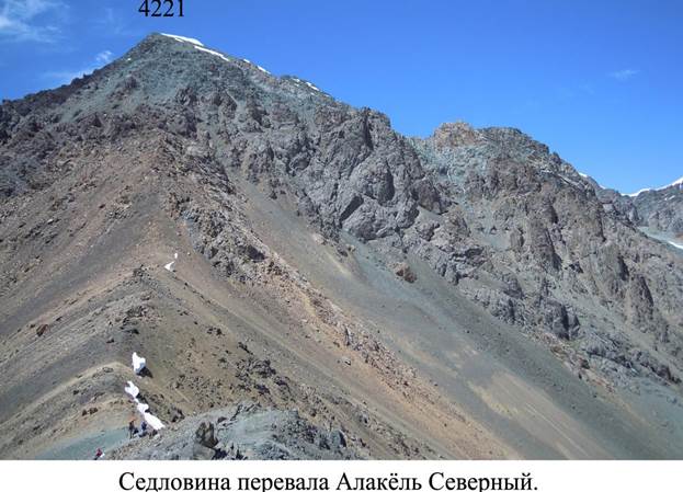
The trail gradually turns to the pass. Crossing the scree in ridges, it periodically descends and rises, but the general nature of the rise is the traverse of the scree slope with a small climb. Almost all the time the trail goes under the rocks, crossing scree in their upper part. About 10-15 minutes before the pass we leave for a local flattening - the scree here is larger, the path on it is lost, the path is marked with tours. We rise to the pass in 1 hour 10-20 minutes from the fork in the paths with one 10-minute halt. The saddle of the pass 16 is wide, scree, with the remains of snow cornices hanging from it. These are the only sections of snow on the take-off on both sides of the pass, dry. To the east there is a view of the headwaters of the Keldyke River.
Gathered on the pass, we admire the magnificent views of the lake, the surrounding peaks and glaciers. Height 3920 m. At 13:55 we start the descent from the pass. We do not go down to the camp, but to the shore of the lake (after about 20 minutes of descent along the path we leave it and, according to one of the screes, we go down to the water). Here, on a green terrace with a brook, we get up for lunch, finding a dry place (the shore of the lake is swampy). They went down here from the pass for 30 minutes.


2. Panoramic pass 1B 3700 (1A 3500) ???
Rise 5: 00-5: 30, exit at 7:15. Cloudy, completely calm, temperature + 8 °. The water in the lake is like a mirror; by the time of release a slight breeze rises. The trail to the Panoramic pass goes at a distance of a couple of tens of meters from the water with a traverse of the talus slope, marked by turiks. After 10 minutes, when overcoming rocky outcrops, it is divided into several, which then converge again. Suddenly, in front of the pass circus, a massive rockfall descends: large stones fly along one of the sidelines from the ridge line to the water and, reaching the lake, raise giant fountains. Alarmed, we quickly pass the rest of the trail under the rocks and make a halt at the entrance to the talus pass of the pass. Further ascent to the pass passes along medium and small scree with plots of land, steepness up to 20 °. In some places there is a trail, the scree is mostly stable. We leave for the pass at 8:45. It is windy, cool (+ 8 °), the panorama is hidden by clouds. We walk along a wide ridge in an easterly direction. There is no note on the tour. Many participants are slightly "minced." We start the descent at 9:35 diagonally to the right to reach the wide talus slope of the southern slope. 30 years of the Komsomol. Under the feet there is a small mobile scree, there is a kind of trail. We pass the beginning of a rocky and talus corridor, along which sometimes an ascent to the pass passes from the southwest, we descend 70 meters along the crest bordering the corridor on the right (the remains of the path), then again we go to the right, onto a wide slope, choosing areas of smaller talus. Next, we descend along this slope to the grass in a dense group, laying serpentines 35 minutes from the pass. The steepness of the slope is up to 25 °, the drop in altitude is 350 m. With the beginning of the descent, the weather improves, the sun comes out, gradually stretches the clouds. You can spend the night in the circus, but you will have to look for water closer to the port side. We begin the descent from the circus along the grassy slopes of the ancient moraines, first down, then going to the left side of the gorge. There is no good path, there are stones in the grass in places, it is not very convenient to walk. In 20 minutes we leave on a grassy shelf (shoulder) above a steep grassy slope that goes to the Keltor River. We decide to go down not directly along the stream, but with an oblique traverse to the left, in the direction of the upper Keltor. After a few minutes of descent from the shelf on the grass to 20 ° we find an old, weak path, leaving in the right direction. In some places it is lost, but then it is again. The trail noticeably facilitates the path. After 20 minutes of descent we cross two shallow dry sais, then the path again becomes more pronounced before entering the forest, however, judging by the sticking branches of fir and juniper, cattle are not driven for a very long time. In a rare forest, the path descends with a gentle serpentine and leads to a clearing overgrown with burdocks and sorrel near a dilapidated bridge over Keltor. When moving in the opposite direction, it is very desirable to find this path, which can be difficult: its beginning from the river is poorly read. The descent is clearly visible from the Telety valley. In 15 minutes we reach the glade by the river along the familiar road from under the Black Stones pass and set up a camp on it.
Travel time from border to forest border: 5-6 hours, in winter: 5-8 hours
History and date of ascent: the pass was first passed by Irkutsk tourists during an expedition to classify the passes in October 1970. The pass was named after the first letters of the members of the detachment that examined the pass: Bukhaltseva G., Yegorov Yu., Pelageykin V.N., Kukushkin V. N. (hands), Antipiev G.N., Nemchenko M.I.
Special equipment: main rope
The pass is one of the most popular and reliable passes through the GVH, often used to enter or exit the route in conjunction with the lane. Dinosaur (1A).
The pass is located in the right circus of the main stream (Barun-Handagay river). The approach to the lake, located at the foot of the lane. A dinosaur runs along the stream along talus and swamps with overcoming moraines. Above the lake, you can continue moving along the channel of the stream flowing out of the circus, or you can go sharply to the left (100-150 m, up to 25-30 ° to the moraine and traversing the inclined plateau, folded by flattened bedrock, go under the pass. The saddle is expressed very clearly - it is an oval talus saddle sandwiched by rocky peaks. A pass take-off of 80-100 m length and a slope of 30-35 ° passes along the medium-talus slope and leads to the saddle. The rise time from the forest border is about 2-3 hours.
The saddle of the pass is wide, scree. Tour in the center. Well visible p. SOAN, per. Snowy (1B), per. Dinosaur (1A).
A rock discharge is located directly under the saddle, therefore, for descent, you need to go to the right with a traverse of 40-50 m (the path is read), and then down the talus lane, sandwiched by the rocks. The steepness of the couloir is 25-30 °, the length is about 100 m. And then to the lake located at the bottom of the circus along the long talus slope (about 400 m, up to 35-40 °). The duration of the descent is about 1 hour.
From under the pass, movement along the moraines along the right stream to the border of the forest is about 40-50 minutes.
From the r. The bilyuta pass is located on the left (along the way) between the peaks almost at the circus circuit. The saddle is trapezoidal, expressed unambiguously.
In winter, ski pass approach. The approach and ascent to the pass itself is practically not an avalanche hazard. When leaving the saddle, stick to the scree on the left (along the way).
Descent and traverse towards Billiota is potentially avalanche hazardous. The movement here must be carried out in compliance with all measures of avalanche safety along the rocks.
A potential avalanche is also dangerous to roll out from under the pass - here there were cases of the disappearance of powerful side avalanches practically in the forest zone.
The pass time in the winter can increase by 1-2 hours.
Description provided by L.E. Shooter.
In sports tourism, a pass is a logical place for a given route to go over the dividing line of the ridge. Thus, in sports tourism, the pass is not always the lowest and most accessible place in the crest of a mountain range or massif.
Many sports passes do not pass through the lowest place in this part of the ridge, simply because nearby (higher along the ridge) is a simpler and safer path, for example, bypassing difficult rocks and rock-hazardous sections of the route.
There are many sports passes that, from the layman's point of view, look like madness: next to them there is a simple convenient trail through the ridge, and tourists climb onto “sheer cliffs”. Such passes are held in order to improve sportsmanship and prepare for more difficult hikes without traveling outside the easily accessible mountain areas. A large number of such passes in recent years have been covered on the Kola Peninsula, the Urals.
Pass classification
In sports tourism, passes are classified according to difficulty categories, which reflect the difficulty of the pass when passing by tourists. The category of difficulty is determined by the assessment based on several signs characterizing the degree of accessibility of the pass: altitude, the steepness of the slopes, the nature of their surface, the techniques used to pass the pass, and the conditions of the overnight stay. There are 3 categories of difficulty, each of which is divided into semi-categories A and B. Passes of category 1-A are considered the simplest, 3-B are the most difficult. Passes, the complexity of which is lower than 1-A, is usually classified as non-categorical. The passes, the difficulty of which can increase by half category depending on weather and other conditions (snowfall, sudden icing of slopes, etc.), are additionally classified as an asterisk. For example, 2-A *.
In the “List of classified high mountain passes” and “List of classified high mountain passes” for each pass, its location, name, altitude, category of difficulty for different seasons, rivers and glaciers on both sides of the pass, characteristics of passage, obstacles, and dangers are indicated. The difficulty category for each pass is periodically reevaluated by a specially created commission.
Table for assessing the difficulty of passes
| Category | Nature of the way | Overcoming Technique | Time to overcome. Number of points insurance, N. The length of the plot, L. |
Required Equipment |
|---|---|---|---|---|
| 1A | Simple talus, snow and rocky slopes with steepness up to 30 °; Flat (up to 15 °) glaciers without cracks; Steep grassy slopes on which sections of rock are possible; Usually the presence of trails on the approaches. |
The simplest individual technique of movement; Self insurance with an alpenstock or ice ax. For river crossings, approaches may require rope insurance. Overnight stays are usually in a forest or meadow zone. |
Few hours N \u003d 0 L \u003d 0 |
Shoes with non-slip soles, alpenstocks, safety belts (chest harnesses) and carbines for each participant. 1-2 main ropes per group. |
| 1B | Uncomplicated rocks; Snowy and scree slopes of medium steepness (from 20 to 45 °), and in some years, sections of ice on the slopes, usually covered with snow; Open glaciers with areas of hidden cracks |
The simplest collective technique: simultaneous movement in bundles along slopes and closed glaciers. A portion of the railing on the slopes and at crossings. Overnight stay is possible on the border of the glacial zone. | No more than one day N L | Boots with grooved soles, alpenstock or ice axes (1-2 ice axes per group are mandatory), safety systems and carbines for each participant. Hooks rock and ice (3-4 per group), rock or ice hammer. One main rope for every 3-4 people. |
| 2A | Rocky, snowy, ice slopes of medium steepness (from 20 to 45 °); closed glaciers and uncomplicated icefalls. | More complex individual and collective techniques: alternating or group (rail) insurance, the use of “cats” or cutting steps; hook insurance may be required. Accommodation is possible in the glacial zone. | No more than a day N \u003d 5–10 L 2-3 ropes in a row |
In addition to those listed for passes 1B: ice axes and cats for each participant, hooks in the required quantity and assortment. One main rope for every 2-3 people. |
| 2B | Steep (\u003e 45 °) snow, ice and rocky slopes of medium complexity, short (up to 10–15 m) wall sections are possible; icefalls of medium complexity. | The use of the most common arsenal of technical methods: handrail or alternate insurance, the use of hooks; the movement of the former on the rise, and the latter on the descent without a backpack, separate ascent and descent of the backpacks; descent along the rope with a rake. As a rule, overnight stays in the glacial zone are inevitable. | Not less than a day N \u003d 5–20 L 3-5 ropes in a row |
In addition to those listed for passes 2A: braking devices for lowering the rope and (preferably) clamps for lifting. Auxiliary rope, loops, expendable ends of ropes and hooks for lowering. |
| 3A | Steep (45 ° - 65 °) snow, ice and rocky slopes of considerable length; wall sections up to 1-2 ropes in a row; complex icefalls. | The use of various methods of movement and insurance in long sections, including the use of artificial supports, ladders, anchors, etc. Usually, preliminary reconnaissance and route processing is necessary. Tactics are gaining predominance. Repeated overnight stays in the ice zone are inevitable. Organizing a bivouac can require a lot of time and effort. |
Up to two days N \u003d 10–40 L | In addition to the equipment listed above, clamps for climbing rope; it is possible to use the main and auxiliary ropes of increased length; it may be necessary to use ladders, bookmarks and hooks to be removed during the descent. |
| 3B | The same as for 3A, but with a large length of complex sections, their diverse nature or extreme complexity, including walls with a steepness of 60 ° or more. | The need for almost continuous group insurance for many hours and even days; special, designed to overcome this pass, training; excellent knowledge of technology by all participants; flawless tactics. Perhaps the lack of places for overnight stays, which requires the organization of "sedentary" or "hanging" bivouacs. |
Not less than two days N\u003e 30 L\u003e 500 m \u003e 10 ropes in a row |
Same as for 3A. Equipment may be required that is specially prepared to overcome a particular pass. |
Notes:
* Under the insurance points are meant the places of fastening and etching of the rope with the help of an ice ax, hooks with carabiners, rock ledges, ice columns, over the shoulder, lower back, etc., necessary for hanging the railing and for insurance going first on the rise and the last during the descent.
* The presence of potentially hazardous areas (rockfalls, avalanches, ice landslides) does not affect the category of difficulty of the pass and should be taken into account in the tactics of passage and in the selection of equipment.
* For passing passes of any category of difficulty in winter conditions or with deep snow on the slopes, it is additionally required to have avalanche cords (20 m) for each participant and avalanche shovels, one for every 2-3 people.
The number of difficulty categories in all types of active tourism is 6. With an increase in the complexity category of a hike, its difficulty increases from I to VI (table 1). The complexity category of a route is determined by local obstacles encountered in its path. In trekking (mountain tourism) - these are passes, in water tourism - rapids, in caving - caves, etc. In turn, local obstacles can also be divided into several categories of difficulty. The difficulty category is used in the context of the trip in general, and the difficulty category is used for local obstacles on the tourist route.
Table 1 - Standards hiking in active tourism
| Difficulty category | I | II | III | IV | V | VI |
| Minimum duration in days | 6 | 8 | 10 | 13 | 16 | 20 |
| Type of tourism | The minimum length of the trip, km | |||||
| Trekking (mountaineering) | 100 | 120 | 140 | 150 | 160 | 160 |
| Bicycle | 300 | 400 | 500 | 600 | 700 | 800 |
| Water | 150 | 160 | 170 | 180 | 190 | 190 |
| Speleo (number of caves) | 5 | 4-5 | 1-2 | 1-2 | 1-2 | 1 |
| Pedestrian | 130 | 160 | 190 | 220 | 250 | 300 |
| Ski | 130 | 150 | 170 | 210 | 240 | 300 |
In tracking, the trekking route should be linear or circular and make up at least 75% of the entire route. This is done so that if there is a shortage of distance for offsetting in the IWC, tourists can make radial exits. "Radialka" counts in one direction if the return is on the same path.
The difficulty of climbing in mountaineering is determined by the complexity of a particular route to the mountain peak. There are also 6 categories of complexity, divisible by 2 semi-categories A and B (1A KS in mountaineering is not included in the offset of the category). The difficulty categories of the route are determined by the difficulty of local sections, which are also 6 from I to VI. There is an international methodology for assessing the difficulty of rocky areas UIAA - Union of International Mountaineering Associations. The classification is presented 11 k.t. from I to XI. You can see it.
In tracking, local obstacles are mainly passes (table 2). The main categories are 3, divided into semi-categories as well as in mountaineering - A and B. There are passes without ct. - uncategorized (n / a are indicated on the maps). In the offset of the trekking trip you can include traverses and climbing peaks. Here it is necessary to correctly translate the climbing category of difficulty into trekking. Approximately it looks like this:
- the nature of the most difficult sections of the pass;
- the equipment necessary for overcoming the pass, tactics of movement and especially the places of overnight stays;
- quantitative characteristics (travel time, number of insurance points);
- necessary special equipment ( Popchikovsky V.Yu.).
In offset of a route any k.s. several passes are included (table 2). The minimum number of passes of one or another difficulty is established. At the same time, the maximum number of passes in one route can be increased by 2. A tourist group may include passes of any difficulty not exceeding the complexity of the trip. It is worth noting that, starting from the campaign of the 3rd cc, the group has the right to decide for itself which pass is more logical to pass.
Table 2 - the standards of the category of difficulty hiking in tracking
| Campaign difficulty category | ||||||
| I | II | III | IV | V | VI | |
| Minimum number of passes | 2 | 3 | 4 | 5 | 6 | 7 |
| The difficulty of the passes | ||||||
| 1A | 2 | 1 | ||||
| 1B | 2 | 1 | 1 | |||
| 2A | 2 | 1 | 1 | |||
| 2B | 2 | 1 | 1 | |||
| 3A | 2 | 1* | ||||
| 3B | 2* | |||||
* on route VI possible per. 2B - 1 pc., 3A - 3 pc., 3B - 1 pc.
The complexity of the passes is determined as follows (table 3).
Table 3 - Criteria for assessing the difficulty of passes
(Table from the book "Russian tourist. Regulations on sports and recreational tourism in Russia for 2001-2004.")
| K.t. the pass | The nature of the most difficult sections of the path | Technique and conditions of movement | Total time (t) to overcome the pass. Number of insurance points (n). The length of the defining section (I) | Special equipment required |
| 1A | Simple, talus, snowy and rocky slopes with a slope of up to 30 ° shallow (up to 15 °) glaciers without cracks are steep grassy slopes on which rock sections are possible, usually there are trails on the approaches. | The simplest individual technique of movement is self-insurance with an alpenstock or ice ax. For river crossings, approaches may require rope insurance. Overnight stays are usually in a forest or meadow zone. | A few hours. N \u003d 0I \u003d 0 | Shoes with non-slip soles, alpenstocks, safety belts (chest harnesses) and carbines for each participant. 1-2 main ropes per group. |
| 1B | Uncomplicated rocks, snowy and scree slopes of medium steepness (from 20 to 45 °), and in some years also ice sections on slopes, usually covered with snow: closed glaciers with areas of hidden cracks. | The simplest collective technique: simultaneous movement in bundles along slopes and closed glaciers. A portion of the railing on the slopes and at crossings. Overnight stay is possible on the border of the glacial zone. | Not more than one day. N \u003d up to 5I \u003d up to 40-50 m. | Boots with grooved soles, alpenstocks or ice axes (1-2 ice axes per group are mandatory), safety systems and carbines for each participant. One main rope for every 3-4 people. Hooks rock and ice (3-4 per group), rock and ice hammer. |
| 2A | Rocky, snowy, ice slopes of medium steepness (from 20 to 45 °) are closed glaciers and uncomplicated icefalls. | More complex individual and collective techniques, alternating or group (railing) insurance, the use of cats or wheelhouse steps may need hook insurance. Accommodation is possible in the glacial zone. | Not more than a day n \u003d 5-10I \u003d up to 80-100 m. (2-3 ropes in a row) | In addition to the above for passes 1B kt ice axes and “cats” for each participant, hooks in the required quantity and assortment. One main rope for every 2-3 people. |
| 2B | Steep (over 45 °) snow, ice and rock slopes of medium complexity, short (up to 10-15 m.) Wall sections of icefall of medium complexity are possible. | The use of the most common arsenal of technical methods: handrail or alternate insurance, the use of hooks, the movement of the former on the rise, and the latter on the descent without a backpack, separate lifting and lowering of backpacks rope descent (rappel). As a rule, overnight stays in the glacial zone are inevitable. | Not less than a day.n = 5-20I \u003d up to 200 m (3-5 ropes in a row) | In addition to the 2A grade listed for passes, there are: braking devices for rope descent and (preferably) lifting clamps. Auxiliary rope, loops, expendable ends of ropes and hooks for lowering. |
| 3A | The steep (from 45 to 65 °) snow, ice and rock slopes of considerable length wall sections up to 1-2 ropes in a row are complex icefalls. | The use of various methods of movement and insurance in long sections, including the use of artificial supports, ladders, anchors, etc. Usually, preliminary reconnaissance and route processing is necessary. Tactics are gaining predominance. Repeated overnight stays in the ice zone are inevitable. Organizing a bivouac can require a lot of time and effort. | Up to two days n \u003d 10-40I \u003d 200 to 500 m. (Up to 10 ropes in a row) | In addition to the equipment listed above, clamps for climbing the rope, it is possible to use primary and auxiliary ropes of increased length; you may need to use ladders, bookmarks and hooks that are removed during the descent. |
| 3B | The same as for 3A, but with a greater length of complex sections, their diverse nature or extreme complexity, including walls with a steepness of 60 ° or more. | The need for almost continuous mutual and group insurance for many hours and even a special day, designed to overcome this pass, to prepare excellent command of the technique by all participants in impeccable tactics. There may be no places for sleeping, which requires the organization of sedentary or hanging bivouacs. | Not less than two days. N ≥ 30I \u003d 500 m. And more (more than 10 ropes in a row) | Same as 3A ct. May require equipment specially prepared to overcome a particular pass. |
The criteria for evaluating routes to the mountain peaks include:
- absolute height of the peak;
- the length of the route;
- the steepness of the slopes, the nature of the relief;
- technical complexity of individual sections;
- the total number of sites of varying degrees of difficulty on the way to the top;
- approaches and descent from the top are not included in the category of difficulty of the route.
In general, they are similar to the assessment of passes. The complexity of climbing routes is determined as shown in tables 4 and 5.
Table 4 - Criteria for assessing the complexity of routes to the mountain peaks
| K.S. peaks | The nature of the slopes | The difficulty category of sections along the route (for more details about CT, see the table below). | Total time (t) to overcome the peak. Number of insurance points (n). |
| 1B | Rocky / snow-ice or combined route, peaks up to 5000 m high. The average length of the route is 500 m, the average steepness is 10-25 °. | The basis is 0 kt It is necessary to have a plot of I c.t. (rocky: 20-30 m or more, or ice-snow: 80-100 m or more) or the presence of several sections of II c.t. (each - 3-15 m of rocky or 30-40 m of ice-snow nature). | t from 1.5 to 8 hours n \u003d 0+ |
| 2A | The basis is sections 0 and I c. It is necessary to have a plot of II KT (rocky: 5-20 m, or ice-snow: 80-100 m). | t from 2 to 10 hours n \u003d 0+ | |
| 2B | Rocky / snow-ice or combined route, peaks up to 6000 m high. The average length of the route is 550 m, the average steepness is 15-30 °. | The basis is sections 0 and I c. It is necessary to have a plot of II k.t. (rocky: 15-30 m or more, or ice-snow: 80-100 m or more) or the presence of several sites of III grade (each - 3-10 m of rocky or 20-50 m of ice-snow nature). | t from 2 to 10 hours n \u003d 0-3 |
| 3A | The basis is made up of sections I and II k.t. It is necessary to have a plot of III grade (rocky: 5-20 m, or ice-snow: 50-200 m). | t from 3 to 10 hours n \u003d 1-3 Rope descent possible. | |
| 3B | Rocky / snow-ice or combined route, peaks up to 6500 m high. The average length of the route is 600 m, the average steepness is 20-40 °. | The basis is made up of sections I and II k.t. It is necessary to have a plot of III k.t. (rocky: 20-30 m, or ice-snow: 100-300 m) or the presence of several sites IV grade (each - 3-15 m of rocky or 50-100 m of ice-snow nature). | t from 3 to 10 hours n \u003d 2-6 Rope descent. |
| 4A | The basis is made up of sections II and III k.t. It is necessary to have a plot of IV grade (rocky: 20-50 m, or ice-snow: 50-200 m). | t ≥5 h. n \u003d 10-15 + It may be necessary to arrange overnight on the route. The descent along the rope. | |
| 4B | Rocky / snow-ice or combined route, peaks up to 7000 m high. The average length of the route is 650 m, the average steepness is 30-50 °. | The basis is made up of sections II and III k.t. It is necessary to have a plot of IV grade (rocky: 40-80 m, or ice-snow: 200-400 m) or the presence of several sections of V k.t. (each - 3-15 m of rocky or 50-150 m of ice-snow nature). | t ≥6 h. n \u003d 10-20 + In most cases, organization of an overnight stay on the route will be required. The descent along the rope. |
| 5A | Rocky / snow-ice or combined route, peaks up to 7500 m high. The average length of the route is 700 m, the average steepness is 40-60 °. | The basis is made up of sections III and IV k.t. It is necessary to have a plot of V KT (rocky: 10-40 m, or ice-snow: 100-400 m). | t ≥6 h. n \u003d 15-20 + In most cases, organization of an overnight stay on the route will be required. The descent along the rope. |
| 5 B | Rocky / snow-ice or combined route, peaks more than 2000 m high. The average length of the route is 750 m, the average steepness is 45-70 °. | There are practically no plots of I and II k.t. The basis is made up of sections III and IV k.t. It is necessary to have a plot of V k.t. (rocky: 50 m, or ice-snow: 300-500 m) or the presence of several sections of VI c.t. (3-20 m each). | t ≥8 h. n \u003d 40-50 + In most cases, it will require a technically complicated organization of the overnight stay on the route. Descent only by rope. |
| 6A | Rocky / snow-ice or combined route, peaks more than 3000 m high. The average length of the route is 800 m, the average steepness is 65-75 °. | There are practically no plots of I-III c.t. The basis is sections IV and V c. It is necessary to have plots of VI grade (each 20–40 m or more), with a total length of at least 200 m. | t ≥3 days n \u003d 100 + A technically complicated organization of the overnight stay on the route is required (mainly seating or hanging places). Descent only by rope. |
| 6B | Rocky / snow-ice or combined route, peaks more than 3,000 m high. The average length of the route is 800 m, the average steepness is 70-80 °. | Virtually no sites I-IV KT The basis is plots of V and VI c.t. | t ≥3 days n \u003d 100 + Technically difficult organization of an overnight stay on the route is required (mainly hanging hammocks, etc.). Descent only by rope. |
| K.T. | The nature of the sites | Passing technique |
| 0 | Snow-ice, rocky slopes and ridges with a steepness of 10-20 °. | Sites are traversed by the simultaneous movement of the entire group. |
| I | Snow-ice sections with a steepness of 15-30 °, non-steep cliffs. | The plots are traversed by the simultaneous movement of the entire group, using hands to maintain balance. |
| II | Snow-ice sections with a steepness of 25-30 °, non-steep rocks. | The sections are held alternately, and by experienced climbers - simultaneously, using hands to maintain balance. |
| III | Snow-ice sections with a steepness of 30-45 °, steep cliffs with numerous hooks and protrusions, or gentle but smooth rocks. | Rocky sections are “free climbing”, with the main load on the legs and a backpack on the shoulders. Snow-ice sections are carried out by the technique in "three measures" or in cats. |
| IV | Snow-ice sections (slopes and ridges with snow cornices) with a steepness of 40-55 °, steep cliffs with a few hooks and ledges. | The rocky sections are “free climbing”, the passage with a backpack on the shoulders is possible, but very difficult. Snow-ice patches pass mainly on the front teeth of cats. |
| V | Snow-ice sections (slopes and ridges with snow cornices) with a steepness of more than 45 °, steep cliffs with inconvenient few hooks and ledges. | The rocky sections are "free climbing" or with the setting of artificial points of support (ITO). Walking with a heavy backpack on your shoulders is not possible. Snow-ice patches pass mainly on the front teeth of cats, but mainly with the setting of ITO. |
| VI | Rocky vertical walls and overhangs with uncomfortable, few hooks and ledges. | Passing sites requires effort to the limit of human capabilities. |
There is no official assessment of backcountry routes in the post-Soviet space. The backcountry difficulty category is closely intertwined with the complexity of climbing and hiking routes (table 6).
Table 6 - Assessment of the complexity of backcountry routes ( Vitaliy rage)
| K.S. route | Difficulty (rating) of descent (ski)* | Mountaineering analogue | Medium grade and terrain | Descent features and degree of danger |
| F -Simple | 1, 2.1, 2.2 | n / a, flat | ≤28 o, hilly terrain without obstacles. | Lack of key areas, risk of loss of control and fall. |
| PD – Not very difficult | 2.1-3.2 | n / k, cooler | 28-35 about, open spaces with small sections of steep terrain. Skating in the forest. Not very steep and short contractions. | Turns are possible to overcome obstacles. Steep sections with a good roll out. |
| AD - Medium | 3.2-4.3 | 1A, 1B | 35-40 about, steep sections are inevitable. Short and very steep contractions. | The need for short turns. Risk of injury due to loss of control. Overcoming obstacles requires a quick response. |
| D – Complex | 4.2-5.2 | 2A-3A | 40-45 about, a steep slope, rocks, cliffs, ice. | Short turns are still possible. Many obstacles that require excellent equipment skills. If you fall, death is possible. |
| TD – Very difficult | 5.3+ | 3B-4B (5A) | 45-50 about, a very steep slope, a lot of rock faults, steps, cliffs, large cracks. | Partially necessary are short turns and crawls along long steep sidelines. Possible descent dyuferom. If you fall, death is likely. |
| ED (EX) - Extreme | 5.4+ | 5A and higher | 50-55 о, steep walls and sidelines, rock steps, faults, cliffs, large cracks. | Short turns and crawls along long steep sidelines are needed. The passage through the cliff of rock walls. Lack of safe stopping points |
Methods for categorizing other types of active tourism can be found in detail in this book on pages 86-115. Vostokov I.E., Panov S.N. Russian tourist. Regulations on sports and recreational tourism in Russia for 2001-2004. - M., 2001. Download .
Officially, the passage of routes can be issued at Federation of sports tourism and tourist all-around, we have such . On the site you can find various information on tourism and sporting events for active types of tourism: competitions, tours, festivals, water regattas, etc. throughout Kazakhstan. But this, if you want to become an athlete, if not, then join us.