Khosta fortress. We continue our walk along the Big Boxwood Ring
I continue my photo story about a walk through the Yew-Boxwood Grove in Sochi (you will find the beginning of the walk and information on how to get to this attraction in Khosta).
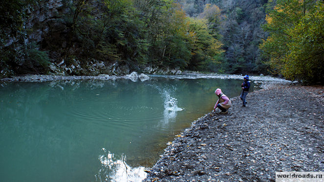
Today you will see Ancient fortress, Khosta river and spring (Khosta, Sochi).
True, now we have come across a fork in the road:

— if you go up, you can reach the ruins of the Ancient Fortress;
- and the road, going a little to the side, will lead to a river and a spring.
Its official name is Khosta Fortress. It was built around the 8th-10th century AD. Its second name is Genoese fortress.

The fortress itself today represents the remains of an ancient structure, presumably for defensive purposes. It is located, if you look at the map, in the northeastern part of the reserve "", above the river on the right bank of Khost, 6 km from the Black Sea. The right bank of the Khosta River here goes down in a 100-meter cascade of cliffs (therefore it is better not to approach the edge, so as not to add work to the rescuers). The top of the cliff above the Khosta shore is also the top of a rather significant downward slope in the other direction.
I'm not sure, but it seems that there are remains of towers and several fragments of a wall made of limestone with lime mortar.


To be honest, at first I didn’t even understand why the fortress was located in such a strange place- in the middle of the forest.

Then I realized that several centuries ago there might not have been a forest here, but the river below was very clearly visible. If we assume that the Khosta River at that time was navigable (for ships of those times), then from such a fortress it was very convenient to control the movement of both friends and enemies along the river.
....We return to the main trail and go down to the river. Be careful not to push small pebbles down from the path with your feet - they may fall on people walking along the river bank:

And here she is river:


The road to the spring is very picturesque, as it passes along the rocks along the river:


The rich history of this area and the reverent attitude of the inhabitants towards it allows you to see centuries-old buildings that, by some miracle, are still intact. One of them includes the Khosta fortress, or as it is otherwise called, the Genoese fortress.
Surprisingly, not a single scientist has yet turned his attention to this amazing structure. And since no serious research has been carried out, the history of this place can be called more of a legend or speculation.
According to one of the versions, which is the most common, the building belonged to the Genoese. On the maps of this people a place called Costa was marked. However, no logical reasons could be found for why the fortification was located so far from the sea. Despite this, the second name of the fortress is Genoese.
A more plausible assumption is that the fortress belongs to the Turks. These people tend to defend territory in this way, and local population could well have asked for protection.
Extant buildings
The building is located 6 km from the sea, in the valley of the Khosta River. I must say that from a strategic point of view the location was chosen perfectly. It is surrounded on two sides by steep cliffs, and on the other two by towers. Four of them have survived. The height, area and degree of destruction are different.The first tower has been preserved well - the nearby gates are visible, and you can also guess the loophole from where the brave soldiers could shoot, defending the territory.
The second, located several tens of meters away, is badly damaged. Therefore, its role in defensive actions is difficult to understand. There is an assumption that its height was more than 5 m, but there is no evidence of this.
The third tower is the most destroyed of all. It has an impressive base area, but it is impossible to make assumptions about its size. It is located ten meters from the second one.
The last, fourth tower, was, in all likelihood, the main firing line. The walls, whose height is 11 m, have survived, and several levels of loopholes are clearly visible, which allowed a small detachment to shoot back from enemies.
Terrain
You can repeat many times the dates and names that local guides have memorized over the years. However, the unique nature of this place will be no less valuable for tourists. The rare plants that can be found here have managed to become friends with the destroyed walls of the fortress. When you get here, you find yourself in fairy tale world, which enchants. Walking along the paths of the forest, you can feel not only the breath of history, but also magic.(function(w, d, n, s, t) ( w[n] = w[n] || ; w[n].push(function() ( Ya.Context.AdvManager.render(( blockId: "R-A -142249-1", renderTo: "yandex_rtb_R-A-142249-1", async: true )); )); t = d.getElementsByTagName("script"); s = d.createElement("script"); s .type = "text/javascript"; s.src = "//an.yandex.ru/system/context.js"; s.async = true; , this.document, "yandexContextAsyncCallbacks");
We continue our walk along the Big Boxwood Ring.
We have already covered half the route. We walked through a very beautiful and unusual forest. But the most picturesque views are ahead, in the gorge.
Khosta fortress and the Khosta river
After Beech Glade we came to the ancient Khosta fortress, which existed here in the early Middle Ages, in VIII-X centuries ad.

Its ruins are nestled on a rock near a cliff. Fragments of the wall and the remains of the towers are covered with ivy and trees grow right on them. Access to the fortress is prohibited. Yes, he is unsafe. It is inaccessible on three sides due to cliffs and steep cliffs.

The location of the fortress raises many questions, since these areas were previously unsafe. In the valleys mountain rivers There were mosquitoes in the Black Sea, and because of them, people got fever and died. How the defenders of the fortress lived in such conditions is a mystery...

Well, for me, the mystery is the different dating of the fortress in different sources. Wikipedia, of course, is not such a reliable source. But even on the shield near the fortress itself, different things are written: sometimes the 7th-10th, sometimes the 8th-10th centuries. Although just think, a century earlier, a century later. It’s still poorly preserved... You can only see what it was like before in the picture on the information board. Admire!

After the fortress, the descent begins along a 100-meter cliff to the Khosta River. It is half a kilometer from the fortress.

The descent is a steep serpentine road and is fenced with chains.


Brief rest

And again - on the road...
The river is visible through the trees below.

Here she is, Khosta - down there

Hosta is very beautiful.

The water is an amazing turquoise color, and there are white stones along the banks.


After a short walk along the bank of Khosta, we moved on. There are still 800 meters left to the spring.


Some rocks seem to be made of bricks.

The rocks seem to be made of bricks...
I especially liked this part of the route. Very picturesque views. I stopped and took pictures all the time. Views of the gorge, the turquoise river below, strange trees hanging over the path.

In the most difficult places - hanging balconies, metal decking.

It's not at all scary to go. Everything is fenced. Feeling completely safe.

Although, you know, at the top we often saw signs: “Dear visitors! Do not throw stones or foreign objects! There are people below!

And below we saw warnings: “Possible rockfall!”

Well, this is how they would write: “Perhaps stones and foreign objects can still be thrown from above!” 🙂

Spring and cave
Surprisingly, the Spring turned out to be quite large.

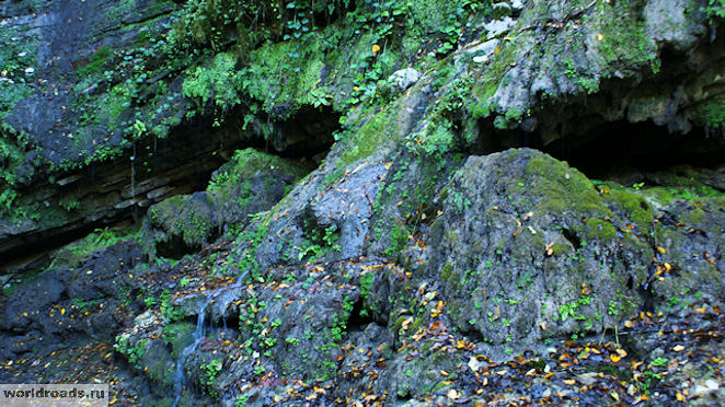
Next to it, a small waterfall, modest in autumn time, falls down from the cliff.

Waterfall

The same waterfall from above
The cave is a separate issue.


Passage to the cave. Everything is securely fenced
A beautiful sign at the entrance, such an equipped approach with a steep staircase...

Eh, we’re already dreaming about stalactites and stalagmites...

And the climb doesn’t seem so steep anymore...
You go up - and there is another sign: “Entry into the cave is prohibited!” Both of us!.. Why did we climb here?

Cave in the Yew-boxwood grove
While going down, I suddenly heard a stone flying after me. Apparently, he fell from the arch at the entrance to the cave. Hmmm... And maybe it’s not for nothing that entry is prohibited?

And then we met a couple of tourists. They asked:
- How's the cave?
We said we didn't go inside.

Already near the entrance to the Small Ring we met these tourists again. It turned out that they had entered the cave. You can walk there about 10 meters, no more. And then - a collapse. There is nothing interesting in the cave. No stalactites, no stalagmites, not even bats...

And here is the staircase up several flights.

The wood was not interfered with during the construction of the stairs
Nearby is a tree swallowing a stone.

Tree swallowing a stone
Look, this forest giant has clearly visible eyes and mouth. And in the mouth there is a huge stone. This is probably how legends about forest monsters were born...

Forest giant with a stone in his mouth

And here is the Labyrinth Beam. The same one along which streams flow from Mount Bolshoi Akhun in the spring.

Labyrinth beam
It is a continuation of the rock Labyrinth that we saw at the beginning of the route. The end of the route is coming soon.

Here the Labyrinth Beam opens to the river
We walked the Big Boxwood Ring route in about three hours. With children and stops to take photographs.

But that is not all. After all, after the Big Ring we went along the Small Ring. But more about him next time.
Well, how do you like a walk along the Great Ring of the Yew and Boxwood Grove?
© Galina Shefer, “Roads of the World” website, 2014. Copying text and photos is prohibited. All rights reserved.
—————
Related posts:
(function(w, d, n, s, t) ( w[n] = w[n] || ; w[n].push(function() ( Ya.Context.AdvManager.render(( blockId: "R-A -142249-2", renderTo: "yandex_rtb_R-A-142249-2", async: true )); )); t = d.getElementsByTagName("script"); s = d.createElement("script"); s .type = "text/javascript"; s.src = "//an.yandex.ru/system/context.js"; s.async = true; , this.document, "yandexContextAsyncCallbacks");Khosta fortress(the name Genoese fortress is also found) - the remains of an ancient structure, presumably defensive fortress, in the northeastern part of the Yew-Boxwood Grove nature reserve, above the river on the right bank of Khost, 6 km from the Black Sea. The right bank of the Khosta River here goes down in a 100-meter cascade of cliffs. The top of the cliff above the Khosta shore is also the top of a rather significant downward slope in the other direction. Along the river, perpendicular to it, the lower and upper boundaries of the structure do not have steep cliffs, but movement is hampered by the downward slope in the other direction from the river.
By 2010, the remains of 4 towers and several fragments of the wall, made of limestone with lime mortar, had been preserved. Old boxwoods and hornbeams grow right on the fragments of the walls, high above the ground.
It is located in a hard-to-reach part of the park due to cliffs and rock falls and rock fragments. On the road to the remains of the structure, the park administration posted signs prohibiting passage and requiring people to return to a safe part. It is not recommended to visit the site alone - the road to it is dangerous.
History of the building
Current state of the building
Fragments of the wall and the remains of the towers, fastened with lime mortar, under open air Having stood for centuries, they are still strong. But several excavations made under the towers, apparently in the last decade, led to the appearance of a significant crack.
Tower on the southeast corner
The south-eastern corner of the fortress is protected by a tower, preserved to a height of up to 4.5 m. A loophole window measuring 40 X 50 cm looks out from the tower to the west. At the south-eastern corner there is a narvy gate.
Second tower
The second tower, 45 m from the first, has an irregular rectangular plan. In its western and eastern walls, two tiers of grooves from the beams of the interfloor floors are noticeable. The height of each floor is 1.7-1.8 m. The tower was apparently three stories high.
Third tower
Only 11 m of wall separates the second and third gate towers. It was poorly preserved. Its massif, occupying an area of 14 by 8 meters, pinches out at an acute angle to the southwest, forming a barrier to the fortress gates. The threshold of this gate is visible in the middle part of the corridor formed by the northern wall of the third tower, and a massive wall running parallel to it, which then stretches to the west. Above the threshold, at a height of more than 1 m, a groove is visible for securing the bolt bar.
Fourth inner tower
To the west of the gate, a tower-shaped buttress protrudes from the wall, protecting the gate. 10 m from it is last tower, which, unlike the others, also protrudes into the fortress. At the same time, its room is deepened into the thickness of the wall by more than 1 m. A doorway leads into the upper tier of the tower. Judging by the stone protruding from the wall here, on which the ceiling was supported, the height of this room reached 1.9 m. Taking into account the surviving fragments, one should think that the original height of the tower was at least 11 m. From its lower floor a wide loophole looks south.


