The Bering Sea is the ocean to which it belongs. Bering Sea: geographical location, description. Large islands of the sea
Bering Sea
The largest of the Far Eastern seas washing the shores of Russia, the Bering Sea is located between two continents - Asia and North America - and is separated from the Pacific Ocean by the islands of the Commander-Aleutian arc. Its northern border coincides with the southern border of the Bering Strait and stretches along the line of Cape Novosilsky (Chukchi Peninsula) - Cape York (Seward Peninsula), the eastern border runs along the coast of the American continent, the southern - from Cape Khabuch (Peninsula Alaska) through the Aleutian Islands to Cape Kamchatsky, western - along the coast of the Asian continent.
The Bering Sea is one of the largest and deepest seas in the world. Its area is 2315 thousand km 2, volume - 3796 thousand km 3, average depth- 1640 m, greatest depth - 4097 m. The area with depths of less than 500 m occupies about half of the entire area of the Bering Sea, which belongs to the marginal seas of a mixed continental-ocean type.
There are few islands in the vast expanses of the Bering Sea. Not counting the border Aleutian island arc and the Commander Islands, the sea contains the large Karaginsky Islands in the west and several islands (St. Lawrence, St. Matthew, Nelson, Nunivak, St. Paul, St. George, Pribilof) in the east.
The coastline of the Bering Sea is highly indented. It forms many bays, bays, peninsulas, capes and straits. For the formation of many natural processes of this sea, straits that ensure water exchange with the Pacific Ocean are especially important. Their total cross-sectional area is approximately 730 km 2, the depths in some of them reach 1000-2000 m, and in Kamchatka - 4000-4500 m, as a result of which water exchange occurs not only in the surface, but also in the deep horizons. The cross-sectional area of the Bering Strait is 3.4 km 2, and the depth is only 60 m. The waters of the Chukchi Sea have practically no effect on the Bering Sea, but the Bering Sea waters play a very significant role in the Chukchi Sea.

Boundaries of the Pacific Ocean
Different areas of the Bering Sea coast belong to different geomorphological types of shores. Mostly the shores are abrasive, but there are also accumulative ones. The sea is surrounded mainly by high and steep shores, only in the middle part of the western and east coast it is approached by wide strips of flat, low-lying tundra. Narrower strips of low-lying coastline are located near the mouths of small rivers in the form of a deltaic alluvial valley or border the tops of bays and bays.

Landscapes of the Bering Sea coast
Bottom relief
In the bottom topography of the Bering Sea, the main morphological zones are clearly distinguished: the shelf and island shoals, the continental slope and the deep-sea basin. The shelf zone with depths of up to 200 m is mainly located in the northern and eastern parts of the sea and occupies more than 40% of its area. Here it adjoins the geologically ancient regions of Chukotka and Alaska. The bottom in this area is a vast, very flat underwater plain 600-1000 km wide, within which there are several islands, troughs and small rises in the bottom. The mainland shelf off the coast of Kamchatka and the islands of the Komandorsko-Aleutian ridge looks different. Here it is narrow, and its relief is very complex. It borders the shores of geologically young and very mobile land areas, within which intense and frequent manifestations of volcanism and seismic activity are common.
The continental slope stretches from northwest to southeast approximately along the line from Cape Navarin to the island. Unimak. Together with the island slope zone, it occupies approximately 13% of the sea area, has depths from 200 to 300 m and is characterized by complex bottom topography. The continental slope zone is dissected by underwater valleys, many of which are typical underwater canyons, deeply cut into the seabed and having steep and even steep slopes. Some canyons, especially near the Pribilof Islands, have a complex structure.
The deep-water zone (3000-4000 m) is located in the southwestern and central parts of the sea and is bordered by a relatively narrow strip of coastal shallows. Its area exceeds 40% of the sea area. The bottom topography is very calm. It is characterized by an almost complete absence of isolated depressions. The slopes of some bottom depressions are very gentle, i.e. these depressions are weakly isolated. Among the positive forms, the Shirshov Ridge stands out, but it has a relatively small depth on the ridge (mostly 500–600 m with a saddle of 2500 m) and does not approach the base of the island arc closely, but ends in front of the narrow but deep (about 3500 m) Ratmanov Trench. The greatest depths of the Bering Sea (more than 4000 m) are located in the Kamchatka Strait and near the Aleutian Islands, but they occupy a small area. Thus, the bottom topography makes it possible for water exchange between individual parts of the sea: without restrictions within the depths of 2000-2500 m and with some limitation (determined by the cross-section of the Ratmanov Trench) to depths of 3500 m.

Bottom topography and currents of the Bering Sea
Climate
Geographical location and large spaces determine the main features of the climate of the Bering Sea. It is almost entirely located in the subarctic climate zone, only the northernmost part (north of 64° N) belongs to the Arctic zone, and the southernmost part (south of 55° N) belongs to the temperate latitude zone. In accordance with this, climatic differences between different areas of the sea are determined. North of 55-56° N In the climate of the sea (especially its coastal areas), continental features are noticeably expressed, but in areas far from the coast they are much less pronounced. To the south of these parallels the climate is mild, typically maritime. It is characterized by small daily and annual air temperature amplitudes, large clouds and significant amounts of precipitation. As you approach the coast, the influence of the ocean on the climate decreases. Due to stronger cooling and less significant heating of the part of the Asian continent adjacent to the sea, the western regions of the sea are colder than the eastern ones. Throughout the year, the Bering Sea is under the influence of constant centers of atmospheric action - the Polar and Hawaiian maxima, the position and intensity of which vary from season to season, and the degree of their influence on the sea changes accordingly. It is no less influenced by seasonal large-scale pressure formations: the Aleutian minimum, the Siberian maximum, and the Asian depression. Their complex interaction determines the seasonal characteristics of atmospheric processes.
In the cold season, especially in winter, the sea is influenced mainly by the Aleutian minimum, the Polar maximum and the Yakut spur of the Siberian anticyclone. Sometimes the impact of the Hawaiian High, which at this time occupies the extreme southern position, is felt. Such a synoptic situation leads to a wide variety of winds and the entire meteorological situation over the sea. At this time, winds from almost all directions are observed here. However, the northwestern, northern and northeastern ones noticeably predominate. Their total repeatability is 50-70%. Only in the eastern part of the sea, south of 50° N, are southern and southwestern winds quite often observed, and in some places even southeastern. Wind speed in the coastal zone averages 6-8 m/s, and in open areas it varies from 6 to 12 m/s, increasing from north to south. Winds from the northern, western and eastern directions carry with them cold sea arctic air from the Arctic Ocean, and cold and dry continental polar and continental arctic air from the Asian and American continents. With winds from the south, polar sea air and, at times, tropical sea air comes here. Above the sea, predominantly the masses of continental Arctic and marine polar air interact, at the border of which an Arctic front is formed. It is located slightly north of the Aleutian arc and generally stretches from southwest to northeast. At the frontal section of these air masses, cyclones form, moving approximately along the front to the northeast. The movement of these cyclones contributes to the strengthening of northern winds in the west and their weakening or even change to southern winds in the east of the sea. Large pressure gradients caused by the Yakut spur of the Siberian anticyclone and the Aleutian low cause very strong winds in the western part of the sea. During storms, wind speeds often reach 30-40 m/s. Usually storms last about a day, but sometimes they last 7-9 days with some weakening. The number of days with storms in the cold season is 5-10, in some places it reaches 15-20 per month.

Water temperature on the surface of the Bering Sea and Sea of Okhotsk in summer
Air temperature in winter decreases from south to north. Average monthly temperature the coldest months - January and February - is 1-4° in the southwestern and southern parts of the sea and -15-20° in the northern and northeastern regions. In the open sea the air temperature is higher than in the coastal zone. Off the coast of Alaska it can drop to –40-48°. In open spaces, temperatures below –24° are not observed.
In the warm season, a restructuring of pressure systems occurs. Starting in spring, the intensity of the Aleutian minimum decreases, and in summer it is very weakly expressed, the Yakut spur of the Siberian anticyclone disappears, the Polar Maximum shifts to the north, and the Hawaiian Maximum takes its extreme northern position. As a result of this synoptic situation, in warm seasons southwestern, southern and southeastern winds predominate, the frequency of which is 30-60%. Their speed in the western part open sea 4-6 m/s, and in the eastern regions - 4-7 m/s. In the coastal zone, wind speed is lower. The decrease in wind speeds compared to winter values is explained by a decrease in atmospheric pressure gradients over the sea. In summer, the Arctic front moves south of the Aleutian Islands. Cyclones originate here, the passage of which is associated with a significant increase in winds. IN summer time the frequency of storms and wind speeds are less than in winter. Only in the southern part of the sea, where tropical cyclones (typhoons) penetrate, do they cause severe storms with hurricane-force winds. Typhoons in the Bering Sea are most likely from June to October, usually occurring no more than once a month and lasting several days. Air temperature in summer generally decreases from south to north, and it is slightly higher in the eastern part of the sea than in the western. Average monthly air temperatures in the warmest months - July and August - within the sea vary from approximately 4° in the north to 13° in the south, and they are higher near the coast than in the open sea. Relatively mild winters in the south and cold winters in the north, and cool, cloudy summers everywhere are the main seasonal weather features in the Bering Sea. Continental flow into the sea is approximately 400 km 3 per year. Most of the river water falls into its northernmost part, where the largest rivers flow: Yukon (176 km 3), Kuskokwim (50 km 3 / year) and Anadyr (41 km 3 / year). About 85% of the total annual flow comes from summer months. The influence of river waters on sea waters is felt mainly in the coastal zone on the northern edge of the sea in the summer.
Hydrology and water circulation
Geographical location, vast spaces, relatively good communication with the Pacific Ocean through the straits of the Aleutian ridge in the south and extremely limited communication with the Arctic Ocean through the Bering Strait in the north determine the hydrological conditions of the Bering Sea. The components of its heat budget depend mainly on climatic conditions and, to a much lesser extent, on heat advection by currents. In this regard, different climatic conditions in the northern and southern parts of the sea entail differences in the heat balance of each of them, which accordingly affects the water temperature in the sea.
On the contrary, water exchange is of decisive importance for the water balance of the Bering Sea. Through the Aleutian Straits they receive very large quantities surface and deep ocean waters, and through the Bering Strait the water flows into the Chukchi Sea. Precipitation (about 0.1% of the volume of the sea) and river flow (about 0.02%) are very small in relation to the huge area and volume of sea waters, and therefore are less significant in the water balance than water exchange through the Aleutian Straits.
However, water exchange through these straits has not yet been sufficiently studied. It is known that large masses of surface water exit the sea into the ocean through the Kamchatka Strait. The overwhelming mass of deep ocean water enters the sea in three areas: through the eastern half of the Near Strait, through almost all the straits of the Fox Islands and through the Amchitka, Tanaga and other straits between the Rat and Andrianovsky Islands. It is possible that deeper waters penetrate into the sea through the Kamchatka Strait, if not constantly, then periodically or sporadically. Water exchange between the sea and the ocean affects the distribution of temperature, salinity, formation of the structure and general circulation of the waters of the Bering Sea.
The bulk of the Bering Sea waters are characterized by a subarctic structure, main feature which is the existence of a cold intermediate layer in summer, as well as a warm intermediate layer located underneath it. Only in the southernmost part of the sea, in areas immediately adjacent to the Aleutian ridge, waters of a different structure were discovered, where both intermediate layers are absent.
Water temperature and salinity

Salinity on the surface of the Bering and Okhotsk seas in summer
The bulk of the waters of the sea, which occupies its deep-sea part, is clearly divided into four layers in summer: surface, cold intermediate, warm intermediate and deep. This stratification is determined mainly by differences in temperature, and the change in salinity with depth is small.
The surface water mass in summer is the most heated upper layer from the surface to a depth of 25-50 m, characterized by a temperature of 7-10° at the surface and 4-6° at the lower boundary and a salinity of about 33‰. The greatest thickness of this water mass is observed in the open part of the sea. The lower boundary of the surface water mass is the temperature jump layer. The cold intermediate layer is formed here as a result of winter convective mixing and subsequent summer heating of the upper layer of water. This layer has insignificant thickness in the southeastern part of the sea, but as it approaches the western shores it reaches 200 m or more. The minimum temperature was noted at horizons of about 150-170 m. In the eastern part, the minimum temperature is 2.5-3.5 °, and in the western part of the sea it drops to 2 ° in the area of the Koryak coast and to 1 ° and lower in the area of Karaginsky Bay. The salinity of the cold intermediate layer is 33.2-33.5‰ At the lower boundary of this layer, the salinity quickly increases to 34‰.
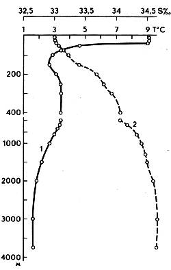
Vertical distribution of water temperature (1) and salinity (2) in the Bering Sea
IN warm years in the south, in the deep-water part of the sea, the cold intermediate layer may be absent in summer, then the temperature decreases relatively smoothly with depth with a general warming of the entire water column. The origin of the intermediate layer is associated with the influx of Pacific water, which is cooled from above as a result of winter convection. Convection reaches horizons of 150-250 m here, and under its lower boundary an increased temperature is observed - a warm intermediate layer. The maximum temperature varies from 3.4-3.5 to 3.7-3.9°. The depth of the core of the warm intermediate layer in the central regions of the sea is approximately 300 m, to the south it decreases to 200 m, and to the north and west it increases to 400 m or more. The lower boundary of the warm intermediate layer is blurred, approximately it is outlined in the layer of 650-900 m.
The deep water mass, which occupies most of the volume of the sea, does not differ significantly both in depth and in sea area. Over a distance of more than 3000 m, the temperature varies from approximately 2.7-3.0 to 1.5-1.8 ° at the bottom. Salinity is 34.3-34.8‰.
As we move south to the straits of the Aleutian ridge, the stratification of waters is gradually erased, the temperature of the core of the cold intermediate layer increases, approaching in value the temperature of the warm intermediate layer. The waters gradually acquire a qualitatively different structure than Pacific water.
In some areas, especially in shallow waters, the main water masses change, new masses appear that have local significance. For example, in the western part of the Gulf of Anadyr, a desalinated water mass is formed under the influence of continental runoff, and in the northern and eastern parts, a cold water mass of the Arctic type is formed. There is no warm intermediate layer here. In some shallow areas of the sea, cold waters are observed in the bottom layer in summer. Their formation is associated with the vortex water cycle. The temperature in these cold “spots” drops to –0.5-1°.
Due to autumn-winter cooling, summer heating and mixing in the Bering Sea, the surface water mass is most strongly transformed, as well as the cold intermediate layer. Intermediate Pacific water changes its characteristics very slightly throughout the year and only in a thin upper layer. Deep waters do not change noticeably throughout the year.
The water temperature on the sea surface generally decreases from south to north, with water in the western part of the sea being somewhat colder than in the eastern part. In winter, in the south, western part of the sea, the surface water temperature is usually 1-3°, and in the eastern part - 2-3°. In the north throughout the sea, water temperatures range from 0° to –1.5°. In spring, the water begins to warm up and the ice begins to melt, while the temperature rises slightly. In summer, the water temperature on the surface is 9-11° in the south of the western part and 8-10° in the south of the eastern part. In the northern regions of the sea it is 4° in the west and 4-6° in the east. In coastal shallow areas, surface water temperatures are slightly higher than in open areas of the Bering Sea.
The vertical distribution of water temperature in the open part of the sea is characterized by seasonal changes to horizons of 150-200 m, deeper than which they are practically absent.

Scheme of water exchange in the Okhotsk and Bering Seas
In winter, the surface temperature, equal to approximately 2°, extends to horizons of 140-150 m, below it rises to approximately 3.5° at horizons of 200-250 m, then its value almost does not change with depth.
In spring, the water temperature on the surface rises to approximately 3.8° and remains up to horizons of 40-50 m, then to horizons of 65-80 m it sharply, and then (up to 150 m) very smoothly decreases with depth and from a depth of 200 m it increases slightly to the bottom.
In summer, the water temperature on the surface reaches 7-8°, but drops very sharply (up to 2.5°) with a depth to the horizon of 50 m; below its vertical course is almost the same as in spring.
In general, water temperature in the open part of the Bering Sea is characterized by a relative homogeneity of spatial distribution in the surface and deep layers and relatively small seasonal fluctuations, which appear only to horizons of 200-300 m.
The salinity of the surface waters of the sea varies from 33-33.5‰ in the south to 31‰ in the east and northeast and up to 28.6‰ in the Bering Strait. Water is desalinated most significantly in spring and summer in the areas where the Anadyr, Yukon and Kuskokwim rivers confluence. However, the direction of the main currents along the coasts limits the influence of continental runoff on the deep sea areas.
The vertical distribution of salinity is almost the same in all seasons of the year. From the surface to the horizon of 100-125 m, it is approximately equal to 33.2-33.3‰. Salinity increases slightly from horizons of 125-150 to 200-250 m; deeper it remains almost unchanged to the bottom.
In accordance with small spatiotemporal changes in temperature and salinity, density also changes slightly. The distribution of oceanological characteristics by depth indicates a relatively weak vertical stratification of the waters of the Bering Sea. In combination with strong winds, this creates favorable conditions for the development of wind mixing. In the cold season, it covers the upper layers up to horizons of 100-125 m; in the warm season, when the waters are stratified more sharply and the winds are weaker than in autumn and winter, wind mixing penetrates to horizons of 75-100 m in the deep and up to 50-60 m in coastal areas.
Significant cooling of waters, and in the northern regions, intensive ice formation, contribute to the good development of autumn-winter convection in the sea. During October - November it captures the surface layer of 35-50 m and continues to penetrate deeper.
The penetration boundary of winter convection deepens as it approaches the coast due to enhanced cooling near the continental slope and shallows. In the southwestern part of the sea this decrease is especially large. This is associated with the observed lowering of cold waters along the coastal slope.
Due to the low air temperature due to the high latitude of the northwestern region, winter convection develops here very intensively and, probably, already in mid-January (due to the shallowness of the region) reaches the bottom.
Currents
As a result of the complex interaction of winds, the influx of water through the straits of the Aleutian ridge, tides and other factors, a field of constant currents in the sea is created.
The predominant mass of water from the ocean enters the Bering Sea through the eastern part of the Blizhny Strait, as well as through other significant straits of the Aleutian ridge.
Waters entering through the Blizhny Strait and spreading first into east direction, then turn north. At a latitude of about 55°, these waters merge with the waters coming from the Amchitka Strait, forming the main flow of the central part of the sea. This flow supports the existence of two stable gyres here - a large, cyclonic one, covering the central deep-water part of the sea, and a smaller, anticyclonic one. The waters of the main flow are directed to the northwest and reach almost the Asian shores. Here, most of the water turns along the coast to the southwest, giving rise to the cold Kamchatka Current, and enters the ocean through the Kamchatka Strait. Some of this water is discharged into the ocean through western part Blizhny Strait, and a very small part is included in the main circulation.
Waters entering through eastern straits The Aleutian ridge also crosses the central basin and moves to the north-northwest. At approximately latitude 60°, these waters divide into two branches: the northwestern one, moving towards the Gulf of Anadyr and then northeast into the Bering Strait, and the northeastern one, moving towards Norton Sound and then north into the Bering Strait. strait
The speeds of constant currents in the sea are low. The highest values (up to 25-50 cm/s) are observed in the areas of the straits, and in the open sea they are equal to 6 cm/s, and the speeds are especially low in the zone of the central cyclonic circulation.
Tides in the Bering Sea are mainly caused by the propagation of tidal waves from the Pacific Ocean.
In the Aleutian Straits, the tides have irregular diurnal and irregular semidiurnal patterns. Off the coast of Kamchatka, during intermediate phases of the Moon, the tide changes from semidiurnal to daily; at high declinations of the Moon it becomes almost purely diurnal, and at low declinations it becomes semidiurnal. On the Koryak coast, from Olyutorsky Bay to the mouth of the river. Anadyr, the tide is irregular semi-diurnal, but off the coast of Chukotka it is regular semi-diurnal. In the area of Provideniya Bay, the tide again becomes irregularly semidiurnal. In the eastern part of the sea, from Cape Prince of Wales to Cape Nome, the tides have both regular and irregular semidiurnal character.
South of the mouth of the Yukon, the tide becomes irregularly semidiurnal.
Tidal currents in the open sea are circular in nature, and their speed is 15-60 cm/s. Near the coast and in the straits, tidal currents are reversible, and their speed reaches 1-2 m/s.
Cyclonic activity developing over the Bering Sea causes the occurrence of very strong and sometimes prolonged storms. Particularly strong excitement develops from November to May. At this time of year, the northern part of the sea is covered with ice, and therefore the strongest waves are observed in the southern part. Here in May the frequency of waves of more than 5 points reaches 20-30%, and in the northern part of the sea it is absent due to ice. In August, waves and swells over 5 points reach their greatest development in the eastern part of the sea, where the frequency of such waves reaches 20%. In autumn, in the southeastern part of the sea, the frequency of strong waves is up to 40%.
With prolonged winds of average strength and significant acceleration of waves, their height reaches 6-8 m, with winds of 20-30 m/s or more - up to 10 m, and in some cases - up to 12 and even 14 m. Periods of storm waves reach up to 9-11 s, and with moderate waves - up to 5-7 s.

Kunashir Island
In addition to wind waves, a swell is observed in the Bering Sea, the greatest frequency of which (40%) occurs in autumn. In the coastal zone, the nature and parameters of waves are very different depending on the physical and geographical conditions of the area.
Ice cover
For most of the year, much of the Bering Sea is covered in ice. Ice in the sea is of local origin, i.e. are formed, destroyed and melted into the sea itself. Winds and currents bring a small amount of ice from the Arctic Basin into the northern part of the sea through the Bering Strait, which usually does not penetrate south of the island. St. Lawrence.
Ice conditions in the northern and southern parts of the sea differ. The approximate boundary between them is the extreme southern position of the ice during the year - in April. This month the edge runs from Bristol Bay through the Pribilof Islands and further west along the 57-58th parallel, and then drops south to the Commander Islands and runs along the coast to the southern tip of Kamchatka. The southern part of the sea does not freeze at all. Warm Pacific waters entering the Bering Sea through the Aleutian Straits push floating ice to the north, and the edge of the ice in the central part of the sea is always curved to the north.
The process of ice formation begins first in the northwestern part of the Bering Sea, where ice appears in October and gradually moves south. Ice appears in the Bering Strait in September. In winter, the strait is filled with solid broken ice, drifting north.
IN Gulf of Anadyr and Norton Sound, ice can be found as early as September. In early November, ice appears in the area of Cape Navarin, and in mid-November it spreads to Cape Olyutorsky. Off the coast of Kamchatka and the Commander Islands, floating ice usually appears in December and only as an exception in November. During winter, the entire northern part of the sea, up to approximately the 60° parallel, is filled with heavy, hummocky ice, the thickness of which reaches 6-10 m. To the south of the parallel, the Pribilof Islands are found broken ice and isolated ice fields.
However, even during the peak of ice formation, the open part of the Bering Sea is never covered with ice. In the open sea, under the influence of winds and currents, ice is in constant motion, and strong compression often occurs. This leads to the formation of hummocks, the maximum height of which can reach up to 20 m. Due to periodic compression and rarefaction of ice associated with tides, piles of ice, numerous polynyas and clearings are formed.
Fixed ice, which forms in closed bays and bays in winter, can be broken up and carried out to sea during stormy winds. The ice from the eastern part of the sea is carried north into the Chukchi Sea.
In April, the boundary of floating ice moves as far as possible to the south. From May, the ice begins to gradually collapse and retreat to the north. During July and August the sea is completely clear of ice, but even during these months ice can be found in the Bering Strait. Strong winds contribute to the destruction of the ice cover and the clearing of ice from the sea in summer.
In bays and bays, where the desalinating influence of river flow is felt, conditions for ice formation are more favorable than in the open sea. Winds have a great influence on the location of ice. Surge winds often clog individual bays, bays and straits with heavy ice brought from the open sea. On the contrary, rushing winds carry ice out to sea, sometimes clearing the entire coastal area.

Bird market
Economic importance
Fish of the Bering Sea are represented by more than 400 species, of which only no more than 35 are considered important commercial species. These are salmon, cod, and flounder. Perch, grenadier, capelin, sable fish, etc. are also caught in the sea.
Former inland sea Russian Empire is now the easternmost possessions of our state. The northeastern territories are still waiting for their conquerors. One of the storerooms natural resources this part of the planet is the Bering Sea, geographical position which not only plays a significant role in the development of local regions, but also opens up enormous prospects for Russia’s expanding economic activity in the Arctic latitudes.
Bering Sea. Description
The northern edge of the Pacific Basin is the most extensive of all the seas washing the shores of Russia. Its area is 2,315 thousand km 2. For comparison: the surface of the Black Sea is five and a half times smaller. The Bering Sea is the deepest among coastal seas and one of the deepest in the world. The lowest elevation is at a depth of 4,151 m, and the average depth is 1,640 m. Deep-water areas are located on the southern side of the water area and are called the Aleutian and Commander basins. It is surprising that with such indicators, about half of the seabed is only half a kilometer away from the sea surface. The relative shallowness of the sea allows us to classify the sea as a continental-oceanic type. The northern Far Eastern reservoir holds 3.8 million km 3 of water. Most scientists explain the origin of the Bering Sea by being cut off from the rest of the ocean by the Commander-Aleutian ridge, which arose as a result of global tectonic processes in the distant past.
History of discovery and development
The modern hydronym comes from the name of the first European explorer Vitus Bering. The Dane, in Russian service, organized two expeditions in 1723-1943. The purpose of his travels was to search for the border between Eurasia and America. Although the strait between the continents was discovered by topographers Fedorov, Gvozdev and Mashkov, it was later named after the hired navigator. During Bering's second expedition, the territories of the North Pacific Ocean were explored and Alaska was discovered. On old Russian maps, the northern body of water is called the Bobrov Sea, or the Kamchatka Sea. The coast has been explored by Russian explorers since the beginning of the 18th century. Thus, Timofey Perevalov in the 30s compiled a map of some territories of Kamchatka and Chukotka. Thirty years later, D. Cook visited these places. The tsarist government sent expeditions here under the leadership of Sarychev, Bellinghausen and Kotzebue. Modern name was proposed by the Frenchman Fliorier. This term came into wide use thanks to the Russian navigator Admiral Golovnin.
Description of the geographical location of the Bering Sea
Geomorphological characteristics are determined by natural boundaries coastline in the east and west, a group of islands in the south and a speculative boundary in the north. The northern border adjoins the waters of the strait of the same name, connecting with the Chukchi Sea. The demarcation runs from Cape Novosilsky on Chukotka to Cape York on the Seward Peninsula. From east to west the sea stretches for 2,400 km, and from north to south - 1,600 km. The southern border is marked by the archipelagos of the Commander and Aleutian Islands. Pieces of land in the ocean outline a kind of giant arc. Beyond Pacific Ocean. The northernmost edge of the largest body of water on the planet is the Bering Sea. The geometric pattern of the water area is characterized by a narrowing of the water space towards the Arctic Circle. The Bering Strait separates two continents: Eurasia and North America- and two oceans: the Pacific and the Arctic. The northwestern waters of the sea wash the shores of Chukotka and the Koryak Upland, the northeastern waters wash the west of Alaska. The flow of continental waters is negligible. From the side of Eurasia, Anadyr flows into the sea, and on the shores of Alaska the legendary Yukon has its mouth. The Kuskokuim River flows into the sea in the bay of the same name.

Coast and islands
Numerous bays, bays and peninsulas form the rugged coastal pattern that characterizes the Bering Sea. The Olyutorsky, Karaginsky and Anadyrsky bays are the largest on the Siberian shores. The vast bays of Bristol, Norton and Kuskokwim are located on the shores of Alaska. The few islands are different in origin: continental islands are small areas of land within the boundaries of the continental plateaus, islands of volcanic origin make up the inner, and folded ones make up the outer belt of the Commander-Aleutian arc. The ridge itself stretches 2,260 km from Kamchatka to Alaska. The total area of the islands is 37,840 km2. The Commander Islands belong to Russia, all the rest are USA: Pribylova, St. Larentia, St. Matvey, Karaginsky, Nunivak and, of course, the Aleuts.
Climate
Significant fluctuations in average daily temperatures, more typical of continental landmasses, characterize the Bering Sea. Geographical location is a determining factor in the formation of the region's climate. Most of the sea's territory is in the subarctic zone. The northern side belongs to the Arctic zone, and the southern side to temperate latitudes. The western side is cooling more strongly. And due to the fact that the Siberian territories adjacent to the sea warm up less, this part of the water area is much colder than the eastern one. Above central part In the warm season, the sea air warms up to +10 °C. In winter, despite the penetration of Arctic air masses, it does not fall below - 23 °C.

Hydrosphere
In the upper horizons, the water temperature decreases towards northern latitudes. The waters washing the Eurasian coast are colder than the North American zone. In the coldest time of the year off the coast of Kamchatka, the sea surface temperature is +1…+3 °C. Off the coast of Alaska it is one or two degrees higher. In summer, the upper layers warm up to +9 °C. The significant depth of the straits of the Aleutian ridge (up to 4,500 m) promotes active water exchange with the Pacific Ocean at all levels. The influence of the waters of the Chukchi Sea is minimal due to the shallow depth of the Bering Strait (42 m).
In terms of the degree of wave formation, the Bering Sea also occupies first place among the seas of Russia. Which ocean is the higher water area is reflected in the characteristics of the degree of storminess of the periphery. Significant depths and storm activity are the result of strong waves. For most of the year, waves with a height of water crests of up to 2 m are observed. In winter, there are a number of storms with wave heights of up to 8 m. Over the last hundred years of observations, cases of waves with a height of up to 21 m have been recorded in ship log books.
Ice conditions
The ice cover is local in origin: the massif forms and melts in the water area itself. The Bering Sea in the northern part becomes covered with ice at the end of September. First of all, the ice shell binds closed bays, bays and the coastal zone, and the range reaches its greatest distribution in April. Melting ends only in mid-summer. Thus, the surface in the high latitude zone is covered with ice for more than nine months a year. In the Gulf of St. Lawrence, off the coast of Chukotka, in some seasons the ice does not melt at all. The southern side, on the contrary, does not freeze throughout the year. Warm masses from the ocean enter through the Aleutian straits, which push the edge of the ice closer to the north. The sea strait between the continents is clogged with pack ice most of the year. Some ice fields reach a thickness of six meters. Off the coast of Kamchatka, drifting massifs are found even in August. Wiring sea vessels traveling along the Northern Sea Route requires the participation of icebreakers.

Animal and plant life
Gulls, guillemots, puffins and other feathered inhabitants of the polar latitudes establish their colonies on the coastal rocks. Along the gently sloping shores you can find rookeries of walruses and sea lions. These real monsters of the Bering Sea reach a length of more than three meters. IN large quantities there are sea otters. Marine flora is represented by five dozen coastal plants. In the south the vegetation is more diverse. Phytoalgae promote the development of zooplankton, which in turn attracts many marine mammals. Humpback whales, representatives of the gray and toothed species of cetaceans - killer whales and sperm whales - come here to feed. The Bering Sea is exceptionally rich in fish: the underwater fauna is represented by almost three hundred species. Sharks also live in northern waters. The polar fish lives at great depths, and the dangerous predator - the salmon - does not show aggression towards people. Without a doubt, the depths of the sea have not yet revealed all their secrets.

Between Asia and America
Small groups of fur traders began to develop the northeastern waters in the 40s of the 18th century. The islands of the Aleutian archipelago, like a huge natural bridge, allowed traders to reach the shores of Alaska. The position of the Bering Sea, namely its ice-free part, contributed to the establishment of busy shipping between Petropavlovsk on Kamchatka and the newly built strongholds on the American mainland. True, Russian expansion in America did not last long, only about eighty years.
Territorial disputes
During the reign of M. S. Gorbachev, an agreement was concluded on concessions in favor of the United States of a significant part of the sea and continental shelf with total area almost 78 thousand km 2. In June 1990, USSR Foreign Minister E. Shevardnadze and Secretary of State D. Baker signed a corresponding agreement. The domestic trawl fleet has lost the opportunity to catch fish in the middle part of the sea. In addition, Russia has lost a significant segment of the promising oil-bearing province on the shelf. The bill was approved by the US Congress that same year. In Russia, the agreement is constantly criticized and has not yet been ratified by parliament. The dividing line was named Shevardnadze - Baker.

Economic activity
The region's economy consists of two components: the fishing industry and maritime transport. Inexhaustible fish resources contribute to the active activities of Russian fishing companies. Many processing plants have been built on the coast of Kamchatka. Herring, salmon, cod and flounder species are fished on an industrial scale. On a small scale, mainly in the interests of the indigenous population, hunting of marine animals and cetaceans is allowed. In recent years, scientific interest in this Far Eastern region has increased. This is mainly caused by the search for hydrocarbon deposits on the shelf. Three small oil basins have been discovered off the coast of Chukotka.
Klondike at the bottom of the ocean
On sea depths Comprehensive studies have not yet been carried out, the purpose of which would be to search for minerals or collect geological data for further promising prospects. Within the boundaries of the water area, mineral deposits are unknown. And in coastal areas, deposits of tin and semi-precious stones have been discovered. Hydrocarbon deposits have been discovered in the Anadyr Basin. But on the opposite coast, they have been plowing up the bottom in search of yellow metal for several years. A hundred years ago, the impetus for the development of the region was gold found on the shores of the Yukon and the subsequent gold rush. The Bering Sea at the beginning of the 21st century gives new hope. The thirst for profit gives rise to ingenious technical devices. An ordinary excavator, a screen for sifting inert materials and an improvised room resembling a construction trailer in which an electric generator is placed are installed on an old barge. Such technical “monsters” of the Bering Sea are becoming increasingly widespread.

Discovery Channel Original Project
For the fifth season in a row, the American popular science television channel Discovery has been monitoring the fate of those seeking easy money. As soon as the water area is freed from ice, prospectors from all over the world gather on the coast of Alaska, and the gold rush resumes in the northern latitudes. The Bering Sea off the coast has shallow depth. This will allow you to use available tools. An improvised fleet defies the elements. The treacherous sea tests everyone's strength and courage, and the seabed is reluctant to share its treasures. Only a few lucky people were enriched by the gold rush. The ice of the Bering Sea allows some enthusiasts to continue work in winter. Over the course of several episodes of the documentary, you can watch three teams of gold miners risking their lives for the treasured handful of yellow metal.
It occupies the northernmost position among all the Far Eastern seas. This sea is located between two large continents, Asia and America. The Bering Sea is delimited from the waters of the Pacific Ocean by the Commander-Aleutian arc. Most of this sea is made up of natural boundaries; in some areas, the boundaries are conventional lines. The Bering Sea is a marginal sea of mixed continental-oceanic type.
In terms of its size and depth, this sea ranks first among all Russian seas. The area of the Bering Sea is 2315 thousand km2, the volume of its waters is 3796 thousand km3. The average depth of the sea is 1640 m, the greatest depth is 4151 m. A fairly small number of islands are located in the waters of the Bering Sea.
The coastline is heavily indented. There are a large number of bays, bays, capes and straits. Many straits connect the sea with the Pacific Ocean. The depth of some straits exceeds 1000–2000 m (for example, the depth of the Kamchatka Strait is 4000–4500 m). Thanks to the large number of straits, there is good water exchange with the Pacific Ocean. The shores washed by the sea are mostly high and have steep slopes. Only the middle part of the western and eastern shores is a low-lying zone.
The continental slope extends from northwest to southeast. The depth of the sea here varies from 22 to 3000 m. The seabed has many underwater valleys. Some of them are submarine canyons and have steep, sharp slopes. In the southwestern and central parts of the Bering Sea there is a deep-water zone. It occupies a significant part of the total water space (about 40% of the total area). The bottom here is almost monotonous. and ridges located in the deep-sea zone are insignificant. The most deep places seas are located near the Aleutian Islands.
The Bering Sea lies in three. Its main part is characterized by a subarctic climate. The extreme northern zone of the sea has, and the southern one belongs to the zone. The northern part of the sea is characterized by some continental features. In sea areas far from the coast, this continentality is weakly expressed. In the southern parts of the sea it is sea, therefore quite soft. Here minor changes are observed both during the day and throughout the year. In this zone, a large number predominates and is observed. The western part of the sea is practically not affected, but here the influence of the mainland is felt. The Asian mainland adjacent to the Bering Sea is much colder than the American mainland, so the western Bering Sea area is more different low temperatures compared to the east.
In cold seasons, the features are determined by the Aleutian minimum, Polar maximum and Siberian. At this time, all directions are observed here. But the most frequent are northern, northeastern and northwestern winds. Only in the southeast of the sea do southern and southwestern winds occur. In areas of the sea located close to the coast, the average wind speed is about 6 – 8 m/s. In areas of the open sea, their speed increases to 6 – 12 m/s.
Northern winds blow from and bring with them sea air. From the Asian mainland, westerly winds carry cold, dry continental winds. Continental Arctic winds blow from the east from the American continent. Continental Arctic and marine polar air masses interact over the sea. Upon their contact, it is formed. Over the Bering Sea, winds constantly appear, which increase the strength of northern winds in the western part and reduce them in the eastern part.
Powerful storm winds are observed in the western zone of the sea. During a storm, the wind speed increases to 30 - 40 m/s. As a rule, such weather lasts for a day. In some cases, the wind weakens a little, but continues to blow for 7 to 9 days. During the cold period, there can be 5–10 stormy days per month, sometimes up to 15–20 days.
In winter, the temperature drops from south to north. In the coldest time, the average temperature is +1 – 4°C in the southern parts of the sea. In the north and northeast, temperatures on average drop to – 15 – 20°C. In the open sea the air is warmer than in coastal areas. Off the coast of Alaska, temperatures can drop to -48°C. In the open sea, the minimum temperature is never lower than – 24°C.

By spring, the effects of the Aleutian Low, Polar High and Siberian Anticyclone decrease or completely disappear. As a result of these changes, winds from the southwest, west and west dominate in the spring. southeast directions. Their speed is 4 – 5 m/s in the western part of the sea, and 4 – 7 m/s in the east. Near the coast, the wind speed becomes lower. The number of storms in summer is much less than in winter. The southern part of the sea is sometimes hit by a cyclone (), which contributes to the emergence of powerful storms and. The typhoon rages for several days. Most often they occur from June to October.
In summer, the average temperature of the warmest months ranges from + 4 to + 13°C. The air near the coast warms up more than on the open sea. Winter in the southern parts of the sea is mostly mild, in the north it is cold. In summer, cool, cloudy weather prevails everywhere.
The mainland in the Bering Sea is small and amounts to about 400 km 3 in one year. The most that carry their waters to the sea are the Yukon (provides 173 km 3 of fresh water), Kuskokwim (50 km 3 per year) and Anadyr (41 km 3 per year). Largest part river water enters the sea during the summer. During this period, the influence of river waters in the coastal zone is felt.
The Bering Sea is an important route. In this sea the Northern Sea Route and the Far Eastern Sea Route connect. Various goods are transported through the waters of the Bering Sea for the eastern part of the continent. This sea has a well-developed marine environment. In the sea waters they catch salmon, cod, pollock, herring, and flounder. They hunt whales and sea animals (though extremely rarely).
The former inland sea of the Russian Empire is now the easternmost possessions of our state. The northeastern territories are still waiting for their conquerors. One of the storehouses of natural resources of this part of the planet is the Bering Sea, the geographical location of which not only plays a significant role in the development of local regions, but also opens up enormous prospects for Russia’s expanding economic activity in the Arctic latitudes.
Bering Sea. Description
The northern edge of the Pacific Basin is the most extensive of all the seas washing the shores of Russia. Its area is 2,315 thousand km 2. For comparison: the surface of the Black Sea is five and a half times smaller. The Bering Sea is the deepest of the coastal seas and one of the deepest in the world. The lowest elevation is at a depth of 4,151 m, and the average depth is 1,640 m. Deep-water areas are located on the southern side of the water area and are called the Aleutian and Commander basins. It is surprising that with such indicators, about half of the seabed is only half a kilometer away from the sea surface. The relative shallowness of the sea allows us to classify the sea as a continental-oceanic type. The northern Far Eastern reservoir holds 3.8 million km 3 of water. Most scientists explain the origin of the Bering Sea by being cut off from the rest of the ocean by the Commander-Aleutian ridge, which arose as a result of global tectonic processes in the distant past.
History of discovery and development
The modern hydronym comes from the name of the first European explorer Vitus Bering. The Dane, in Russian service, organized two expeditions in 1723-1943. The purpose of his travels was to search for the border between Eurasia and America. Although the strait between the continents was discovered by topographers Fedorov, Gvozdev and Mashkov, it was later named after the hired navigator. During Bering's second expedition, the territories of the North Pacific Ocean were explored and Alaska was discovered. On old Russian maps, the northern body of water is called the Bobrov Sea, or the Kamchatka Sea. The coast has been explored by Russian explorers since the beginning of the 18th century. Thus, Timofey Perevalov in the 30s compiled a map of some territories of Kamchatka and Chukotka. Thirty years later, D. Cook visited these places. The tsarist government sent expeditions here under the leadership of Sarychev, Bellinghausen and Kotzebue. The modern name was proposed by the Frenchman Fliorier. This term came into wide use thanks to the Russian navigator Admiral Golovnin.
Description of the geographical location of the Bering Sea
Geomorphological characteristics are determined by the natural boundaries of the coastline in the east and west, a group of islands in the south and a speculative boundary in the north. The northern border adjoins the waters of the strait of the same name, connecting with the Chukchi Sea. The demarcation runs from Cape Novosilsky on Chukotka to Cape York on the Seward Peninsula. From east to west the sea stretches for 2,400 km, and from north to south - 1,600 km. The southern border is marked by the archipelagos of the Commander and Aleutian Islands. Pieces of land in the ocean outline a kind of giant arc. Beyond it is the Pacific Ocean. The northernmost edge of the largest body of water on the planet is the Bering Sea. The geometric pattern of the water area is characterized by a narrowing of the water space towards the Arctic Circle. The Bering Strait separates two continents: Eurasia and North America - and two oceans: the Pacific and the Arctic. The northwestern waters of the sea wash the shores of Chukotka and the Koryak Upland, the northeastern waters wash the west of Alaska. The flow of continental waters is negligible. From the side of Eurasia, Anadyr flows into the sea, and on the shores of Alaska the legendary Yukon has its mouth. The Kuskokuim River flows into the sea in the bay of the same name.
Coast and islands
Numerous bays, bays and peninsulas form the rugged coastal pattern that characterizes the Bering Sea. The Olyutorsky, Karaginsky and Anadyrsky bays are the largest on the Siberian shores. The vast bays of Bristol, Norton and Kuskokwim are located on the shores of Alaska. The few islands are different in origin: continental islands are small areas of land within the boundaries of the continental plateaus, islands of volcanic origin make up the inner, and folded ones make up the outer belt of the Commander-Aleutian arc. The ridge itself stretches 2,260 km from Kamchatka to Alaska. The total area of the islands is 37,840 km2. The Commander Islands belong to Russia, all the rest are USA: Pribylova, St. Larentia, St. Matvey, Karaginsky, Nunivak and, of course, the Aleuts.
Climate
Significant fluctuations in average daily temperatures, more typical of continental landmasses, characterize the Bering Sea. Geographical location is a determining factor in the formation of the region's climate. Most of the sea's territory is in the subarctic zone. The northern side belongs to the Arctic zone, and the southern side to temperate latitudes. The western side is cooling more strongly. And due to the fact that the Siberian territories adjacent to the sea warm up less, this part of the water area is much colder than the eastern one. Over the central part of the sea in the warm season, the air warms up to +10 °C. In winter, despite the penetration of Arctic air masses, it does not fall below - 23 °C.
Hydrosphere
In the upper horizons, the water temperature decreases towards northern latitudes. The waters washing the Eurasian coast are colder than the North American zone. In the coldest time of the year off the coast of Kamchatka, the sea surface temperature is +1…+3 °C. Off the coast of Alaska it is one or two degrees higher. In summer, the upper layers warm up to +9 °C. The significant depth of the straits of the Aleutian ridge (up to 4,500 m) promotes active water exchange with the Pacific Ocean at all levels. The influence of the waters of the Chukchi Sea is minimal due to the shallow depth of the Bering Strait (42 m).
In terms of the degree of wave formation, the Bering Sea also occupies first place among the seas of Russia. Which ocean is the higher water area is reflected in the characteristics of the degree of storminess of the periphery. Significant depths and storm activity are the result of strong waves. For most of the year, waves with a height of water crests of up to 2 m are observed. In winter, there are a number of storms with wave heights of up to 8 m. Over the last hundred years of observations, cases of waves with a height of up to 21 m have been recorded in ship log books.
Ice conditions
The ice cover is local in origin: the massif forms and melts in the water area itself. The Bering Sea in the northern part becomes covered with ice at the end of September. First of all, the ice shell binds closed bays, bays and the coastal zone, and the range reaches its greatest distribution in April. Melting ends only in mid-summer. Thus, the surface in the high latitude zone is covered with ice for more than nine months a year. In the Gulf of St. Lawrence, off the coast of Chukotka, in some seasons the ice does not melt at all. The southern side, on the contrary, does not freeze throughout the year. Warm masses from the ocean enter through the Aleutian straits, which push the edge of the ice closer to the north. The sea strait between the continents is clogged with pack ice most of the year. Some ice fields reach a thickness of six meters. Off the coast of Kamchatka, drifting massifs are found even in August. Piloting ships traveling along the Northern Sea Route requires the participation of icebreakers.
Animal and plant life
Gulls, guillemots, puffins and other feathered inhabitants of the polar latitudes establish their colonies on the coastal rocks. Along the gently sloping shores you can find rookeries of walruses and sea lions. These real monsters of the Bering Sea reach a length of more than three meters. Sea otters are found in large numbers. Marine flora is represented by five dozen coastal plants. In the south the vegetation is more diverse. Phytoalgae promote the development of zooplankton, which in turn attracts many marine mammals. Humpback whales, representatives of the gray and toothed species of cetaceans - killer whales and sperm whales - come here to feed. The Bering Sea is exceptionally rich in fish: the underwater fauna is represented by almost three hundred species. Sharks also live in northern waters. The polar fish lives at great depths, and the dangerous predator - the salmon - does not show aggression towards people. Without a doubt, the depths of the sea have not yet revealed all their secrets.
Between Asia and America
Small groups of fur traders began to develop the northeastern waters in the 40s of the 18th century. The islands of the Aleutian archipelago, like a huge natural bridge, allowed traders to reach the shores of Alaska. The position of the Bering Sea, namely its ice-free part, contributed to the establishment of busy shipping between Petropavlovsk on Kamchatka and the newly built strongholds on the American mainland. True, Russian expansion in America did not last long, only about eighty years.
Territorial disputes
During the reign of M.S. Gorbachev, an agreement was concluded on concessions in favor of the United States of a significant part of the sea and continental shelf with a total area of almost 78 thousand km 2. In June 1990, USSR Foreign Minister E. Shevardnadze and Secretary of State D. Baker signed a corresponding agreement. The domestic trawl fleet has lost the opportunity to catch fish in the middle part of the sea. In addition, Russia has lost a significant segment of the promising oil-bearing province on the shelf. The bill was approved by the US Congress that same year. In Russia, the agreement is constantly criticized and has not yet been ratified by parliament. The dividing line was named Shevardnadze - Baker.
Economic activity
The region's economy consists of two components: fishing and maritime transport. Inexhaustible fish resources contribute to the active activities of Russian fishing companies. Many processing plants have been built on the coast of Kamchatka. Herring, salmon, cod and flounder species are fished on an industrial scale. On a small scale, mainly in the interests of the indigenous population, hunting of marine animals and cetaceans is allowed. In recent years, scientific interest in this Far Eastern region has increased. This is mainly caused by the search for hydrocarbon deposits on the shelf. Three small oil basins have been discovered off the coast of Chukotka.
Klondike at the bottom of the ocean
Comprehensive research has not yet been carried out at the sea depths, the purpose of which would be to search for minerals or collect geological data for further promising searches. Within the boundaries of the water area, mineral deposits are unknown. And in coastal areas, deposits of tin and semi-precious stones have been discovered. Hydrocarbon deposits have been discovered in the Anadyr Basin. But on the opposite coast, they have been plowing up the bottom in search of yellow metal for several years. A hundred years ago, the impetus for the development of the region was gold found on the shores of the Yukon and the subsequent gold rush. The Bering Sea at the beginning of the 21st century gives new hope. The thirst for profit gives rise to ingenious technical devices. An ordinary excavator, a screen for sifting inert materials and an improvised room resembling a construction trailer in which an electric generator is placed are installed on an old barge. Such technical “monsters” of the Bering Sea are becoming increasingly widespread.
Discovery Channel Original Project
For the fifth season in a row, the American popular science television channel Discovery has been monitoring the fate of those seeking easy money. As soon as the water area is freed from ice, prospectors from all over the world gather on the coast of Alaska, and the gold rush resumes in the northern latitudes. The Bering Sea off the coast has shallow depth. This will allow you to use available tools. An improvised fleet defies the elements. The treacherous sea tests everyone's strength and courage, and the seabed is reluctant to share its treasures. Only a few lucky people were enriched by the gold rush. The ice of the Bering Sea allows some enthusiasts to continue work in winter. Over the course of several episodes of the documentary, you can watch three teams of gold miners risking their lives for the treasured handful of yellow metal.
The Bering Strait connects with the Chukchi Sea of the Arctic Ocean. Area 2304 thousand km², average depth 1598 m (maximum 4191 m), average volume of water 3683 thousand km³, length from north to south 1632 km, from west to east 2408 km.
The shores are predominantly high rocky, heavily indented, forming numerous bays and bays. Most large bays: Anadyrsky and Olyutorsky on the shore, Bristol and Norton in the east. A large number of rivers flow into the Bering Sea, the largest of which are the Anadyr, Apuka in the west, and the Yukon and Kuskokwim in the east. The islands of the Bering Sea are of continental origin. The largest of them are Karaginsky, St. Lawrence, Nunivak, Pribilof, St. Matthew.
The Bering Sea is the largest of the geosynclinal seas Far East. The bottom topography includes a continental shelf (45% of the area), a continental slope, underwater ridges and a deep-sea basin (36.5% of the area). The shelf occupies the northern and northeastern parts of the sea, characterized by flat terrain, complicated by numerous shoals, basins, flooded valleys and the upper reaches of underwater canyons. Sediments on the shelf are predominantly terrigenous (sands, sandy silts, and coarse clastic near the coast).
The continental slope for the most part has a significant steepness (8-15°), is dissected by underwater canyons, and is often complicated by steps; south of the Pribilof Islands it is flatter and wider. The continental slope of Bristol Bay is complexly dissected by ledges, hills, and depressions, which is associated with intense tectonic fragmentation. The sediments of the continental slope are predominantly terrigenous (sandy silts), with numerous outcrops of bedrock Paleogene and Neogene-Quaternary rocks; in the Bristol Bay area there is a large admixture of volcanic material.
The Shirshov and Bowers submarine ridges are arched rises with volcanic forms. On the Bowers Ridge, diorite outcrops were discovered, which, along with the arc-shaped outlines, brings it closer to the Aleutian island arc. The Shirshov Ridge has a similar structure to the Olyutorsky Ridge, composed of volcanogenic and flysch rocks of the Cretaceous period.
The Shirshov and Bowers submarine ridges separate the deep-sea trench of the Bering Sea. In the west of the basin: Aleutian, or Central (maximum depth 3782 m), Bowers (4097 m) and Komandorskaya (3597 m). The bottom of the basins is a flat abyssal plain, composed of diatomaceous silts on the surface, with a noticeable admixture of volcanogenic material near the Aleutian arc. According to geophysical data, the thickness of the sedimentary layer in deep-sea basins reaches 2.5 km; beneath it lies a basalt layer about 6 km thick. The deep-water part of the Bering Sea is characterized by a suboceanic type of the earth's crust.
The climate is formed under the influence of the adjacent land, the proximity of the polar basin in the north and the open Pacific Ocean in the south and, accordingly, the centers of atmospheric action developing above them. The climate of the northern part of the sea is arctic and subarctic, with pronounced continental features; southern part - temperate, marine. In winter, under the influence of the Aleutian minimum air pressure (998 mbar), a cyclonic circulation develops over the Bering Sea, due to which East End The sea, where air is brought from the Pacific Ocean, turns out to be somewhat warmer than the western part, which is under the influence of cold Arctic air (which comes with the winter monsoon). Storms are frequent during this season, the frequency of which in some places reaches 47% per month. average temperature air in February varies from -23°C in the north to O. -4°C in the south. In summer, the Aleutian minimum disappears and southerly winds dominate over the Bering Sea, which in the western part of the sea is the summer monsoon. Storms are rare in summer. The average air temperature in August varies from 5°C in the north to 10°C in the south. The average annual cloudiness is 5-7 points in the north, 7-8 points per year in the south. Precipitation varies from 200-400 mm per year in the north to 1500 mm per year in the south.
The hydrological regime is determined climatic conditions, water exchange with the Chukchi Sea and the Pacific Ocean, continental runoff and desalination of surface sea waters during ice melting. Surface currents form a counterclockwise gyre, along the eastern periphery of which they flow north warm waters from the Pacific Ocean - the Bering Sea branch of the Kuroshio warm current system. Part of this water flows through the Bering Strait into the Chukchi Sea, the other part deviates to the west and then follows south along the Asian coast, receiving the cold waters of the Chukchi Sea. The South Stream forms the Kamchatka Current, which carries the waters of the Bering Sea into the Pacific Ocean. This current pattern is subject to noticeable changes depending on the prevailing winds. Bering Sea tides are mainly caused by the propagation of tidal waves from the Pacific Ocean. In the western part of the sea (up to 62° north latitude) the highest tide height is 2.4 m, in Cross Bay 3 m, in the eastern part 6.4 m (Bristol Bay). The surface water temperature in February reaches 2°C only in the south and southwest; in the rest of the sea it is below -1°C. In August, temperatures rise to 5°-6°C in the north and 9°-10°C in the south. Salinity under the influence of river waters and melting ice is significantly lower than in the ocean and is equal to 32.0-32.5‰, and in the south it reaches 33‰. In coastal areas it decreases to 28-30‰. In the subsurface layer in the northern part of the Bering Sea, the temperature is -1.7 ° C, salinity is up to 33‰. In the southern part of the sea, at a depth of 150 m, the temperature is 1.7°C, salinity is 33.3‰ and more, and in the layer from 400 to 800 m, respectively, more than 3.4°C and more than 34.2‰. At the bottom the temperature is 1.6°C, salinity 34.6‰.
For most of the year the Bering Sea is covered floating ice, which in the north begin to form in September - October. In February - March, almost the entire surface is covered with ice, which is carried out into the Pacific Ocean along the Kamchatka Peninsula. The Bering Sea is characterized by the phenomenon of "sea glow".
In accordance with the difference in hydrological conditions of the northern and southern parts The northern Bering Sea is characterized by representatives of arctic forms of flora and fauna, while the southern one is characterized by boreal ones. The south is home to 240 species of fish, of which there are especially many flounders (flounder, halibut) and salmon (pink salmon, chum salmon, chinook salmon). There are numerous mussels, balanuses, polychaete worms, bryozoans, octopuses, crabs, shrimps, etc. The north is home to 60 species of fish, mainly cod. Among the mammals that characterize the Bering Sea, the fur seal, sea otter, seals, bearded seal, spotted seal, sea lion, gray whale, humpback whale, sperm whale, etc. are typical. The fauna of birds (guillemots, guillemots, puffins, kittiwake gulls, etc.) is abundant. bazaars." In the Bering Sea, intensive whaling is carried out, mainly for sperm whales, as well as fishing and sea animal hunting (fur seal, sea otter, seal, etc.). The Bering Sea is of great transport importance for Russia as a link in the Northern Sea Route. Main ports: Provideniya (Russia), Nome (USA).


